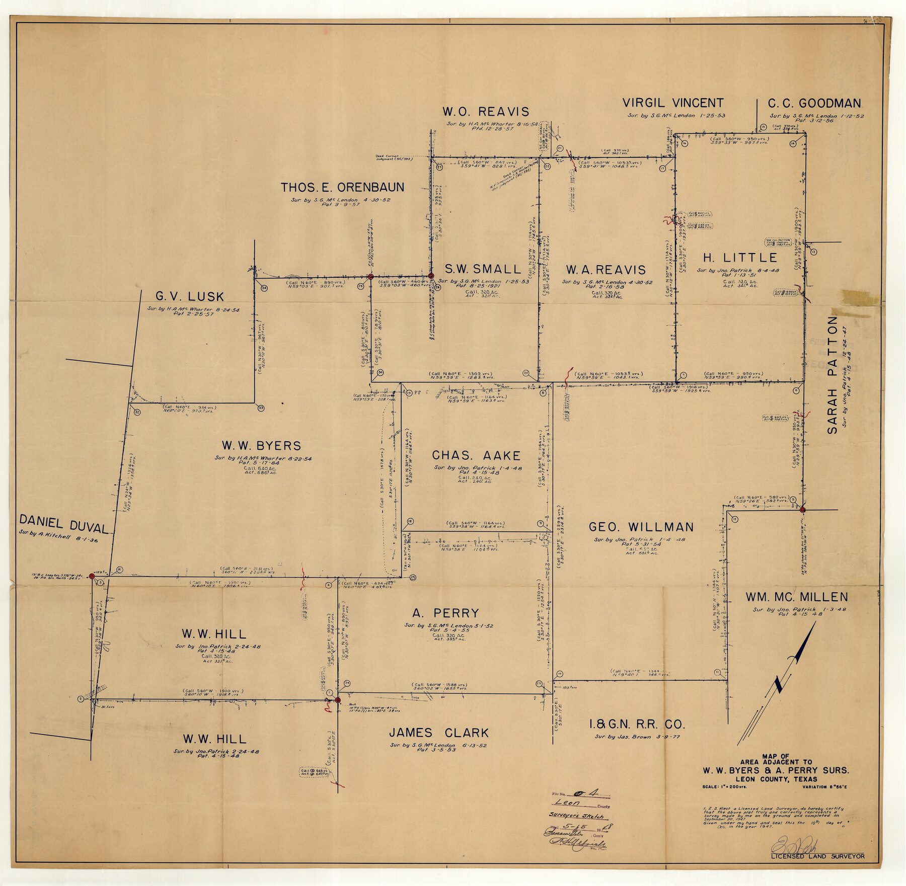
Leon County Rolled Sketch 4
Map of area adjacent to W.W. Byers & A. Perry surs., Leon County, Texas
-
Map/Doc
9426
-
Collection
General Map Collection
-
Object Dates
1947/9/20 (Survey Date)
1948/5/15 (File Date)
1947/12/10 (Creation Date)
-
People and Organizations
E.S. Rest (Surveyor/Engineer)
-
Counties
Leon
-
Subjects
Surveying Rolled Sketch
-
Height x Width
34.6 x 35.4 inches
87.9 x 89.9 cm
-
Medium
van dyke/brownline/sepia
-
Scale
1" = 200 varas
Part of: General Map Collection
Right of Way and Track Map, Galveston, Harrisburg & San Antonio Ry. operated by the T. & N. O. R.R. Co., Victoria Division, Rosenberg to Beeville

Print $40.00
- Digital $50.00
Right of Way and Track Map, Galveston, Harrisburg & San Antonio Ry. operated by the T. & N. O. R.R. Co., Victoria Division, Rosenberg to Beeville
Size 24.3 x 55.8 inches
Map/Doc 76162
Kinney County Working Sketch 51

Print $20.00
- Digital $50.00
Kinney County Working Sketch 51
1980
Size 34.6 x 47.2 inches
Map/Doc 70233
Flight Mission No. DQN-5K, Frame 38, Calhoun County

Print $20.00
- Digital $50.00
Flight Mission No. DQN-5K, Frame 38, Calhoun County
1953
Size 19.1 x 22.7 inches
Map/Doc 84386
Reeves County Sketch File 2

Print $26.00
- Digital $50.00
Reeves County Sketch File 2
Size 31.2 x 19.6 inches
Map/Doc 12239
Bexar County Sketch File 37

Print $5.00
- Digital $50.00
Bexar County Sketch File 37
1861
Size 16.2 x 8.2 inches
Map/Doc 14512
Shelby County Rolled Sketch 8

Print $20.00
- Digital $50.00
Shelby County Rolled Sketch 8
Size 40.4 x 45.5 inches
Map/Doc 9923
Flight Mission No. DQN-3K, Frame 7, Calhoun County

Print $20.00
- Digital $50.00
Flight Mission No. DQN-3K, Frame 7, Calhoun County
1953
Size 18.6 x 22.2 inches
Map/Doc 84339
Jefferson County Rolled Sketch 30

Print $20.00
- Digital $50.00
Jefferson County Rolled Sketch 30
1954
Size 34.1 x 39.9 inches
Map/Doc 6392
Harris County Working Sketch 84

Print $20.00
- Digital $50.00
Harris County Working Sketch 84
1970
Size 36.2 x 33.7 inches
Map/Doc 65976
Harris County Working Sketch 60

Print $20.00
- Digital $50.00
Harris County Working Sketch 60
1953
Size 31.8 x 35.2 inches
Map/Doc 65952
Glasscock County Sketch File 3

Print $3.00
- Digital $50.00
Glasscock County Sketch File 3
1931
Size 11.1 x 14.8 inches
Map/Doc 11560
Lipscomb County Boundary File 1

Print $16.00
- Digital $50.00
Lipscomb County Boundary File 1
Size 9.0 x 8.0 inches
Map/Doc 56307
You may also like
Flight Mission No. DCL-6C, Frame 5, Kenedy County

Print $20.00
- Digital $50.00
Flight Mission No. DCL-6C, Frame 5, Kenedy County
1943
Size 18.4 x 22.4 inches
Map/Doc 85865
Val Verde County Working Sketch 87

Print $20.00
- Digital $50.00
Val Verde County Working Sketch 87
1973
Size 37.1 x 33.8 inches
Map/Doc 72222
Starr County Rolled Sketch 28

Print $20.00
- Digital $50.00
Starr County Rolled Sketch 28
1941
Size 29.0 x 20.6 inches
Map/Doc 7811
Crosby County Working Sketch 6

Print $20.00
- Digital $50.00
Crosby County Working Sketch 6
1912
Size 19.4 x 18.0 inches
Map/Doc 68440
General Highway Map, Goliad County, Texas

Print $20.00
General Highway Map, Goliad County, Texas
1961
Size 18.2 x 24.7 inches
Map/Doc 79481
McMullen County Rolled Sketch 16

Print $20.00
- Digital $50.00
McMullen County Rolled Sketch 16
1949
Size 30.2 x 25.0 inches
Map/Doc 6733
Limestone County Working Sketch 24

Print $20.00
- Digital $50.00
Limestone County Working Sketch 24
1980
Size 28.9 x 31.6 inches
Map/Doc 70574
Liberty County Working Sketch 81

Print $20.00
- Digital $50.00
Liberty County Working Sketch 81
1981
Size 8.0 x 24.2 inches
Map/Doc 70541
Ochiltree County Working Sketch 4

Print $40.00
- Digital $50.00
Ochiltree County Working Sketch 4
1961
Size 89.2 x 38.4 inches
Map/Doc 71317
General Highway Map, Baylor County, Texas

Print $20.00
General Highway Map, Baylor County, Texas
1961
Size 18.3 x 24.8 inches
Map/Doc 79363
Presidio County Sketch File 86

Print $4.00
- Digital $50.00
Presidio County Sketch File 86
1950
Size 16.1 x 21.8 inches
Map/Doc 11724
Kent County Boundary File 11

Print $4.00
- Digital $50.00
Kent County Boundary File 11
Size 13.9 x 8.8 inches
Map/Doc 55895