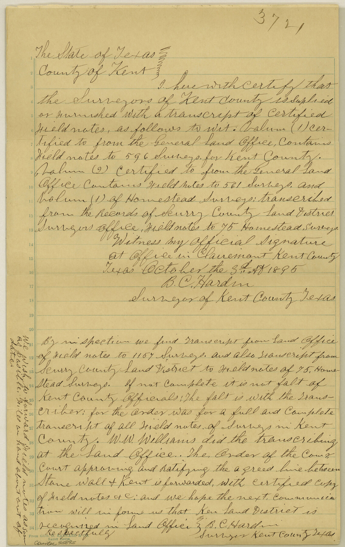
Kent County Boundary File 11
Certificate in regards to Records filed in the General Land Office Octob. 7th, 1895
-
Map/Doc
55895
-
Collection
General Map Collection
-
Counties
Kent
-
Subjects
County Boundaries
-
Height x Width
13.9 x 8.8 inches
35.3 x 22.4 cm
Part of: General Map Collection
Tyler County Sketch File 18

Print $4.00
- Digital $50.00
Tyler County Sketch File 18
1879
Size 8.2 x 8.7 inches
Map/Doc 38668

Presidio County Working Sketch 128

Print $20.00
- Digital $50.00
Presidio County Working Sketch 128
1987
Size 37.3 x 29.0 inches
Map/Doc 71806
Wilbarger County Rolled Sketch 3

Print $40.00
- Digital $50.00
Wilbarger County Rolled Sketch 3
Size 39.5 x 67.4 inches
Map/Doc 10141
Kent County Boundary File 9

Print $8.00
- Digital $50.00
Kent County Boundary File 9
Size 14.1 x 8.8 inches
Map/Doc 55883
History of the Geography of Texas

Print $40.00
- Digital $50.00
History of the Geography of Texas
1897
Size 70.7 x 52.9 inches
Map/Doc 3095
Scurry County Rolled Sketch 2

Print $20.00
- Digital $50.00
Scurry County Rolled Sketch 2
Size 44.0 x 44.9 inches
Map/Doc 9911

Liberty County Sketch File 23

Print $4.00
- Digital $50.00
Liberty County Sketch File 23
1859
Size 10.0 x 8.2 inches
Map/Doc 29934
Uvalde County Working Sketch 2

Print $20.00
- Digital $50.00
Uvalde County Working Sketch 2
1911
Size 23.3 x 21.3 inches
Map/Doc 72072
Coke County Sketch File 19

Print $20.00
- Digital $50.00
Coke County Sketch File 19
Size 18.5 x 25.0 inches
Map/Doc 11110
Harrison County Boundary File 2

Print $40.00
- Digital $50.00
Harrison County Boundary File 2
Size 22.6 x 7.7 inches
Map/Doc 54416
You may also like
Terry County Sketch File 10

Print $20.00
- Digital $50.00
Terry County Sketch File 10
Size 10.8 x 43.2 inches
Map/Doc 10394
Laguna Madre from Lone Palmetto Triangulation Station to Gum Pen Triangulation Station

Print $20.00
- Digital $50.00
Laguna Madre from Lone Palmetto Triangulation Station to Gum Pen Triangulation Station
1881
Size 16.2 x 27.5 inches
Map/Doc 73497
Carte d'une partie des Côtes de l'Inde depuis Bombay jus'qu'a Surate, avec le détail des Habitations de cette Côte

Print $20.00
- Digital $50.00
Carte d'une partie des Côtes de l'Inde depuis Bombay jus'qu'a Surate, avec le détail des Habitations de cette Côte
1782
Size 13.2 x 18.2 inches
Map/Doc 97119
Pecos County Rolled Sketch 112

Print $20.00
- Digital $50.00
Pecos County Rolled Sketch 112
1941
Size 39.0 x 37.0 inches
Map/Doc 9720
Brewster County Rolled Sketch 60

Print $40.00
- Digital $50.00
Brewster County Rolled Sketch 60
Size 37.1 x 68.9 inches
Map/Doc 8485
Map of Orange County

Print $20.00
- Digital $50.00
Map of Orange County
1886
Size 17.1 x 17.6 inches
Map/Doc 3931
Current Miscellaneous File 44

Print $10.00
- Digital $50.00
Current Miscellaneous File 44
1954
Size 11.3 x 8.8 inches
Map/Doc 73985
Sketch of a portion of the Texas Coast showing the relative positions of different harbours with the interior Military Posts, and the roads communicating with them, also two new routes from Black Point and Lamar to San Antonio

Print $20.00
- Digital $50.00
Sketch of a portion of the Texas Coast showing the relative positions of different harbours with the interior Military Posts, and the roads communicating with them, also two new routes from Black Point and Lamar to San Antonio
1855
Size 27.3 x 18.3 inches
Map/Doc 72710
Flight Mission No. BRA-3M, Frame 199, Jefferson County

Print $20.00
- Digital $50.00
Flight Mission No. BRA-3M, Frame 199, Jefferson County
1953
Size 18.6 x 22.3 inches
Map/Doc 85414
Flight Mission No. BQR-9K, Frame 51, Brazoria County

Print $20.00
- Digital $50.00
Flight Mission No. BQR-9K, Frame 51, Brazoria County
1952
Size 18.9 x 22.4 inches
Map/Doc 84055

Flight Mission No. BRA-7M, Frame 128, Jefferson County

Print $20.00
- Digital $50.00
Flight Mission No. BRA-7M, Frame 128, Jefferson County
1953
Size 18.8 x 22.5 inches
Map/Doc 85522