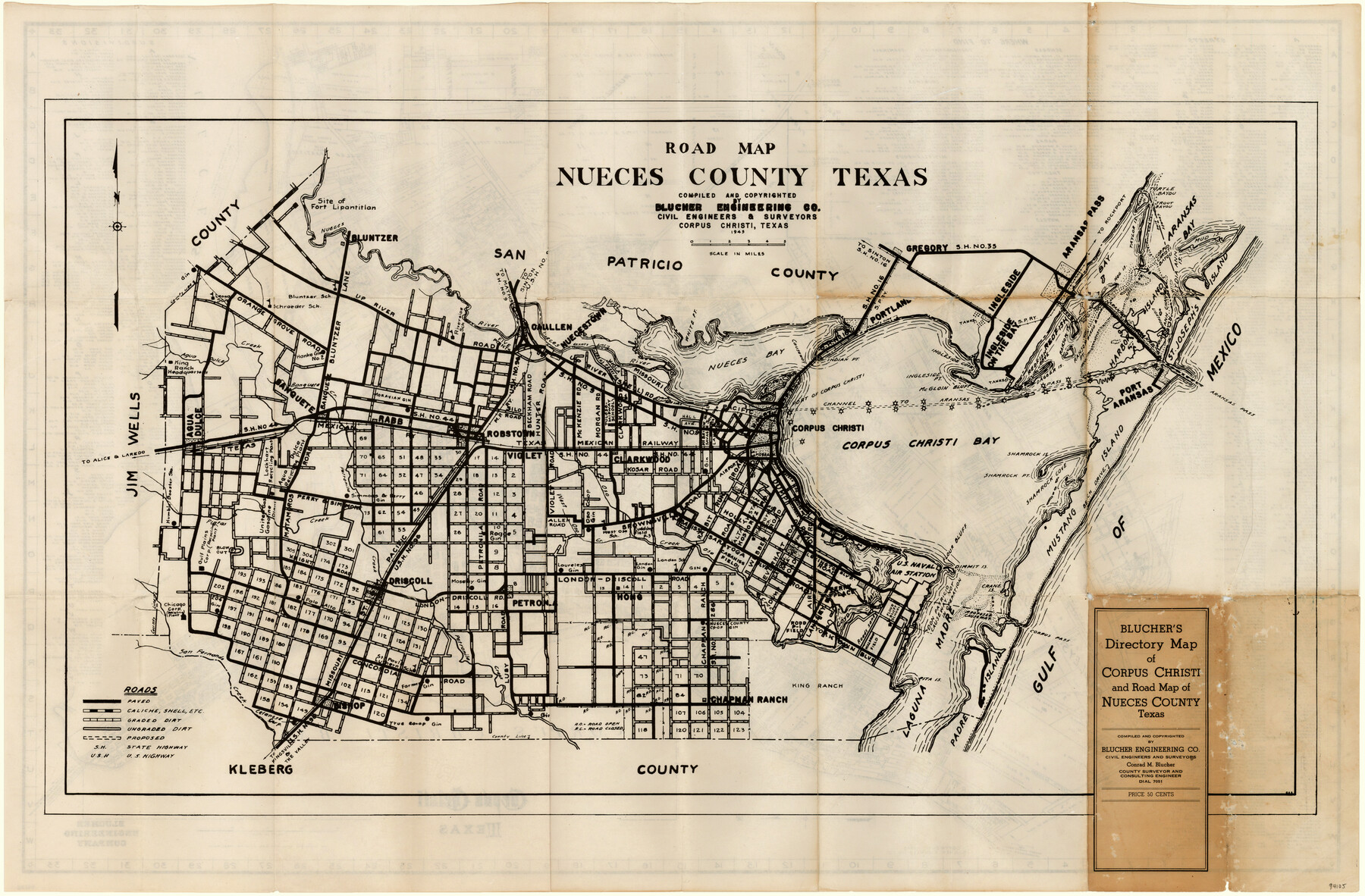
Blucher's Directory Map of Corpus Christi and Road Map of Nueces County
Road Map Nueces County, Texas
-
Map/Doc
94105
-
Collection
General Map Collection
-
Object Dates
1945 (Creation Date)
1945 (Copyright Date)
-
People and Organizations
Blucher Engineering Company (Publisher)
Conrad M. Blucher (Surveyor/Engineer)
-
Counties
Nueces
-
Subjects
County
-
Height x Width
22.7 x 34.4 inches
57.7 x 87.4 cm
-
Medium
paper, etching/engraving/lithograph
-
Comments
See 94106 for a map of Corpus Christi on verso.
-
Features
[Road] to Alice
Flour Bluff
U.S. Naval Air Station
London School
Brownsville Road
West Oso School
Oso Creek
West Oso Creek
Petranila Creek
Pintas Creek
[Road] to Laredo
Dimmit Island
King Ranch Headquarters
Agua Dulce Creek
Banquete
Banquete Creek
Robstown
Rabb
State Highway No. 44
MP
McGloin Bluff
Driscoll Road
Pita Island
King Ranch
Padre Island
Laguna Madre
Bichop
Kleberg
[Road] to the Valley
[Road] to Kingsville
[Road] to Kingsville & the Valley
San Fernando Creek
Ingleside Point
London Road
London-Driscoll Road
Flour Bluff School
Crane Island
Corpus Pass
Mustang Island
Shamrock Point
Shamrock Cove
Shamrock Island
Calallen
Southern Pacific Railroad Company
Gregory
Ingleside Cove
[Road] to Sinton
Portland
State Highway No. 16
Indian Point
Nueces Bay
White Point
Nuecestown
[Road] to Rockport
U.S. Highway No. 96
[Road] to Mathis
State Highway No. 9
Riverside School
Leona School
Schroeder School
Bluntzer School
Bluntzer
Nueces River
Lydia Ann Channel
Ingleside on the Bay
Ingleside
Lighthouse
Redfish Cove
Dagger Island
Harbor Island
Ransom Point
Ransom Island
St. Joseph's Island
Fort Lipantitlan
Lydia Ann Island
Mud Island
Aransas Bay
Corpus Christi Bayou
Trout Bayou
Turtle Bayou
Hog Island
Tally Island
Taylor Island
Related maps
Blucher's Directory Map of Corpus Christi and Road Map of Nueces County

Print $20.00
- Digital $50.00
Blucher's Directory Map of Corpus Christi and Road Map of Nueces County
1945
Size 22.6 x 34.3 inches
Map/Doc 94106
Part of: General Map Collection

Presidio County Working Sketch 109

Print $20.00
- Digital $50.00
Presidio County Working Sketch 109
1980
Size 23.3 x 21.4 inches
Map/Doc 71786
E. L. & R. R. RR., Cass Co.

Print $40.00
- Digital $50.00
E. L. & R. R. RR., Cass Co.
1898
Size 13.4 x 65.4 inches
Map/Doc 64244
Williamson County Sketch File 26

Print $30.00
- Digital $50.00
Williamson County Sketch File 26
1853
Size 14.2 x 8.8 inches
Map/Doc 40367
Burleson County Working Sketch 44

Print $20.00
- Digital $50.00
Burleson County Working Sketch 44
1991
Size 22.4 x 25.0 inches
Map/Doc 67763
Childress County Sketch File 11

Print $6.00
- Digital $50.00
Childress County Sketch File 11
Size 14.0 x 8.6 inches
Map/Doc 18253
Martin County Rolled Sketch 9

Print $20.00
- Digital $50.00
Martin County Rolled Sketch 9
1990
Size 17.3 x 11.4 inches
Map/Doc 6669
[Surveys along the Polk and Tyler County border]
![333, [Surveys along the Polk and Tyler County border], General Map Collection](https://historictexasmaps.com/wmedia_w700/maps/333.tif.jpg)
Print $2.00
- Digital $50.00
[Surveys along the Polk and Tyler County border]
Size 9.3 x 6.0 inches
Map/Doc 333
Fractional Township No. 9 South Range No. 23 East of the Indian Meridian, Indian Territory

Print $20.00
- Digital $50.00
Fractional Township No. 9 South Range No. 23 East of the Indian Meridian, Indian Territory
1898
Size 19.2 x 24.4 inches
Map/Doc 75240
Henderson County Working Sketch 43

Print $20.00
- Digital $50.00
Henderson County Working Sketch 43
1994
Size 36.7 x 39.0 inches
Map/Doc 66176
Trinity County Working Sketch 7a

Print $20.00
- Digital $50.00
Trinity County Working Sketch 7a
1933
Size 39.7 x 27.3 inches
Map/Doc 69455
Flight Mission No. CLL-1N, Frame 17, Willacy County

Print $20.00
- Digital $50.00
Flight Mission No. CLL-1N, Frame 17, Willacy County
1954
Size 18.5 x 22.1 inches
Map/Doc 87004
You may also like
[State Line from Southeast New Mexico to Yoakum County]
![92013, [State Line from Southeast New Mexico to Yoakum County], Twichell Survey Records](https://historictexasmaps.com/wmedia_w700/maps/92013-1.tif.jpg)
Print $20.00
- Digital $50.00
[State Line from Southeast New Mexico to Yoakum County]
Size 32.3 x 11.7 inches
Map/Doc 92013
Leon County Working Sketch 9

Print $20.00
- Digital $50.00
Leon County Working Sketch 9
1949
Size 16.7 x 18.1 inches
Map/Doc 70408
Real County Working Sketch 1

Print $20.00
- Digital $50.00
Real County Working Sketch 1
Size 16.5 x 18.8 inches
Map/Doc 71893
Clay County Boundary File 19

Print $8.00
- Digital $50.00
Clay County Boundary File 19
1924
Size 3.3 x 5.5 inches
Map/Doc 65511
Motley County Sketch File 38 (N)

Print $106.00
- Digital $50.00
Motley County Sketch File 38 (N)
1910
Size 14.4 x 8.8 inches
Map/Doc 32086
Hemphill County Working Sketch 18

Print $20.00
- Digital $50.00
Hemphill County Working Sketch 18
1972
Size 33.7 x 41.6 inches
Map/Doc 66113
Denton County Boundary File 4 and 4a and 4b and 4c

Print $2.00
- Digital $50.00
Denton County Boundary File 4 and 4a and 4b and 4c
Size 11.0 x 8.7 inches
Map/Doc 52470
Austin, Texas Congress Ave. Drainage

Print $20.00
- Digital $50.00
Austin, Texas Congress Ave. Drainage
1903
Size 15.1 x 15.5 inches
Map/Doc 75797
Bandera County Rolled Sketch 1

Print $20.00
- Digital $50.00
Bandera County Rolled Sketch 1
1945
Size 16.5 x 16.0 inches
Map/Doc 5113
Amistad International Reservoir on Rio Grande 99

Print $20.00
- Digital $50.00
Amistad International Reservoir on Rio Grande 99
1950
Size 28.4 x 40.7 inches
Map/Doc 75530
Sutton County Rolled Sketch 59

Print $40.00
- Digital $50.00
Sutton County Rolled Sketch 59
1960
Size 86.1 x 42.5 inches
Map/Doc 9977
Stephens County Sketch File 6

Print $4.00
- Digital $50.00
Stephens County Sketch File 6
Size 9.1 x 9.1 inches
Map/Doc 37021