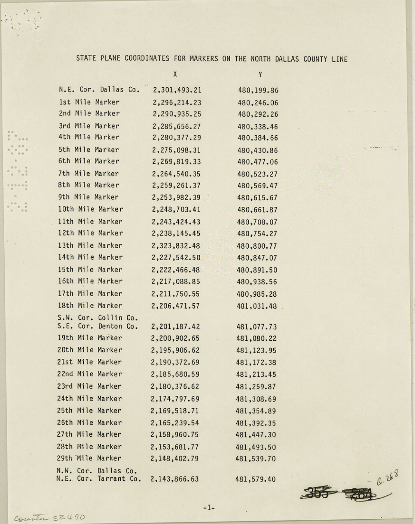
Denton County Boundary File 4 and 4a and 4b and 4c
[Court Order , field notes, and map of north Dallas County line]
-
Map/Doc
52470
-
Collection
General Map Collection
-
Counties
Denton
-
Subjects
County Boundaries
-
Height x Width
11.0 x 8.7 inches
27.9 x 22.1 cm
Part of: General Map Collection
El Paso County Working Sketch 32

Print $20.00
- Digital $50.00
El Paso County Working Sketch 32
1971
Size 40.2 x 38.3 inches
Map/Doc 69054
Webb County Sketch File 10-1

Print $20.00
- Digital $50.00
Webb County Sketch File 10-1
1850
Size 14.8 x 15.5 inches
Map/Doc 12625
[Sketch for Mineral Application 24072, San Jacinto River]
![65604, [Sketch for Mineral Application 24072, San Jacinto River], General Map Collection](https://historictexasmaps.com/wmedia_w700/maps/65604.tif.jpg)
Print $20.00
- Digital $50.00
[Sketch for Mineral Application 24072, San Jacinto River]
1929
Size 23.3 x 17.5 inches
Map/Doc 65604
Presidio County Boundary File 3a

Print $40.00
- Digital $50.00
Presidio County Boundary File 3a
Size 17.7 x 38.0 inches
Map/Doc 58074
[Plat of Location and Right of Way from El Paso, Tex. To New Mexico Line, Rio Grande and El Paso R. R.]
![64084, [Plat of Location and Right of Way from El Paso, Tex. To New Mexico Line, Rio Grande and El Paso R. R.], General Map Collection](https://historictexasmaps.com/wmedia_w700/maps/64084.tif.jpg)
Print $20.00
- Digital $50.00
[Plat of Location and Right of Way from El Paso, Tex. To New Mexico Line, Rio Grande and El Paso R. R.]
Size 22.7 x 46.8 inches
Map/Doc 64084
Hartley County Boundary File 3

Print $15.00
- Digital $50.00
Hartley County Boundary File 3
Size 6.7 x 16.5 inches
Map/Doc 54476
La Salle County Rolled Sketch 14

Print $20.00
- Digital $50.00
La Salle County Rolled Sketch 14
Size 22.3 x 24.8 inches
Map/Doc 6577
Coleman County Rolled Sketch 6

Print $20.00
- Digital $50.00
Coleman County Rolled Sketch 6
Size 20.9 x 14.4 inches
Map/Doc 5529
Flight Mission No. CGI-3N, Frame 43, Cameron County

Print $20.00
- Digital $50.00
Flight Mission No. CGI-3N, Frame 43, Cameron County
1954
Size 18.5 x 22.1 inches
Map/Doc 84549
Hudspeth County Sketch File 19

Print $4.00
- Digital $50.00
Hudspeth County Sketch File 19
1901
Size 11.3 x 8.8 inches
Map/Doc 26962
Harris County Sketch File 56a

Print $54.00
- Digital $50.00
Harris County Sketch File 56a
1912
Size 9.0 x 7.9 inches
Map/Doc 25456
Edwards County Working Sketch 67

Print $20.00
- Digital $50.00
Edwards County Working Sketch 67
1957
Size 38.3 x 44.2 inches
Map/Doc 68943
You may also like
Upton County Boundary File 1a

Print $27.00
- Digital $50.00
Upton County Boundary File 1a
Size 13.6 x 9.1 inches
Map/Doc 59508
[Galveston, Harrisburg & San Antonio Railway]
![64406, [Galveston, Harrisburg & San Antonio Railway], General Map Collection](https://historictexasmaps.com/wmedia_w700/maps/64406.tif.jpg)
Print $20.00
- Digital $50.00
[Galveston, Harrisburg & San Antonio Railway]
1892
Size 13.5 x 33.6 inches
Map/Doc 64406
Flight Mission No. DIX-7P, Frame 87, Aransas County

Print $20.00
- Digital $50.00
Flight Mission No. DIX-7P, Frame 87, Aransas County
1956
Size 18.7 x 22.4 inches
Map/Doc 83881
Sketch in Atascosa County

Print $3.00
- Digital $50.00
Sketch in Atascosa County
1890
Size 12.6 x 11.4 inches
Map/Doc 578
Matagorda County Aerial Photograph Index Sheet 6

Print $20.00
- Digital $50.00
Matagorda County Aerial Photograph Index Sheet 6
1953
Size 23.8 x 19.6 inches
Map/Doc 83727
Webb County Working Sketch 32

Print $20.00
- Digital $50.00
Webb County Working Sketch 32
1937
Size 34.5 x 36.0 inches
Map/Doc 72397
Newton County Working Sketch 30

Print $20.00
- Digital $50.00
Newton County Working Sketch 30
1955
Size 18.2 x 17.8 inches
Map/Doc 71276
County School Lands

Print $3.00
- Digital $50.00
County School Lands
1913
Size 10.4 x 14.2 inches
Map/Doc 90450
Van Zandt County Working Sketch 14

Print $20.00
- Digital $50.00
Van Zandt County Working Sketch 14
1982
Size 13.2 x 11.5 inches
Map/Doc 72264
Kent County Boundary File 7

Print $6.00
- Digital $50.00
Kent County Boundary File 7
Size 10.8 x 8.7 inches
Map/Doc 55870
Andrews County Sketch File 3

Print $46.00
- Digital $50.00
Andrews County Sketch File 3
1928
Size 33.0 x 36.6 inches
Map/Doc 10317
Map of the City of Austin

Print $20.00
Map of the City of Austin
1910
Size 24.0 x 18.0 inches
Map/Doc 90071