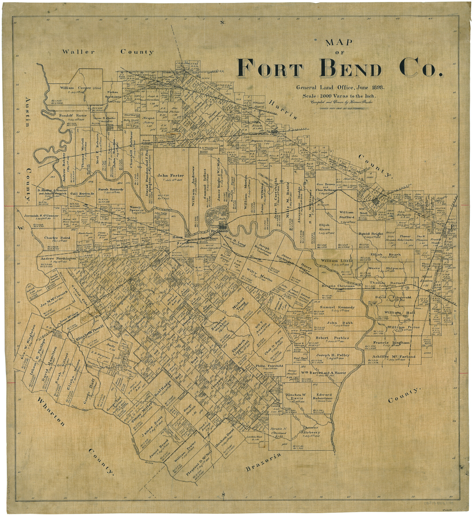
Map of Fort Bend Co.
-
Map/Doc
75965
-
Collection
General Map Collection
-
Object Dates
6/1898 (Creation Date)
5/1914 (Tracing Date)
-
People and Organizations
Texas General Land Office (Publisher)
Herman Pressler (Draftsman)
Otis O. Terrell (Tracer)
-
Counties
Fort Bend
-
Subjects
County
-
Height x Width
45.1 x 41.1 inches
114.6 x 104.4 cm
Part of: General Map Collection
Ellis County Boundary File 67 1/2

Print $24.00
- Digital $50.00
Ellis County Boundary File 67 1/2
Size 9.0 x 4.1 inches
Map/Doc 53003
Hockley County

Print $20.00
- Digital $50.00
Hockley County
1897
Size 19.1 x 20.5 inches
Map/Doc 3675
Randall County Sketch File 10

Print $4.00
- Digital $50.00
Randall County Sketch File 10
1941
Size 11.4 x 8.8 inches
Map/Doc 34972
Flight Mission No. DQO-2K, Frame 94, Galveston County

Print $20.00
- Digital $50.00
Flight Mission No. DQO-2K, Frame 94, Galveston County
1952
Size 18.7 x 22.4 inches
Map/Doc 85021
Flight Mission No. CUG-3P, Frame 167, Kleberg County

Print $20.00
- Digital $50.00
Flight Mission No. CUG-3P, Frame 167, Kleberg County
1956
Size 18.6 x 22.4 inches
Map/Doc 86287
Lubbock County Boundary File 8

Print $46.00
- Digital $50.00
Lubbock County Boundary File 8
Size 7.3 x 8.7 inches
Map/Doc 56525
Oldham County

Print $40.00
- Digital $50.00
Oldham County
1925
Size 41.5 x 53.2 inches
Map/Doc 95604
Jones County Working Sketch 1

Print $20.00
- Digital $50.00
Jones County Working Sketch 1
Size 21.1 x 11.2 inches
Map/Doc 66639
Jasper County

Print $40.00
- Digital $50.00
Jasper County
1898
Size 64.2 x 35.6 inches
Map/Doc 78413
Flight Mission No. DAG-22K, Frame 73, Matagorda County

Print $20.00
- Digital $50.00
Flight Mission No. DAG-22K, Frame 73, Matagorda County
1953
Size 18.7 x 22.4 inches
Map/Doc 86460
Supplemental Plat, T. 4S., R. 14W., Indian Meridian, Oklahoma

Print $4.00
- Digital $50.00
Supplemental Plat, T. 4S., R. 14W., Indian Meridian, Oklahoma
1926
Size 18.1 x 23.6 inches
Map/Doc 75149
Houston & Great Northern R.R. from Troupe in Smith Co. the point of junction with International R.R. to Mineola in Wood Co. the point of junction with T. & P. R.R.

Print $22.00
- Digital $50.00
Houston & Great Northern R.R. from Troupe in Smith Co. the point of junction with International R.R. to Mineola in Wood Co. the point of junction with T. & P. R.R.
1873
Size 21.2 x 8.6 inches
Map/Doc 64301
You may also like
Map of the Globe showing its continents, islands, mountain ranges, table lands, plains and slopes

Print $20.00
- Digital $50.00
Map of the Globe showing its continents, islands, mountain ranges, table lands, plains and slopes
1885
Size 12.2 x 18.5 inches
Map/Doc 93532
Harris County Historic Topographic 29

Print $20.00
- Digital $50.00
Harris County Historic Topographic 29
1915
Size 29.1 x 23.0 inches
Map/Doc 65840
Tyler County Working Sketch 25

Print $20.00
- Digital $50.00
Tyler County Working Sketch 25
1909
Size 29.8 x 26.7 inches
Map/Doc 69495
Limestone County Sketch File 28

Print $54.00
- Digital $50.00
Limestone County Sketch File 28
1986
Size 11.2 x 8.5 inches
Map/Doc 30216
Harris County Sketch File 93

Print $20.00
- Digital $50.00
Harris County Sketch File 93
1952
Size 33.0 x 14.5 inches
Map/Doc 11676
Lavaca County Working Sketch 11

Print $20.00
- Digital $50.00
Lavaca County Working Sketch 11
1954
Size 34.0 x 28.3 inches
Map/Doc 70364
Brewster County Working Sketch 100

Print $40.00
- Digital $50.00
Brewster County Working Sketch 100
1979
Size 41.0 x 55.2 inches
Map/Doc 67700
Fannin County Boundary File 2

Print $27.00
- Digital $50.00
Fannin County Boundary File 2
Size 13.4 x 8.8 inches
Map/Doc 53282
Donley County Sketch File 30

Print $24.00
- Digital $50.00
Donley County Sketch File 30
1906
Size 11.3 x 8.7 inches
Map/Doc 21270
San Jacinto County Working Sketch 12

Print $20.00
- Digital $50.00
San Jacinto County Working Sketch 12
1935
Size 33.4 x 37.3 inches
Map/Doc 63725
Presidio County Rolled Sketch 84

Print $20.00
- Digital $50.00
Presidio County Rolled Sketch 84
1942
Size 22.7 x 33.1 inches
Map/Doc 9779
[H. & T. C. Block 47, Sections 52- 56]
![91488, [H. & T. C. Block 47, Sections 52- 56], Twichell Survey Records](https://historictexasmaps.com/wmedia_w700/maps/91488-1.tif.jpg)
Print $3.00
- Digital $50.00
[H. & T. C. Block 47, Sections 52- 56]
Size 9.4 x 14.4 inches
Map/Doc 91488