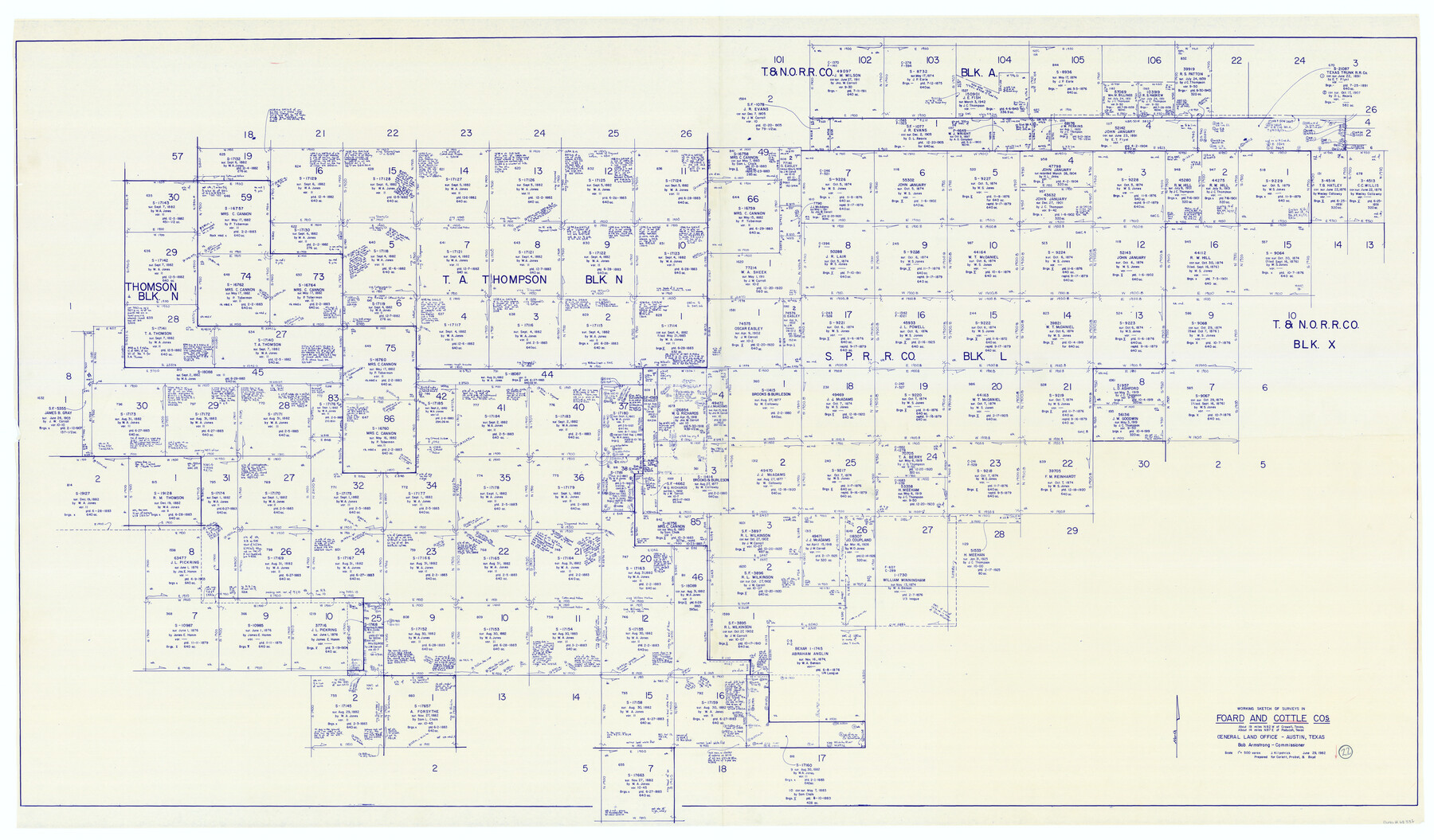
Cottle County Working Sketch 22
-
Map/Doc
68332
-
Collection
General Map Collection
-
Object Dates
6/29/1982 (Creation Date)
-
People and Organizations
Joan Kilpatrick (Draftsman)
-
Counties
Cottle Foard
-
Subjects
Surveying Working Sketch
-
Height x Width
44.0 x 75.0 inches
111.8 x 190.5 cm
-
Scale
1" = 500 varas
Part of: General Map Collection
Flight Mission No. DIX-6P, Frame 198, Aransas County

Print $20.00
- Digital $50.00
Flight Mission No. DIX-6P, Frame 198, Aransas County
1956
Size 19.1 x 22.9 inches
Map/Doc 83860
Map of the West Part of Tom Green County

Print $20.00
- Digital $50.00
Map of the West Part of Tom Green County
1894
Size 46.9 x 34.7 inches
Map/Doc 63072
Right-of-Way and Track Map, Texas State Railroad operated by the T. and N. O. R.R. Co.

Print $40.00
- Digital $50.00
Right-of-Way and Track Map, Texas State Railroad operated by the T. and N. O. R.R. Co.
1917
Size 24.8 x 56.3 inches
Map/Doc 64173
Austin County Working Sketch 9

Print $20.00
- Digital $50.00
Austin County Working Sketch 9
1996
Size 34.4 x 32.0 inches
Map/Doc 67250
Crockett County Working Sketch 95

Print $20.00
- Digital $50.00
Crockett County Working Sketch 95
1979
Size 26.6 x 47.2 inches
Map/Doc 68428
Flight Mission No. BRA-3M, Frame 126, Jefferson County

Print $20.00
- Digital $50.00
Flight Mission No. BRA-3M, Frame 126, Jefferson County
1953
Size 18.7 x 21.8 inches
Map/Doc 85400
Cooke County Working Sketch 11
Print $20.00
- Digital $50.00
Cooke County Working Sketch 11
1940
Size 42.6 x 28.2 inches
Map/Doc 68248
Flight Mission No. DQN-2K, Frame 91, Calhoun County

Print $20.00
- Digital $50.00
Flight Mission No. DQN-2K, Frame 91, Calhoun County
1953
Size 18.8 x 22.4 inches
Map/Doc 84281
El Paso County Rolled Sketch 63

Print $20.00
- Digital $50.00
El Paso County Rolled Sketch 63
1996
Size 24.7 x 36.8 inches
Map/Doc 5855
Webb County Rolled Sketch 56

Print $20.00
- Digital $50.00
Webb County Rolled Sketch 56
1945
Size 22.2 x 23.7 inches
Map/Doc 8208
Neches River, Blackburn Bridge Sheet

Print $4.00
- Digital $50.00
Neches River, Blackburn Bridge Sheet
1938
Size 27.6 x 20.5 inches
Map/Doc 65083
Fayette County

Print $40.00
- Digital $50.00
Fayette County
1920
Size 42.7 x 49.8 inches
Map/Doc 4945
You may also like
Cottle County

Print $20.00
- Digital $50.00
Cottle County
1908
Size 45.0 x 41.0 inches
Map/Doc 66789

Karnes County Boundary File 3

Print $26.00
- Digital $50.00
Karnes County Boundary File 3
Size 12.7 x 8.3 inches
Map/Doc 55694
Map of Titus County

Print $20.00
- Digital $50.00
Map of Titus County
1860
Size 20.9 x 21.8 inches
Map/Doc 4081
[Sketch for Mineral Application 24072, San Jacinto River]
![65593, [Sketch for Mineral Application 24072, San Jacinto River], General Map Collection](https://historictexasmaps.com/wmedia_w700/maps/65593.tif.jpg)
Print $20.00
- Digital $50.00
[Sketch for Mineral Application 24072, San Jacinto River]
1929
Size 19.1 x 16.9 inches
Map/Doc 65593
Flight Mission No. CRK-3P, Frame 65, Refugio County

Print $20.00
- Digital $50.00
Flight Mission No. CRK-3P, Frame 65, Refugio County
1956
Size 18.5 x 22.4 inches
Map/Doc 86907
[Map of Texas and Pacific Blocks from Brazos River westward through Palo Pinto, Stephens, Shackelford, Jones, Callahan, Taylor, Fisher, Nolan and Mitchell Counties]
![93457, [Map of Texas and Pacific Blocks from Brazos River westward through Palo Pinto, Stephens, Shackelford, Jones, Callahan, Taylor, Fisher, Nolan and Mitchell Counties], General Map Collection](https://historictexasmaps.com/wmedia_w700/maps/93457-1.tif.jpg)
Print $20.00
- Digital $50.00
[Map of Texas and Pacific Blocks from Brazos River westward through Palo Pinto, Stephens, Shackelford, Jones, Callahan, Taylor, Fisher, Nolan and Mitchell Counties]
Size 35.0 x 19.3 inches
Map/Doc 93457
Old Miscellaneous File 38

Print $40.00
- Digital $50.00
Old Miscellaneous File 38
Size 58.2 x 33.7 inches
Map/Doc 75283
Jeff Davis County Working Sketch Graphic Index - central part

Print $40.00
- Digital $50.00
Jeff Davis County Working Sketch Graphic Index - central part
1982
Size 55.7 x 42.6 inches
Map/Doc 76593
Floyd County Sketch File 24

Print $6.00
- Digital $50.00
Floyd County Sketch File 24
1915
Size 9.0 x 14.5 inches
Map/Doc 22780
Limestone County Sketch File 19

Print $4.00
- Digital $50.00
Limestone County Sketch File 19
1922
Size 11.0 x 8.7 inches
Map/Doc 30193
Section H Tech Memorial Park, Inc.

Print $20.00
- Digital $50.00
Section H Tech Memorial Park, Inc.
Size 18.0 x 11.3 inches
Map/Doc 92302