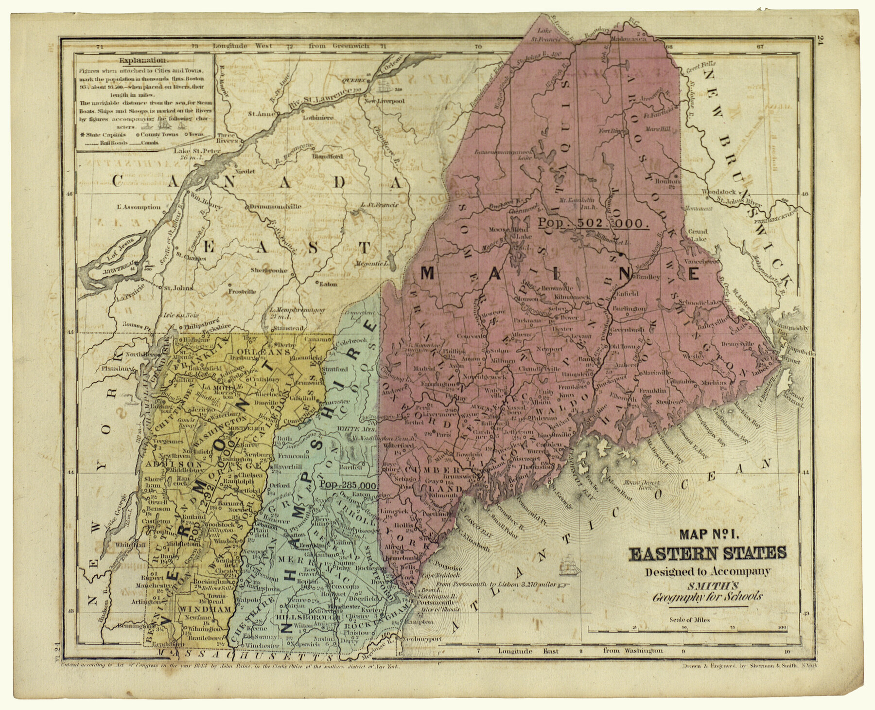
Map No. 1. Eastern States designed to accompany Smith's Geography for School
-
Map/Doc
93885
-
Collection
Holcomb Digital Map Collection
-
Object Dates
1850 (Creation Date)
-
People and Organizations
Sherman and Smith (Printer)
Sherman and Smith (Draftsman)
-
Subjects
Atlas
-
Height x Width
9.8 x 12.1 inches
24.9 x 30.7 cm
-
Comments
Courtesy of Frank and Carol Holcomb.
Part of: Holcomb Digital Map Collection
A Map of Louisiana and Mexico

Print $20.00
- Digital $50.00
A Map of Louisiana and Mexico
1820
Size 43.8 x 32.9 inches
Map/Doc 94945
A new & correct map of Texas compiled from the most recent surveys & authorities to the year 1845

Print $20.00
- Digital $50.00
A new & correct map of Texas compiled from the most recent surveys & authorities to the year 1845
1845
Size 22.4 x 28.5 inches
Map/Doc 96973
A New Map of Texas

Print $20.00
- Digital $50.00
A New Map of Texas
1841
Size 17.6 x 16.2 inches
Map/Doc 93862
L'Amerique Meridionale et Septentrionale

Print $20.00
- Digital $50.00
L'Amerique Meridionale et Septentrionale
1731
Size 20.0 x 28.3 inches
Map/Doc 93825
North America corrected from the observations communicated to the Royal Society at London and the Royal Academy at Paris

Print $20.00
- Digital $50.00
North America corrected from the observations communicated to the Royal Society at London and the Royal Academy at Paris
1710
Size 38.9 x 26.9 inches
Map/Doc 93820
Map of Texas compiled from surveys at the Land Office of Texas

Print $20.00
- Digital $50.00
Map of Texas compiled from surveys at the Land Office of Texas
1851
Size 26.7 x 19.1 inches
Map/Doc 96431
Amerique Septentrionale divisée en ses principales parties

Print $20.00
- Digital $50.00
Amerique Septentrionale divisée en ses principales parties
1792
Size 21.3 x 25.9 inches
Map/Doc 93916
Perry and Spaulding's American Republic and Railroad Map of the United States and of the Dominion of Canada

Print $40.00
- Digital $50.00
Perry and Spaulding's American Republic and Railroad Map of the United States and of the Dominion of Canada
1874
Size 40.5 x 55.7 inches
Map/Doc 93913
Novissima et Accuratissima Totius Americae Descriptio

Print $20.00
- Digital $50.00
Novissima et Accuratissima Totius Americae Descriptio
1677
Size 20.9 x 25.0 inches
Map/Doc 93819
Texas Nach den besten Quellen

Print $20.00
- Digital $50.00
Texas Nach den besten Quellen
1846
Size 15.4 x 18.7 inches
Map/Doc 93874
A Map of the United States including Louisiana

Print $20.00
- Digital $50.00
A Map of the United States including Louisiana
1817
Size 14.9 x 18.2 inches
Map/Doc 95964
Map of the United States and Canada

Print $2.00
- Digital $50.00
Map of the United States and Canada
1853
Size 6.2 x 4.2 inches
Map/Doc 93919
You may also like
Chambers County NRC Article 33.136 Sketch 3

Print $21.00
- Digital $50.00
Chambers County NRC Article 33.136 Sketch 3
2005
Size 25.0 x 36.8 inches
Map/Doc 83595
Kimble County Sketch File 34

Print $20.00
- Digital $50.00
Kimble County Sketch File 34
1963
Size 26.2 x 16.3 inches
Map/Doc 11931
Val Verde County Working Sketch 117

Print $20.00
- Digital $50.00
Val Verde County Working Sketch 117
1993
Size 33.8 x 37.0 inches
Map/Doc 82842
[Galveston, Harrisburg & San Antonio Railroad from Cuero to Stockdale]
![64188, [Galveston, Harrisburg & San Antonio Railroad from Cuero to Stockdale], General Map Collection](https://historictexasmaps.com/wmedia_w700/maps/64188.tif.jpg)
Print $20.00
- Digital $50.00
[Galveston, Harrisburg & San Antonio Railroad from Cuero to Stockdale]
1907
Size 13.8 x 34.0 inches
Map/Doc 64188
Howard County Working Sketch 7a

Print $40.00
- Digital $50.00
Howard County Working Sketch 7a
1950
Size 81.9 x 24.7 inches
Map/Doc 66273
Trinity County Sketch File 36

Print $20.00
- Digital $50.00
Trinity County Sketch File 36
Size 43.4 x 18.1 inches
Map/Doc 10408
Menard County Sketch File 21

Print $40.00
- Digital $50.00
Menard County Sketch File 21
1913
Size 14.1 x 14.8 inches
Map/Doc 31551
Andrews County

Print $40.00
- Digital $50.00
Andrews County
1925
Size 56.5 x 42.8 inches
Map/Doc 89866
Bailey County Sketch File 5

Print $40.00
- Digital $50.00
Bailey County Sketch File 5
1907
Size 31.9 x 22.8 inches
Map/Doc 10883
Burleson County Working Sketch 15

Print $20.00
- Digital $50.00
Burleson County Working Sketch 15
1980
Size 15.0 x 21.1 inches
Map/Doc 67734
Uvalde County Working Sketch 68

Print $20.00
- Digital $50.00
Uvalde County Working Sketch 68
1971
Size 30.3 x 32.0 inches
Map/Doc 75974
Brazoria County Working Sketch 10

Print $20.00
- Digital $50.00
Brazoria County Working Sketch 10
1935
Size 16.2 x 25.2 inches
Map/Doc 67495