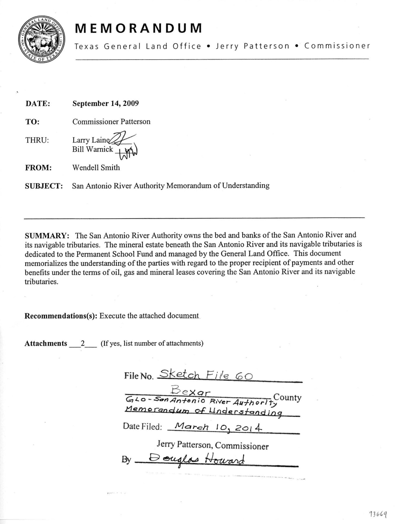
Bexar County Sketch File 60
San Antonio River Authority Memorandum of Understanding regarding exploration and production of oil and gas from beneath the bed and banks of the San Antonio River and its navigable tributaries.
-
Map/Doc
93669
-
Collection
General Map Collection
-
Object Dates
2009/9/16 (Creation Date)
2014/3/10 (File Date)
-
People and Organizations
Jerry E. Patterson (GLO Commissioner)
LaNell Aston (Author)
Wendell Smith (Author)
-
Counties
Bexar Wilson Karnes Goliad
-
Subjects
Surveying Sketch File
-
Height x Width
11.0 x 8.5 inches
27.9 x 21.6 cm
-
Medium
paper, photocopy
-
Features
San Antonio River
Part of: General Map Collection
Red River County Working Sketch 27

Print $20.00
- Digital $50.00
Red River County Working Sketch 27
1961
Size 25.3 x 42.7 inches
Map/Doc 72010
Matagorda County Sketch File 17

Print $20.00
- Digital $50.00
Matagorda County Sketch File 17
1877
Size 16.4 x 14.5 inches
Map/Doc 12040
Map of Texas from the most recent authorities

Print $20.00
- Digital $50.00
Map of Texas from the most recent authorities
1845
Map/Doc 93945
Map accompanying report of scout made by 2nd Lt. F. de I. Carrington. 1st Infantry

Print $20.00
- Digital $50.00
Map accompanying report of scout made by 2nd Lt. F. de I. Carrington. 1st Infantry
1881
Size 22.2 x 18.0 inches
Map/Doc 65407
Flight Mission No. BRA-16M, Frame 131, Jefferson County

Print $20.00
- Digital $50.00
Flight Mission No. BRA-16M, Frame 131, Jefferson County
1953
Size 18.4 x 22.5 inches
Map/Doc 85741
Tyler County Working Sketch 20

Print $20.00
- Digital $50.00
Tyler County Working Sketch 20
1982
Size 41.0 x 32.7 inches
Map/Doc 69490
Travis County Sketch File 45

Print $20.00
- Digital $50.00
Travis County Sketch File 45
1937
Size 22.7 x 37.8 inches
Map/Doc 12467
Lynn County Boundary File 6a

Print $2.00
- Digital $50.00
Lynn County Boundary File 6a
Size 11.2 x 8.7 inches
Map/Doc 56641

Crockett County Sketch File 82

Print $8.00
- Digital $50.00
Crockett County Sketch File 82
1940
Size 11.3 x 8.7 inches
Map/Doc 19895
Jackson County Working Sketch 7

Print $20.00
- Digital $50.00
Jackson County Working Sketch 7
1973
Size 35.7 x 27.1 inches
Map/Doc 66455
Austin County Sketch File 16

Print $74.00
- Digital $50.00
Austin County Sketch File 16
Size 14.3 x 8.8 inches
Map/Doc 13888
You may also like
Montgomery County Sketch File 14

Print $42.00
- Digital $50.00
Montgomery County Sketch File 14
1905
Size 11.0 x 8.8 inches
Map/Doc 31805
[Strip map showing T. & P. Connecting line from northwest corner Sec. 3, Blk. 33 T5N to northwest corner Sec. 6, Blk. 34 T5N]
![93174, [Strip map showing T. & P. Connecting line from northwest corner Sec. 3, Blk. 33 T5N to northwest corner Sec. 6, Blk. 34 T5N], Twichell Survey Records](https://historictexasmaps.com/wmedia_w700/maps/93174-1.tif.jpg)
Print $40.00
- Digital $50.00
[Strip map showing T. & P. Connecting line from northwest corner Sec. 3, Blk. 33 T5N to northwest corner Sec. 6, Blk. 34 T5N]
1907
Size 7.3 x 77.5 inches
Map/Doc 93174
San Saba County Working Sketch 1

Print $20.00
- Digital $50.00
San Saba County Working Sketch 1
1919
Size 15.3 x 15.3 inches
Map/Doc 63789
Rusk County Sketch File 29

Print $8.00
Rusk County Sketch File 29
1949
Size 11.3 x 8.7 inches
Map/Doc 35554
South Montgomery County, Woodlands Chamber of Commerce Street Map

South Montgomery County, Woodlands Chamber of Commerce Street Map
Size 50.0 x 37.9 inches
Map/Doc 94363
Brazoria County Rolled Sketch 28

Print $40.00
- Digital $50.00
Brazoria County Rolled Sketch 28
Size 35.7 x 56.8 inches
Map/Doc 8458
General Highway Map, Irion County, Texas

Print $20.00
General Highway Map, Irion County, Texas
1940
Size 18.3 x 24.8 inches
Map/Doc 79138
Morris County Rolled Sketch 2A

Print $20.00
- Digital $50.00
Morris County Rolled Sketch 2A
Size 33.5 x 22.8 inches
Map/Doc 10263
Houston County Rolled Sketch 5

Print $20.00
- Digital $50.00
Houston County Rolled Sketch 5
1960
Size 28.3 x 40.8 inches
Map/Doc 6227
Comanche County Rolled Sketch 3

Print $20.00
- Digital $50.00
Comanche County Rolled Sketch 3
2017
Size 35.1 x 44.9 inches
Map/Doc 95384

[Surveys in Austin's Colony along the Yegua River and Cedar Creek]
![67, [Surveys in Austin's Colony along the Yegua River and Cedar Creek], General Map Collection](https://historictexasmaps.com/wmedia_w700/maps/67.tif.jpg)
Print $20.00
- Digital $50.00
[Surveys in Austin's Colony along the Yegua River and Cedar Creek]
1835
Size 15.7 x 19.3 inches
Map/Doc 67