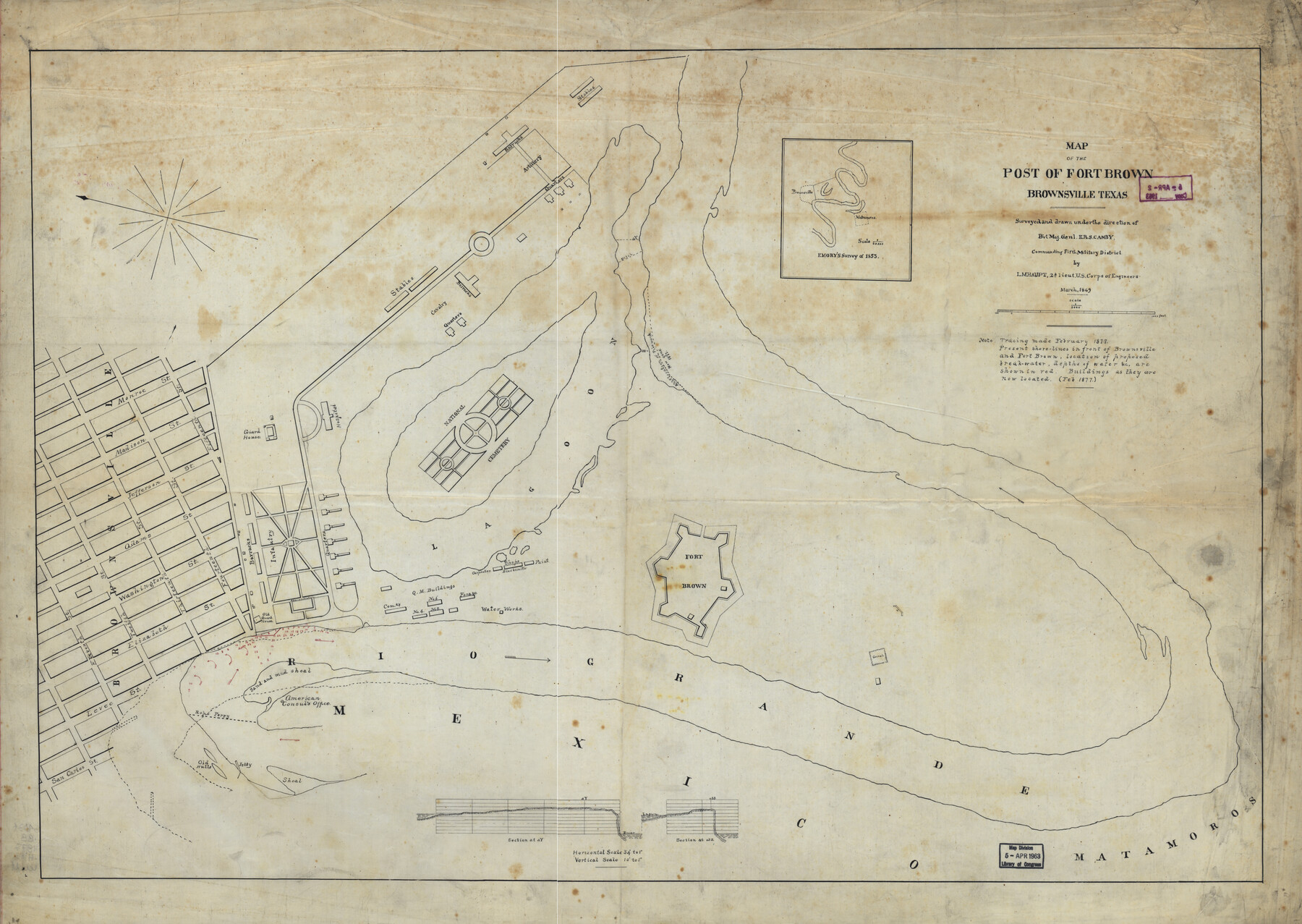
Map of the post of Fort Brown, Brownsville, Texas
-
Map/Doc
93560
-
Collection
Library of Congress
-
Object Dates
2/1877 (Creation Date)
-
People and Organizations
L.M. Haupt (Author)
-
Subjects
City
-
Height x Width
24.0 x 33.9 inches
61.0 x 86.1 cm
-
Comments
For more information see here. Prints available from the GLO courtesy of Library of Congress, Geography and Map Division.
Part of: Library of Congress
[Map showing T&P Lands in El Paso County]
![88934, [Map showing T&P Lands in El Paso County], Library of Congress](https://historictexasmaps.com/wmedia_w700/maps/88934.tif.jpg)
Print $20.00
[Map showing T&P Lands in El Paso County]
Size 17.3 x 22.2 inches
Map/Doc 88934
Denison, Grayson County, Texas, 1891

Print $20.00
Denison, Grayson County, Texas, 1891
1891
Size 23.9 x 36.4 inches
Map/Doc 93480
[Map showing T&P Lands in El Paso County]
![88933, [Map showing T&P Lands in El Paso County], Library of Congress](https://historictexasmaps.com/wmedia_w700/maps/88933.tif.jpg)
Print $20.00
[Map showing T&P Lands in El Paso County]
Size 17.2 x 22.1 inches
Map/Doc 88933
Map of Texas With Parts of the Adjoining States

Print $20.00
Map of Texas With Parts of the Adjoining States
1837
Size 29.9 x 25.2 inches
Map/Doc 88998


Map of Texas With Parts of the Adjoining States

Print $20.00
Map of Texas With Parts of the Adjoining States
1839
Size 35.4 x 25.8 inches
Map/Doc 88995

Map of Jack County, State of Texas : exhibiting the extent of public surveys land grants and all other official information compiled from official surveys of the Genral Land Office at Austin…

Print $20.00
Map of Jack County, State of Texas : exhibiting the extent of public surveys land grants and all other official information compiled from official surveys of the Genral Land Office at Austin…
1876
Size 16.5 x 15.4 inches
Map/Doc 93591
Red River County, Texas

Print $20.00
Red River County, Texas
1870
Size 22.4 x 17.3 inches
Map/Doc 88989

You may also like
Martin-Ameen Addition, City of Lubbock, South 100 Acres of Southeast Quarter, Section 5, Block E

Print $20.00
- Digital $50.00
Martin-Ameen Addition, City of Lubbock, South 100 Acres of Southeast Quarter, Section 5, Block E
Size 30.9 x 24.6 inches
Map/Doc 92737
Red River County Working Sketch 79

Print $40.00
- Digital $50.00
Red River County Working Sketch 79
1986
Size 43.8 x 61.1 inches
Map/Doc 72062
Milam County Working Sketch 7

Print $40.00
- Digital $50.00
Milam County Working Sketch 7
1969
Size 42.7 x 48.0 inches
Map/Doc 71022
Bell County Working Sketch 2

Print $20.00
- Digital $50.00
Bell County Working Sketch 2
1938
Size 25.8 x 28.8 inches
Map/Doc 67342
Menard County Sketch File 16

Print $6.00
- Digital $50.00
Menard County Sketch File 16
1892
Size 12.8 x 8.4 inches
Map/Doc 31513
Harris County Working Sketch 125

Print $20.00
- Digital $50.00
Harris County Working Sketch 125
1995
Size 42.0 x 34.0 inches
Map/Doc 66017
Flight Mission No. CRC-6R, Frame 39, Chambers County

Print $20.00
- Digital $50.00
Flight Mission No. CRC-6R, Frame 39, Chambers County
1956
Size 18.7 x 22.5 inches
Map/Doc 84972
[Surveys in Milam's Colony along the Colorado River and Onion Creek]
![91, [Surveys in Milam's Colony along the Colorado River and Onion Creek], General Map Collection](https://historictexasmaps.com/wmedia_w700/maps/91.tif.jpg)
Print $20.00
- Digital $50.00
[Surveys in Milam's Colony along the Colorado River and Onion Creek]
1835
Size 24.7 x 25.0 inches
Map/Doc 91
Newton County Rolled Sketch 25

Print $20.00
- Digital $50.00
Newton County Rolled Sketch 25
1893
Size 22.3 x 18.6 inches
Map/Doc 6852
Edwards County Sketch File 37

Print $4.00
- Digital $50.00
Edwards County Sketch File 37
1926
Size 11.3 x 9.0 inches
Map/Doc 21771
Map of the City of Galveston, Texas

Print $20.00
- Digital $50.00
Map of the City of Galveston, Texas
1904
Size 32.0 x 44.0 inches
Map/Doc 73629
Kent County Working Sketch 17

Print $20.00
- Digital $50.00
Kent County Working Sketch 17
1973
Size 34.8 x 36.4 inches
Map/Doc 70024