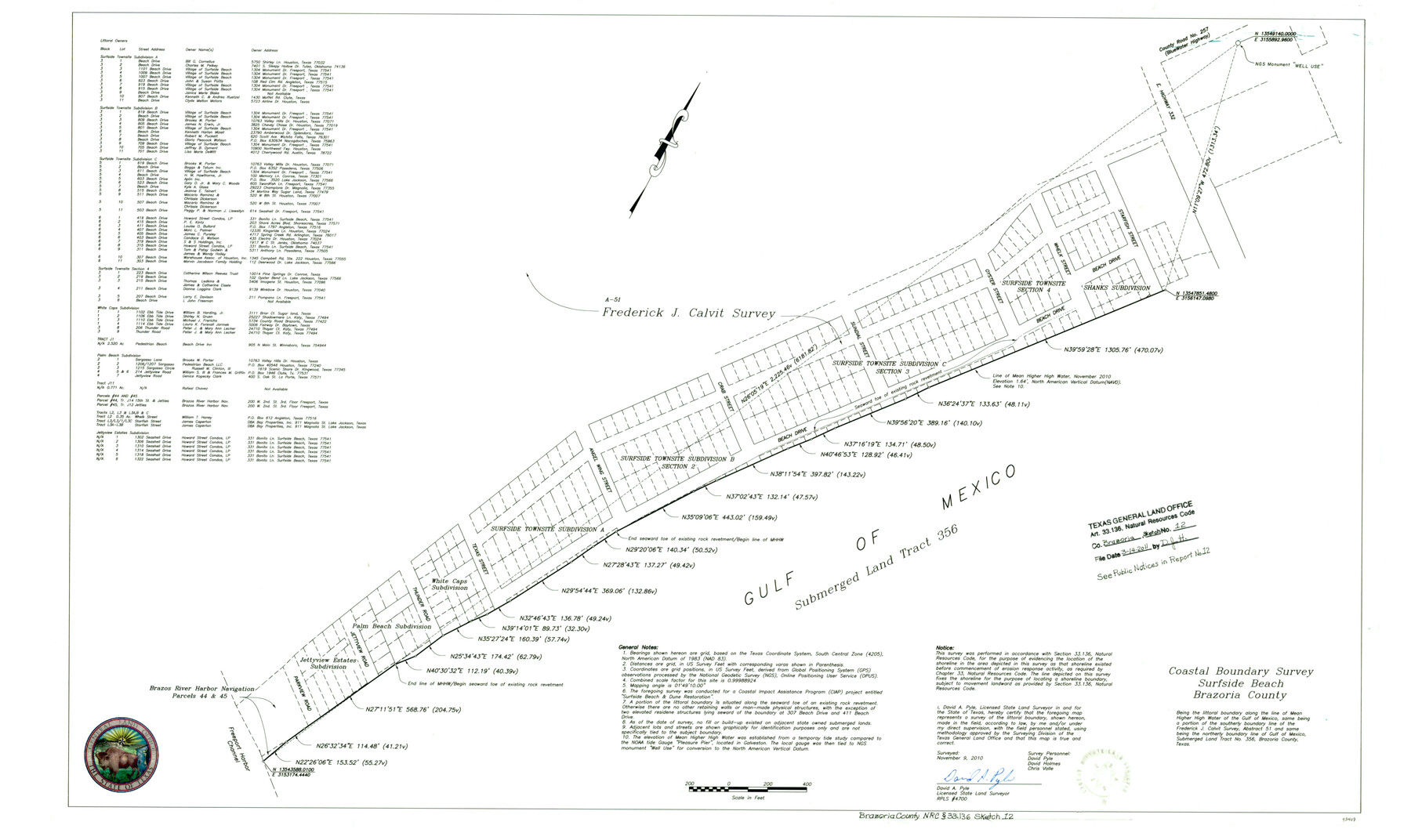
Brazoria County NRC Article 33.136 Sketch 12
Coastal Boundary Survey, Surfside Beach
-
Map/Doc
93407
-
Collection
General Map Collection
-
Object Dates
2010/11/9 (Creation Date)
2012/12/6 (File Date)
-
People and Organizations
David A. Pyle (Surveyor/Engineer)
-
Counties
Brazoria
-
Subjects
Surveying CBS
-
Height x Width
21.0 x 34.0 inches
53.3 x 86.4 cm
-
Medium
multi-page, multi-format
-
Comments
Surfside Beach and Dune Restoration Project, Project No: CEPRA 1511
Part of: General Map Collection
Reagan County Sketch File RB

Print $8.00
- Digital $50.00
Reagan County Sketch File RB
Size 11.3 x 9.0 inches
Map/Doc 34996
Kimble County Working Sketch 94

Print $20.00
- Digital $50.00
Kimble County Working Sketch 94
1993
Size 28.3 x 33.7 inches
Map/Doc 70162
Pecos County Rolled Sketch 108

Print $20.00
- Digital $50.00
Pecos County Rolled Sketch 108
1940
Size 39.7 x 30.7 inches
Map/Doc 7254

The Range and Ranch Cattle Area of the United States

Print $20.00
- Digital $50.00
The Range and Ranch Cattle Area of the United States
1884
Size 26.4 x 27.2 inches
Map/Doc 94077
Flight Mission No. DAG-21K, Frame 40, Matagorda County

Print $20.00
- Digital $50.00
Flight Mission No. DAG-21K, Frame 40, Matagorda County
1952
Size 18.6 x 19.3 inches
Map/Doc 86407
Southern Part of Laguna Madre

Print $20.00
- Digital $50.00
Southern Part of Laguna Madre
1969
Size 44.4 x 35.4 inches
Map/Doc 73541
[Surveys in Austin's Colony at Carancahua Bay]
![172, [Surveys in Austin's Colony at Carancahua Bay], General Map Collection](https://historictexasmaps.com/wmedia_w700/maps/172.tif.jpg)
Print $20.00
- Digital $50.00
[Surveys in Austin's Colony at Carancahua Bay]
Size 22.5 x 17.4 inches
Map/Doc 172
Midland County Boundary File 4b

Print $18.00
- Digital $50.00
Midland County Boundary File 4b
Size 13.6 x 9.0 inches
Map/Doc 57186
Hall County Rolled Sketch 8

Print $20.00
- Digital $50.00
Hall County Rolled Sketch 8
1942
Size 24.7 x 41.6 inches
Map/Doc 6052
Webb County Rolled Sketch 58

Print $40.00
- Digital $50.00
Webb County Rolled Sketch 58
1946
Size 36.7 x 53.4 inches
Map/Doc 10127
Edwards County Working Sketch 109

Print $40.00
- Digital $50.00
Edwards County Working Sketch 109
1972
Size 51.8 x 37.6 inches
Map/Doc 68985
You may also like
Polk County Sketch File 30

Print $18.00
- Digital $50.00
Polk County Sketch File 30
1934
Size 14.1 x 8.5 inches
Map/Doc 34206
The Republic County of Goliad. Boundaries Defined, December 2, 1841

Print $20.00
The Republic County of Goliad. Boundaries Defined, December 2, 1841
2020
Size 17.5 x 21.7 inches
Map/Doc 96151
Presidio County Rolled Sketch S1

Print $20.00
- Digital $50.00
Presidio County Rolled Sketch S1
Size 13.3 x 18.8 inches
Map/Doc 7414
Potter County Boundary File 3

Print $10.00
- Digital $50.00
Potter County Boundary File 3
Size 5.8 x 8.9 inches
Map/Doc 57974
Lee County Working Sketch 21

Print $40.00
- Digital $50.00
Lee County Working Sketch 21
2009
Size 48.7 x 36.6 inches
Map/Doc 89258
Shelby County

Print $20.00
- Digital $50.00
Shelby County
1945
Size 42.7 x 46.9 inches
Map/Doc 95639
Polk County Rolled Sketch 31

Print $20.00
- Digital $50.00
Polk County Rolled Sketch 31
Size 24.5 x 21.1 inches
Map/Doc 7317
Winkler County Working Sketch 7

Print $20.00
- Digital $50.00
Winkler County Working Sketch 7
1958
Size 45.4 x 30.2 inches
Map/Doc 72601
Bee County Working Sketch Graphic Index

Print $20.00
- Digital $50.00
Bee County Working Sketch Graphic Index
1950
Size 41.6 x 45.4 inches
Map/Doc 76464

Chambers County Sketch File 57

Print $13.00
- Digital $50.00
Chambers County Sketch File 57
1935
Size 14.7 x 8.9 inches
Map/Doc 18102
Galveston County NRC Article 33.136 Sketch 81

Print $202.00
- Digital $50.00
Galveston County NRC Article 33.136 Sketch 81
2015
Size 34.0 x 22.0 inches
Map/Doc 94976