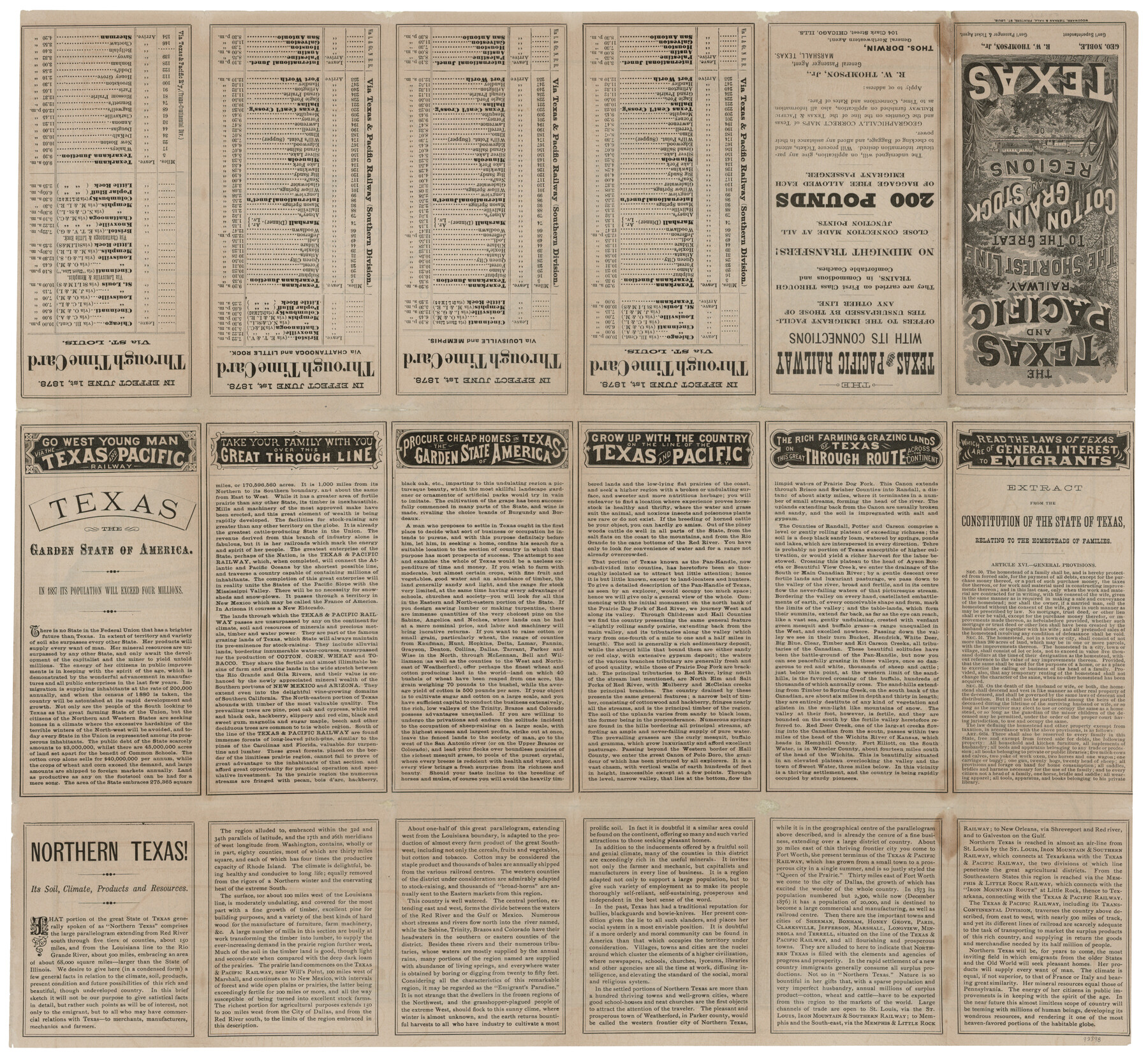
A Geographically Correct Map of the State of Texas
[verso]
-
Map/Doc
93398
-
Collection
General Map Collection
-
Object Dates
1876 (Creation Date)
-
People and Organizations
Texas and Pacific Railway Company (Publisher)
Woodward, Tiernan and Hale (Printer)
-
Subjects
State of Texas
-
Height x Width
20.0 x 21.5 inches
50.8 x 54.6 cm
-
Medium
paper, etching/engraving/lithograph
-
Comments
See 93397 for map on reverse.
Related maps
A Geographically Correct Map of the State of Texas

Print $20.00
- Digital $50.00
A Geographically Correct Map of the State of Texas
1876
Size 20.0 x 21.5 inches
Map/Doc 93397
Part of: General Map Collection
Hudspeth County Sketch File 45

Print $38.00
- Digital $50.00
Hudspeth County Sketch File 45
1982
Size 11.2 x 8.8 inches
Map/Doc 27030
[Copied from a chart of Galveston Bar and Harbor]
![72760, [Copied from a chart of Galveston Bar and Harbor], General Map Collection](https://historictexasmaps.com/wmedia_w700/maps/72760.tif.jpg)
Print $20.00
- Digital $50.00
[Copied from a chart of Galveston Bar and Harbor]
1846
Size 18.3 x 25.3 inches
Map/Doc 72760
Pecos County Sketch File 27

Print $20.00
- Digital $50.00
Pecos County Sketch File 27
1900
Size 18.1 x 14.5 inches
Map/Doc 12165
La Salle County Sketch File 29a

Print $22.00
- Digital $50.00
La Salle County Sketch File 29a
1886
Size 8.9 x 12.5 inches
Map/Doc 29563
Zavala County Sketch File 34

Print $4.00
- Digital $50.00
Zavala County Sketch File 34
1887
Size 13.0 x 8.5 inches
Map/Doc 41395
Lampasas County Sketch File 9a

Print $4.00
- Digital $50.00
Lampasas County Sketch File 9a
1872
Size 12.8 x 8.0 inches
Map/Doc 29410
Morris County Rolled Sketch 2A

Print $20.00
- Digital $50.00
Morris County Rolled Sketch 2A
Size 24.3 x 19.2 inches
Map/Doc 10284
Galveston County Rolled Sketch 45A

Print $20.00
- Digital $50.00
Galveston County Rolled Sketch 45A
1995
Size 19.6 x 29.9 inches
Map/Doc 5979
Bosque County Sketch File 18

Print $4.00
- Digital $50.00
Bosque County Sketch File 18
1863
Size 13.5 x 8.4 inches
Map/Doc 14792
Real County Rolled Sketch 1

Print $20.00
- Digital $50.00
Real County Rolled Sketch 1
1941
Size 20.6 x 28.9 inches
Map/Doc 7452
Winkler County Sketch File 15

Print $10.00
- Digital $50.00
Winkler County Sketch File 15
1944
Size 14.3 x 8.6 inches
Map/Doc 40488
Liberty County Working Sketch 68

Print $4.00
- Digital $50.00
Liberty County Working Sketch 68
1972
Size 27.4 x 24.6 inches
Map/Doc 70528
You may also like
Clay County Boundary File 17a

Print $40.00
- Digital $50.00
Clay County Boundary File 17a
Size 47.0 x 22.0 inches
Map/Doc 51435
Rand McNally Standard Map of Texas

Rand McNally Standard Map of Texas
1930
Size 34.6 x 28.0 inches
Map/Doc 2147
Flight Mission No. DCL-6C, Frame 65, Kenedy County

Print $20.00
- Digital $50.00
Flight Mission No. DCL-6C, Frame 65, Kenedy County
1943
Size 18.5 x 22.3 inches
Map/Doc 85907
Calhoun County Sketch File 5

Print $2.00
- Digital $50.00
Calhoun County Sketch File 5
Size 11.4 x 8.9 inches
Map/Doc 35907
Live Oak County Rolled Sketch 6

Print $20.00
- Digital $50.00
Live Oak County Rolled Sketch 6
1947
Size 43.6 x 25.9 inches
Map/Doc 6634
Lamar County Sketch File 14

Print $4.00
- Digital $50.00
Lamar County Sketch File 14
1873
Size 12.7 x 8.1 inches
Map/Doc 29308
General Highway Map, Fayette County, Texas

Print $20.00
General Highway Map, Fayette County, Texas
1940
Size 18.5 x 25.0 inches
Map/Doc 79089
Anderson County Working Sketch 44

Print $20.00
- Digital $50.00
Anderson County Working Sketch 44
1991
Size 27.7 x 32.3 inches
Map/Doc 67044
Sketch F No. 2 Showing the progress of the Survey of Cedar Keys, Bahia Honda, Key Biscayne, Key West & Dry Tortugas In Section No. VI

Print $20.00
- Digital $50.00
Sketch F No. 2 Showing the progress of the Survey of Cedar Keys, Bahia Honda, Key Biscayne, Key West & Dry Tortugas In Section No. VI
1849
Size 10.8 x 18.3 inches
Map/Doc 97217
Flight Mission No. CRC-3R, Frame 20, Chambers County

Print $20.00
- Digital $50.00
Flight Mission No. CRC-3R, Frame 20, Chambers County
1956
Size 18.6 x 22.2 inches
Map/Doc 84794
Hardin County Working Sketch 12

Print $3.00
- Digital $50.00
Hardin County Working Sketch 12
1934
Size 16.8 x 11.9 inches
Map/Doc 63410
Coke County Sketch File 2

Print $22.00
- Digital $50.00
Coke County Sketch File 2
Size 9.1 x 7.8 inches
Map/Doc 18565