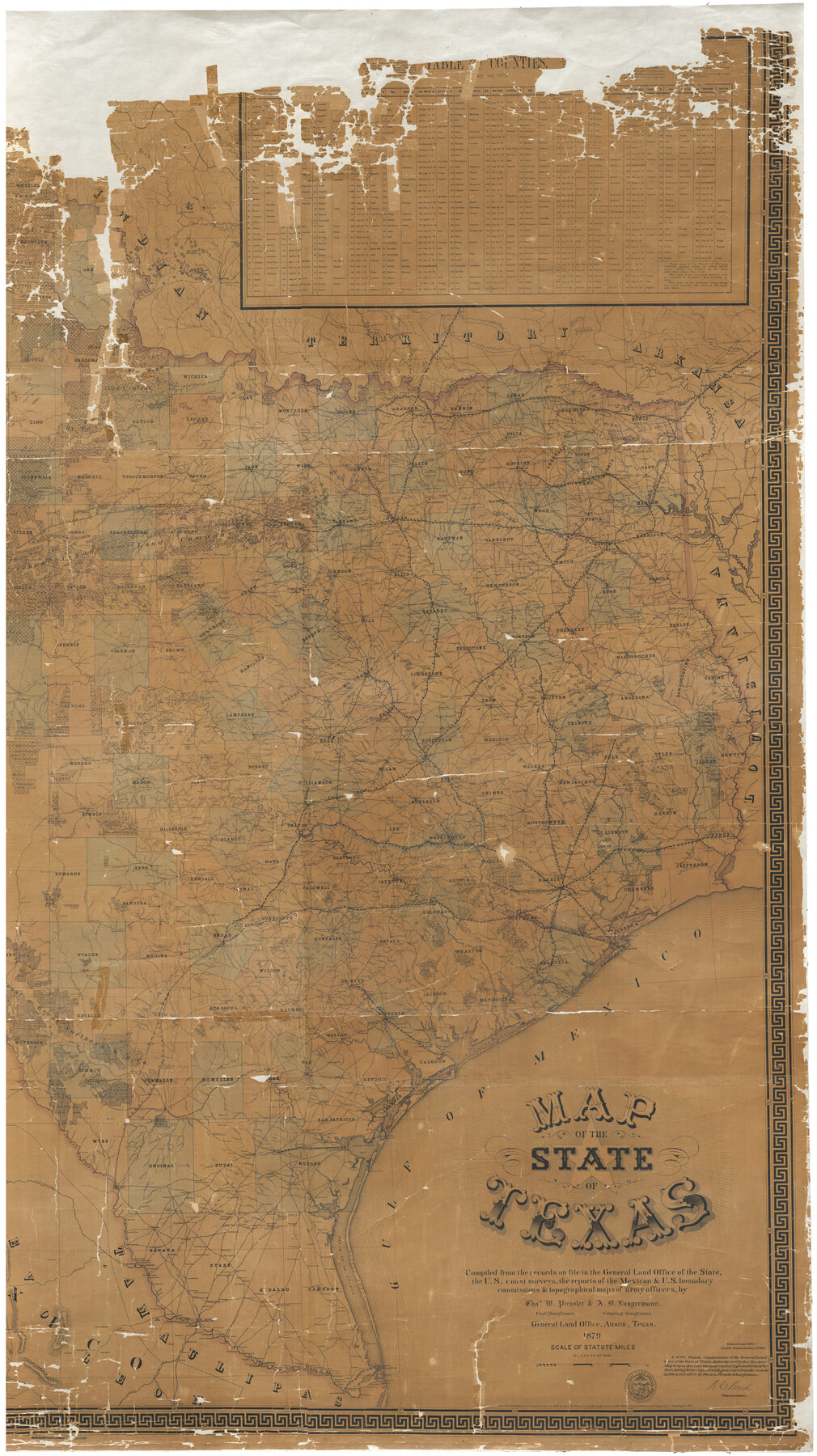
Map of the State of Texas
-
Map/Doc
93383
-
Collection
General Map Collection
-
Object Dates
1879 (Creation Date)
-
People and Organizations
Texas General Land Office (Publisher)
Am. Photo-Lithographical Co. (Printer)
Chas. W. Pressler (Draftsman)
W.C. Walsh (GLO Commissioner)
A.B. Langermann (Compiler)
-
Subjects
State of Texas
-
Height x Width
102.7 x 57.6 inches
260.9 x 146.3 cm
-
Comments
Note on map: "Compiled from the records on file in the General Land Office of the state, the U. S. coast surveys, the reports of the Mexican and U. S. boundary commissions, and topographical maps of army officers".
Conservation funded in 2001.
East half of map. See map 93382 for west half and map 16973 for a digital composite of the full map.
Related maps
Map of the State of Texas

Print $40.00
- Digital $50.00
Map of the State of Texas
1879
Size 102.7 x 106.6 inches
Map/Doc 16973
Map of the State of Texas

Print $40.00
- Digital $50.00
Map of the State of Texas
1879
Size 102.7 x 56.3 inches
Map/Doc 93382
Part of: General Map Collection
Brewster County Rolled Sketch 60

Print $40.00
- Digital $50.00
Brewster County Rolled Sketch 60
1942
Size 42.9 x 48.0 inches
Map/Doc 16960
Morris County Rolled Sketch 2A

Print $20.00
- Digital $50.00
Morris County Rolled Sketch 2A
Size 24.4 x 19.4 inches
Map/Doc 10245
Callahan County Rolled Sketch 2

Print $20.00
- Digital $50.00
Callahan County Rolled Sketch 2
1947
Size 19.1 x 23.0 inches
Map/Doc 5380
Baylor County Boundary File 11

Print $26.00
- Digital $50.00
Baylor County Boundary File 11
Size 11.1 x 8.7 inches
Map/Doc 50419
Loving County Working Sketch 9

Print $20.00
- Digital $50.00
Loving County Working Sketch 9
1952
Size 24.8 x 45.8 inches
Map/Doc 70641
Caldwell County Rolled Sketch 1

Print $20.00
- Digital $50.00
Caldwell County Rolled Sketch 1
1953
Size 20.2 x 30.4 inches
Map/Doc 10673
Jefferson County Rolled Sketch 61D

Print $20.00
- Digital $50.00
Jefferson County Rolled Sketch 61D
Size 27.2 x 40.5 inches
Map/Doc 6413
Scurry County Rolled Sketch 14

Print $20.00
- Digital $50.00
Scurry County Rolled Sketch 14
2016
Size 23.4 x 41.4 inches
Map/Doc 95404
Diefert Situs Orbis Hydrographorum ab eo quem Ptolomeus Posuit

Print $20.00
- Digital $50.00
Diefert Situs Orbis Hydrographorum ab eo quem Ptolomeus Posuit
1522
Size 13.9 x 19.1 inches
Map/Doc 96578
Concho County Working Sketch 1

Print $20.00
- Digital $50.00
Concho County Working Sketch 1
Size 29.3 x 36.8 inches
Map/Doc 68183
Henderson County Boundary File 3a

Print $30.00
- Digital $50.00
Henderson County Boundary File 3a
Size 14.4 x 8.9 inches
Map/Doc 54685
Young County Working Sketch 18

Print $20.00
- Digital $50.00
Young County Working Sketch 18
1960
Size 23.9 x 29.2 inches
Map/Doc 62041
You may also like
San Jacinto County Rolled Sketch 12
Print $20.00
- Digital $50.00
San Jacinto County Rolled Sketch 12
1948
Size 24.2 x 32.5 inches
Map/Doc 7561
Swisher County Sketch File 5

Print $8.00
- Digital $50.00
Swisher County Sketch File 5
1876
Size 14.3 x 8.8 inches
Map/Doc 37618
Matagorda County NRC Article 33.136 Sketch 17

Print $24.00
Matagorda County NRC Article 33.136 Sketch 17
2023
Map/Doc 97274
Menard County Working Sketch 23

Print $20.00
- Digital $50.00
Menard County Working Sketch 23
1950
Size 45.1 x 41.3 inches
Map/Doc 70970
Edwards County Working Sketch 40

Print $20.00
- Digital $50.00
Edwards County Working Sketch 40
1949
Size 19.8 x 18.6 inches
Map/Doc 68916
Val Verde County Sketch File F

Print $42.00
- Digital $50.00
Val Verde County Sketch File F
1906
Size 40.1 x 16.9 inches
Map/Doc 10423
Parker County Sketch File 16

Print $22.00
- Digital $50.00
Parker County Sketch File 16
1870
Size 12.9 x 16.3 inches
Map/Doc 33550
Jefferson County NRC Article 33.136 Sketch 12

Print $22.00
- Digital $50.00
Jefferson County NRC Article 33.136 Sketch 12
2017
Size 24.0 x 36.0 inches
Map/Doc 95055
[George Gentry, Wm. Williams, and surrounding surveys]
![90973, [George Gentry, Wm. Williams, and surrounding surveys], Twichell Survey Records](https://historictexasmaps.com/wmedia_w700/maps/90973-1.tif.jpg)
Print $2.00
- Digital $50.00
[George Gentry, Wm. Williams, and surrounding surveys]
Size 8.3 x 12.6 inches
Map/Doc 90973
Amistad International Reservoir on Rio Grande Key Sheet

Print $20.00
- Digital $50.00
Amistad International Reservoir on Rio Grande Key Sheet
1960
Size 13.0 x 32.4 inches
Map/Doc 73345
[John Schrier's league]
![286, [John Schrier's league], General Map Collection](https://historictexasmaps.com/wmedia_w700/maps/286.tif.jpg)
Print $2.00
- Digital $50.00
[John Schrier's league]
1847
Size 7.2 x 8.6 inches
Map/Doc 286
Edwards County Working Sketch 57

Print $20.00
- Digital $50.00
Edwards County Working Sketch 57
1952
Size 22.7 x 32.3 inches
Map/Doc 68933