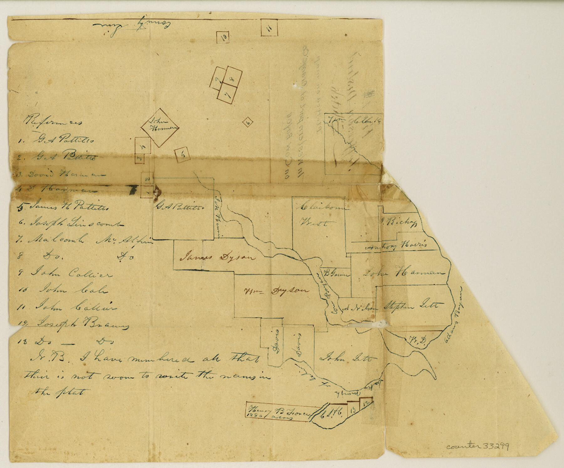
Orange County Sketch File 1
[Sketch of surveys on both sides of Cow Bayou west of Orange]
-
Map/Doc
33299
-
Collection
General Map Collection
-
Counties
Orange
-
Subjects
Surveying Sketch File
-
Height x Width
9.6 x 11.5 inches
24.4 x 29.2 cm
-
Medium
paper, manuscript
-
Features
Cow Bayou
Adams Bayou
Oak Marsh of Sabine [River]
Part of: General Map Collection
Somervell County Sketch File 2

Print $20.00
- Digital $50.00
Somervell County Sketch File 2
1847
Size 21.8 x 16.7 inches
Map/Doc 12325
Stephens County Boundary File 2

Print $34.00
- Digital $50.00
Stephens County Boundary File 2
Size 14.2 x 8.7 inches
Map/Doc 58866
Flight Mission No. CRE-2R, Frame 90, Jackson County

Print $20.00
- Digital $50.00
Flight Mission No. CRE-2R, Frame 90, Jackson County
1956
Size 16.0 x 15.8 inches
Map/Doc 85362
Refugio District

Print $20.00
- Digital $50.00
Refugio District
1855
Size 30.7 x 34.7 inches
Map/Doc 2139
Presidio County Working Sketch 53

Print $5.00
- Digital $50.00
Presidio County Working Sketch 53
1955
Size 28.6 x 18.9 inches
Map/Doc 71730
Leon County Working Sketch 26

Print $20.00
- Digital $50.00
Leon County Working Sketch 26
1969
Size 43.1 x 46.9 inches
Map/Doc 70425
Galveston Harbor and Channel, Texas Rehabilitation of South Jetty, Comparison of Shorelines and Offshore Contours 1890 to 1960

Print $20.00
- Digital $50.00
Galveston Harbor and Channel, Texas Rehabilitation of South Jetty, Comparison of Shorelines and Offshore Contours 1890 to 1960
1961
Size 31.6 x 41.8 inches
Map/Doc 61827
St. Louis Southwestern Railway of Texas

Print $20.00
- Digital $50.00
St. Louis Southwestern Railway of Texas
1906
Size 21.2 x 30.0 inches
Map/Doc 64447
Flight Mission No. CRK-5P, Frame 129, Refugio County

Print $20.00
- Digital $50.00
Flight Mission No. CRK-5P, Frame 129, Refugio County
1956
Size 18.4 x 22.3 inches
Map/Doc 86932
Dickens County Working Sketch 4

Print $20.00
- Digital $50.00
Dickens County Working Sketch 4
1914
Size 27.9 x 18.8 inches
Map/Doc 68651
Flight Mission No. CRK-8P, Frame 107, Refugio County

Print $20.00
- Digital $50.00
Flight Mission No. CRK-8P, Frame 107, Refugio County
1956
Size 18.4 x 22.0 inches
Map/Doc 86968
Die Vereinigten Staaten von Nord-America

Print $20.00
- Digital $50.00
Die Vereinigten Staaten von Nord-America
1834
Size 23.5 x 28.1 inches
Map/Doc 93694
You may also like
Franklin County Sketch File 5

Print $2.00
- Digital $50.00
Franklin County Sketch File 5
Size 8.2 x 10.7 inches
Map/Doc 23017
English Field Notes of the Spanish Archives - Books J.S.2, 3, and 4

English Field Notes of the Spanish Archives - Books J.S.2, 3, and 4
1835
Map/Doc 96550

Schleicher County Working Sketch 24

Print $20.00
- Digital $50.00
Schleicher County Working Sketch 24
1955
Size 42.6 x 43.3 inches
Map/Doc 63826
Corpus Christi Pass

Print $20.00
- Digital $50.00
Corpus Christi Pass
Size 45.7 x 41.2 inches
Map/Doc 78454
Nueces County Rolled Sketch 71

Print $247.00
Nueces County Rolled Sketch 71
1980
Size 37.9 x 24.7 inches
Map/Doc 6924
McMullen County Sketch File 20

Print $4.00
- Digital $50.00
McMullen County Sketch File 20
Size 8.1 x 10.0 inches
Map/Doc 31373
McMullen County Rolled Sketch 9

Print $20.00
- Digital $50.00
McMullen County Rolled Sketch 9
Size 34.4 x 40.9 inches
Map/Doc 6726
Lavaca County Working Sketch 11

Print $20.00
- Digital $50.00
Lavaca County Working Sketch 11
1954
Size 34.0 x 28.3 inches
Map/Doc 70364
Duval County Rolled Sketch GEB

Print $20.00
- Digital $50.00
Duval County Rolled Sketch GEB
1935
Size 26.9 x 30.4 inches
Map/Doc 5768
Hutchinson County Rolled Sketch 36

Print $20.00
- Digital $50.00
Hutchinson County Rolled Sketch 36
1888
Size 20.3 x 25.3 inches
Map/Doc 6293
Edwards County Working Sketch 68

Print $20.00
- Digital $50.00
Edwards County Working Sketch 68
1957
Size 28.7 x 26.8 inches
Map/Doc 68944