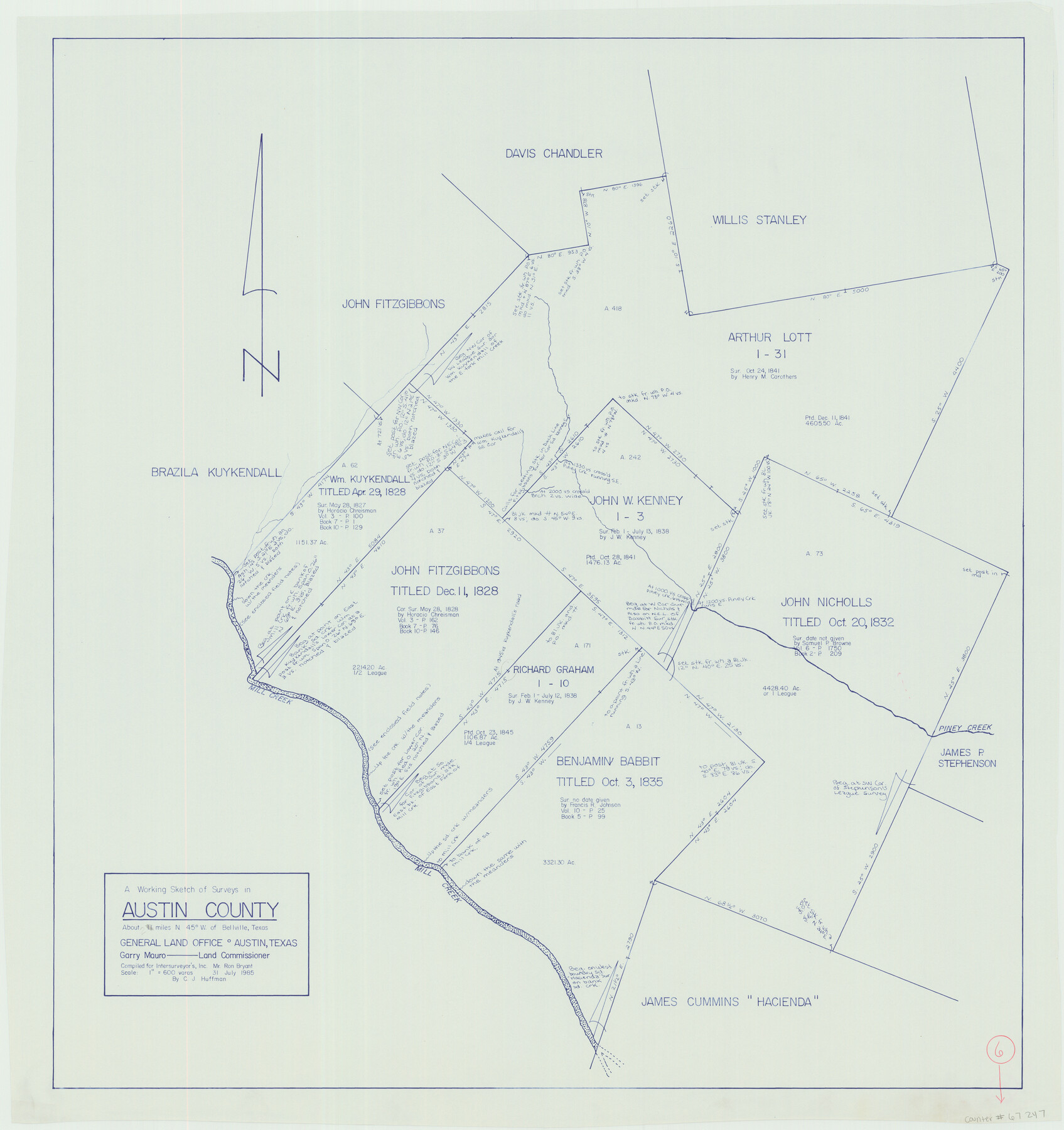
Austin County Working Sketch 6
-
Map/Doc
67247
-
Collection
General Map Collection
-
Object Dates
7/31/1985 (Creation Date)
-
People and Organizations
Garry Mauro (GLO Commissioner)
Huffman, Cynthia J. (Draftsman)
-
Counties
Austin
-
Subjects
Surveying Working Sketch
-
Height x Width
30.3 x 28.5 inches
77.0 x 72.4 cm
-
Scale
1" = 600 varas
-
Comments
Surveys located about two miles North 45 degrees West of Bellville, Texas.
Part of: General Map Collection
Brazoria County Boundary File 2

Print $140.00
- Digital $50.00
Brazoria County Boundary File 2
Size 12.8 x 9.8 inches
Map/Doc 50704
Flight Mission No. DIX-7P, Frame 88, Aransas County

Print $20.00
- Digital $50.00
Flight Mission No. DIX-7P, Frame 88, Aransas County
1956
Size 18.7 x 22.3 inches
Map/Doc 83882
Index for Texas Railroad ROW & track maps available on microfilm at THD & Archives and Records

Print $2.00
- Digital $50.00
Index for Texas Railroad ROW & track maps available on microfilm at THD & Archives and Records
1977
Size 11.1 x 8.7 inches
Map/Doc 60762
Brazoria County Sketch File 35

Print $40.00
- Digital $50.00
Brazoria County Sketch File 35
Size 15.5 x 18.4 inches
Map/Doc 10958
Atlas Pintoresco e Historico de los Estados Unidos Mexicanos

Atlas Pintoresco e Historico de los Estados Unidos Mexicanos
Map/Doc 96796
Dallas County

Print $20.00
- Digital $50.00
Dallas County
1942
Size 44.5 x 36.9 inches
Map/Doc 95475
Marion County Working Sketch 11

Print $20.00
- Digital $50.00
Marion County Working Sketch 11
1952
Size 23.8 x 28.7 inches
Map/Doc 70786
Jackson County Sketch File 5

Print $4.00
- Digital $50.00
Jackson County Sketch File 5
1876
Size 12.7 x 8.2 inches
Map/Doc 27628
Culberson County Sketch File 3b

Print $20.00
- Digital $50.00
Culberson County Sketch File 3b
1880
Size 20.3 x 28.0 inches
Map/Doc 11262
San Augustine County

Print $20.00
- Digital $50.00
San Augustine County
1895
Size 23.7 x 17.2 inches
Map/Doc 4015
Brewster County Rolled Sketch 114

Print $20.00
- Digital $50.00
Brewster County Rolled Sketch 114
1964
Size 11.4 x 18.4 inches
Map/Doc 5277
Matagorda Bay Including Lavaca and Tres Palacios Bays

Print $20.00
- Digital $50.00
Matagorda Bay Including Lavaca and Tres Palacios Bays
1992
Size 37.0 x 47.8 inches
Map/Doc 73366
You may also like
[Index map of T. & P. Ry. Company’s 80-mile Trans-Pecos Reserve’s perpetuated corners - South Part]
![69766, [Index map of T. & P. Ry. Company’s 80-mile Trans-Pecos Reserve’s perpetuated corners - South Part], General Map Collection](https://historictexasmaps.com/wmedia_w700/maps/69766.tif.jpg)
Print $40.00
- Digital $50.00
[Index map of T. & P. Ry. Company’s 80-mile Trans-Pecos Reserve’s perpetuated corners - South Part]
Size 23.1 x 90.1 inches
Map/Doc 69766
Map of the Country Upon the Brazos and Big Wichita Rivers Embracing the Lands appropriated by the State of Texas for the Use of the Indians

Print $20.00
Map of the Country Upon the Brazos and Big Wichita Rivers Embracing the Lands appropriated by the State of Texas for the Use of the Indians
1854
Size 28.8 x 32.3 inches
Map/Doc 76284
Loving County Working Sketch 7

Print $20.00
- Digital $50.00
Loving County Working Sketch 7
1949
Size 23.4 x 26.3 inches
Map/Doc 70639
Harris County State Real Property Sketch 6

Print $20.00
- Digital $50.00
Harris County State Real Property Sketch 6
Size 23.6 x 35.9 inches
Map/Doc 96641
Galveston County NRC Article 33.136 Sketch 53

Print $24.00
- Digital $50.00
Galveston County NRC Article 33.136 Sketch 53
2009
Size 22.3 x 34.0 inches
Map/Doc 94609
Atascosa County Sketch File 12

Print $4.00
- Digital $50.00
Atascosa County Sketch File 12
1862
Size 14.4 x 8.3 inches
Map/Doc 13769
Colorado County Working Sketch 6

Print $20.00
- Digital $50.00
Colorado County Working Sketch 6
1921
Size 15.4 x 14.3 inches
Map/Doc 68106
[Blocks 3, Q, and Vicinity]
![91276, [Blocks 3, Q, and Vicinity], Twichell Survey Records](https://historictexasmaps.com/wmedia_w700/maps/91276.tif.jpg)
Print $20.00
- Digital $50.00
[Blocks 3, Q, and Vicinity]
Size 19.1 x 9.2 inches
Map/Doc 91276

Sylvan Sander's Map of Lubbock, Hockley, and Cochran Counties, Texas

Print $20.00
- Digital $50.00
Sylvan Sander's Map of Lubbock, Hockley, and Cochran Counties, Texas
1925
Size 43.6 x 21.8 inches
Map/Doc 92611
Trinity County Sketch File 30

Print $8.00
- Digital $50.00
Trinity County Sketch File 30
1891
Size 14.2 x 8.9 inches
Map/Doc 38566
Lynn County Sketch File A3

Print $4.00
- Digital $50.00
Lynn County Sketch File A3
1904
Size 12.7 x 8.0 inches
Map/Doc 30473