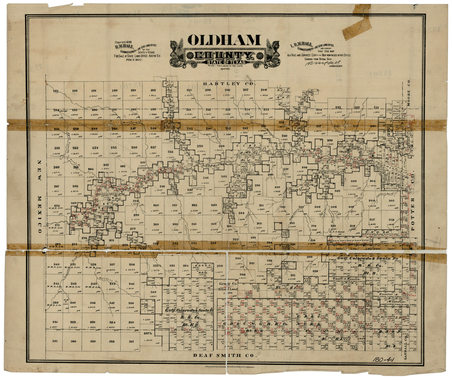
Oldham County
180-41
-
Map/Doc
93018
-
Collection
Twichell Survey Records
-
Object Dates
4/1888 (Creation Date)
-
Counties
Oldham
-
Subjects
County
-
Height x Width
19.6 x 16.5 inches
49.8 x 41.9 cm
-
Comments
Gast lithograph of GLO County Map
Part of: Twichell Survey Records
University of Texas System University Lands

Print $20.00
- Digital $50.00
University of Texas System University Lands
Size 17.9 x 23.3 inches
Map/Doc 93244
Map of C. C. Slaughter Cattle Co.'s Ranch, Cochran-Hockley Counties, Texas

Print $20.00
- Digital $50.00
Map of C. C. Slaughter Cattle Co.'s Ranch, Cochran-Hockley Counties, Texas
Size 27.4 x 20.3 inches
Map/Doc 90439
[H. & T. C. 49, Part of G. C. & S. 35, Capitol Leagues 206, 207, 214, 215]
![90688, [H. & T. C. 49, Part of G. C. & S. 35, Capitol Leagues 206, 207, 214, 215], Twichell Survey Records](https://historictexasmaps.com/wmedia_w700/maps/90688-1.tif.jpg)
Print $20.00
- Digital $50.00
[H. & T. C. 49, Part of G. C. & S. 35, Capitol Leagues 206, 207, 214, 215]
1903
Size 13.1 x 13.2 inches
Map/Doc 90688
[Hockley, Lubbock, Terry and Lynn Corner]
![92889, [Hockley, Lubbock, Terry and Lynn Corner], Twichell Survey Records](https://historictexasmaps.com/wmedia_w700/maps/92889-1.tif.jpg)
Print $20.00
- Digital $50.00
[Hockley, Lubbock, Terry and Lynn Corner]
Size 17.6 x 15.6 inches
Map/Doc 92889
[H. & O. B. Blocks 1, B9, 24, J]
![90345, [H. & O. B. Blocks 1, B9, 24, J], Twichell Survey Records](https://historictexasmaps.com/wmedia_w700/maps/90345-1.tif.jpg)
Print $20.00
- Digital $50.00
[H. & O. B. Blocks 1, B9, 24, J]
Size 25.2 x 23.6 inches
Map/Doc 90345
C.C. Slaughter's Running Water Ranch situated in Hale and Lamb Counties

Print $40.00
- Digital $50.00
C.C. Slaughter's Running Water Ranch situated in Hale and Lamb Counties
Size 38.1 x 55.5 inches
Map/Doc 89924
Map of Blockline between 33 and 34, Township 5 North

Print $20.00
- Digital $50.00
Map of Blockline between 33 and 34, Township 5 North
1919
Size 20.5 x 34.5 inches
Map/Doc 92565
Roach Estate Ranch, Gaines County, Texas

Print $20.00
- Digital $50.00
Roach Estate Ranch, Gaines County, Texas
Size 18.0 x 34.6 inches
Map/Doc 92681
[Sketch showing Jeff Davis County, Blocks 1, 2, 3, 4, 360, 363 and JG1]
![91776, [Sketch showing Jeff Davis County, Blocks 1, 2, 3, 4, 360, 363 and JG1], Twichell Survey Records](https://historictexasmaps.com/wmedia_w700/maps/91776-1.tif.jpg)
Print $20.00
- Digital $50.00
[Sketch showing Jeff Davis County, Blocks 1, 2, 3, 4, 360, 363 and JG1]
Size 20.5 x 13.7 inches
Map/Doc 91776
[Part of H. & G. N. Blocks 2 and D-13]
![90490, [Part of H. & G. N. Blocks 2 and D-13], Twichell Survey Records](https://historictexasmaps.com/wmedia_w700/maps/90490-1.tif.jpg)
Print $20.00
- Digital $50.00
[Part of H. & G. N. Blocks 2 and D-13]
1907
Size 14.1 x 17.7 inches
Map/Doc 90490
[H. & T. C. RR. Company, Block 47, Sections 47- 52]
![91411, [H. & T. C. RR. Company, Block 47, Sections 47- 52], Twichell Survey Records](https://historictexasmaps.com/wmedia_w700/maps/91411-1.tif.jpg)
Print $2.00
- Digital $50.00
[H. & T. C. RR. Company, Block 47, Sections 47- 52]
Size 8.6 x 11.1 inches
Map/Doc 91411
[Block H, Block 24]
![92598, [Block H, Block 24], Twichell Survey Records](https://historictexasmaps.com/wmedia_w700/maps/92598-1.tif.jpg)
Print $20.00
- Digital $50.00
[Block H, Block 24]
Size 30.2 x 17.0 inches
Map/Doc 92598
You may also like
Liberty County Rolled Sketch JP2

Print $40.00
- Digital $50.00
Liberty County Rolled Sketch JP2
1935
Size 52.2 x 12.7 inches
Map/Doc 81403
Midland County Working Sketch 29

Print $40.00
- Digital $50.00
Midland County Working Sketch 29
1971
Size 49.4 x 35.6 inches
Map/Doc 71010
Sterling County Working Sketch 6

Print $40.00
- Digital $50.00
Sterling County Working Sketch 6
1955
Size 38.1 x 121.6 inches
Map/Doc 63988
Map of Coryell Co.

Print $40.00
- Digital $50.00
Map of Coryell Co.
1896
Size 48.0 x 46.2 inches
Map/Doc 66786
Rusk County Sketch File 12

Print $6.00
- Digital $50.00
Rusk County Sketch File 12
1845
Size 8.4 x 7.9 inches
Map/Doc 35511
Hidalgo County Sketch File 2

Print $14.00
- Digital $50.00
Hidalgo County Sketch File 2
1877
Size 10.1 x 8.1 inches
Map/Doc 26394
List of County School Lands

Print $20.00
- Digital $50.00
List of County School Lands
Size 17.7 x 23.2 inches
Map/Doc 65797
Connected Map of Austin's Colony

Print $40.00
- Digital $50.00
Connected Map of Austin's Colony
1837
Size 90.8 x 85.6 inches
Map/Doc 1944
Crockett County Working Sketch 63

Print $20.00
- Digital $50.00
Crockett County Working Sketch 63
1957
Size 21.3 x 36.1 inches
Map/Doc 68396
Coast Chart No. 212 - From Latitude 26° 33' to the Rio Grande Texas

Print $20.00
- Digital $50.00
Coast Chart No. 212 - From Latitude 26° 33' to the Rio Grande Texas
1886
Size 18.3 x 24.1 inches
Map/Doc 72835
General Highway Map. Detail of Cities and Towns in Tarrant County, Texas. City Map, Fort Worth and vicinity, Tarrant County, Texas

Print $20.00
General Highway Map. Detail of Cities and Towns in Tarrant County, Texas. City Map, Fort Worth and vicinity, Tarrant County, Texas
1961
Size 18.4 x 25.1 inches
Map/Doc 79666
Wharton County Working Sketch 11

Print $20.00
- Digital $50.00
Wharton County Working Sketch 11
1976
Size 42.2 x 40.8 inches
Map/Doc 72475