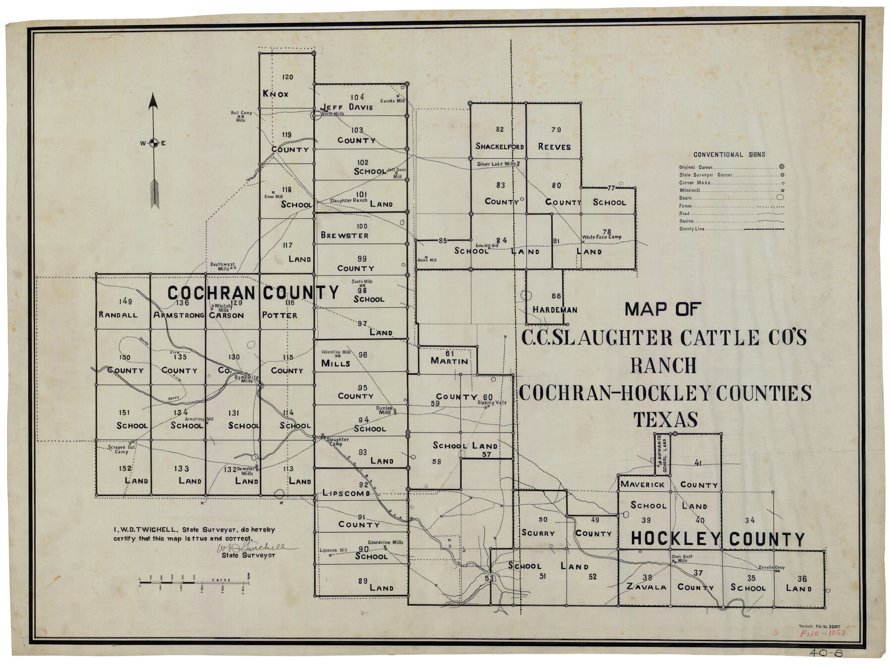
Map of C. C. Slaughter Cattle Co.'s Ranch, Cochran-Hockley Counties, Texas
40-8
-
Map/Doc
90439
-
Collection
Twichell Survey Records
-
People and Organizations
W.D. Twichell (Surveyor/Engineer)
-
Counties
Cochran Hockley
-
Height x Width
27.4 x 20.3 inches
69.6 x 51.6 cm
Part of: Twichell Survey Records
Property Line Map, Low Rent Housing Project Texas 18-1, Housing Authority of the City of Lubbock

Print $20.00
- Digital $50.00
Property Line Map, Low Rent Housing Project Texas 18-1, Housing Authority of the City of Lubbock
1941
Size 42.2 x 27.9 inches
Map/Doc 92753
[E. L. & R. R. Block 10]
![91352, [E. L. & R. R. Block 10], Twichell Survey Records](https://historictexasmaps.com/wmedia_w700/maps/91352-1.tif.jpg)
Print $20.00
- Digital $50.00
[E. L. & R. R. Block 10]
Size 25.6 x 15.8 inches
Map/Doc 91352
Jones Subdivision of Sections 28 and 32, Block "A' and Section 2, Block "D3"

Print $2.00
- Digital $50.00
Jones Subdivision of Sections 28 and 32, Block "A' and Section 2, Block "D3"
1928
Size 8.7 x 8.7 inches
Map/Doc 92708
Parkland Place

Print $20.00
- Digital $50.00
Parkland Place
1928
Size 15.9 x 13.0 inches
Map/Doc 92278

The Espuela Land and Cattle Co. L'd. West Pastures of the Spur Ranch

Print $20.00
- Digital $50.00
The Espuela Land and Cattle Co. L'd. West Pastures of the Spur Ranch
1904
Size 41.2 x 44.3 inches
Map/Doc 89947
[Sections 47-76 and part of Block 3]
![91807, [Sections 47-76 and part of Block 3], Twichell Survey Records](https://historictexasmaps.com/wmedia_w700/maps/91807-1.tif.jpg)
Print $20.00
- Digital $50.00
[Sections 47-76 and part of Block 3]
Size 34.1 x 31.7 inches
Map/Doc 91807
Rattlesnake Pasture in Howard and Borden Counties

Print $20.00
- Digital $50.00
Rattlesnake Pasture in Howard and Borden Counties
1908
Size 34.2 x 29.9 inches
Map/Doc 91204
Farmer Subdivision of Wm. Baker Survey

Print $20.00
- Digital $50.00
Farmer Subdivision of Wm. Baker Survey
Size 16.1 x 15.5 inches
Map/Doc 90122
[East Portion of Lea County] / [Central part of San Miguel County, New Mexico]
![92035, [East Portion of Lea County] / [Central part of San Miguel County, New Mexico], Twichell Survey Records](https://historictexasmaps.com/wmedia_w700/maps/92035-1.tif.jpg)
Print $20.00
- Digital $50.00
[East Portion of Lea County] / [Central part of San Miguel County, New Mexico]
Size 24.9 x 28.9 inches
Map/Doc 92035
[Block V and surrounding surveys]
![90293, [Block V and surrounding surveys], Twichell Survey Records](https://historictexasmaps.com/wmedia_w700/maps/90293-1.tif.jpg)
Print $20.00
- Digital $50.00
[Block V and surrounding surveys]
Size 12.0 x 12.6 inches
Map/Doc 90293
Sketch Showing all that Portion of Block 24 North of Santa Fe R. R. Right-of-Way in Original Town of Lubbock

Print $20.00
- Digital $50.00
Sketch Showing all that Portion of Block 24 North of Santa Fe R. R. Right-of-Way in Original Town of Lubbock
1925
Size 27.5 x 35.6 inches
Map/Doc 92810
You may also like

Harris County Working Sketch 24

Print $20.00
- Digital $50.00
Harris County Working Sketch 24
1928
Size 29.3 x 15.9 inches
Map/Doc 65916
Anderson County Sketch File 24

Print $60.00
- Digital $50.00
Anderson County Sketch File 24
1942
Size 13.2 x 18.2 inches
Map/Doc 10803
Brewster County Sketch File N-13

Print $8.00
- Digital $50.00
Brewster County Sketch File N-13
1935
Size 14.3 x 8.7 inches
Map/Doc 15625
Clay County Working Sketch 11

Print $20.00
- Digital $50.00
Clay County Working Sketch 11
1941
Size 27.7 x 27.1 inches
Map/Doc 68034
Borden County Boundary File 1

Print $60.00
- Digital $50.00
Borden County Boundary File 1
Size 13.7 x 8.7 inches
Map/Doc 50605
Marion County Working Sketch 22

Print $20.00
- Digital $50.00
Marion County Working Sketch 22
1960
Size 34.3 x 27.5 inches
Map/Doc 70798
Leon County Working Sketch 56

Print $20.00
- Digital $50.00
Leon County Working Sketch 56
1991
Size 32.7 x 26.4 inches
Map/Doc 70456
Brooks County Rolled Sketch 18

Print $20.00
- Digital $50.00
Brooks County Rolled Sketch 18
Size 11.3 x 16.1 inches
Map/Doc 61786
General Highway Map. Detail of Cities and Towns in Gray County, Texas. [Pampa and vicinity]
![79484, General Highway Map. Detail of Cities and Towns in Gray County, Texas. [Pampa and vicinity], Texas State Library and Archives](https://historictexasmaps.com/wmedia_w700/maps/79484.tif.jpg)
Print $20.00
General Highway Map. Detail of Cities and Towns in Gray County, Texas. [Pampa and vicinity]
1961
Size 24.7 x 18.1 inches
Map/Doc 79484
Matagorda County NRC Article 33.136 Sketch 24

Print $78.00
Matagorda County NRC Article 33.136 Sketch 24
2025
Map/Doc 97509
[Sketch of Elizabeth Stanley and Wm. Rivers surveys]
![91982, [Sketch of Elizabeth Stanley and Wm. Rivers surveys], Twichell Survey Records](https://historictexasmaps.com/wmedia_w700/maps/91982-1.tif.jpg)
Print $20.00
- Digital $50.00
[Sketch of Elizabeth Stanley and Wm. Rivers surveys]
Size 23.3 x 10.3 inches
Map/Doc 91982