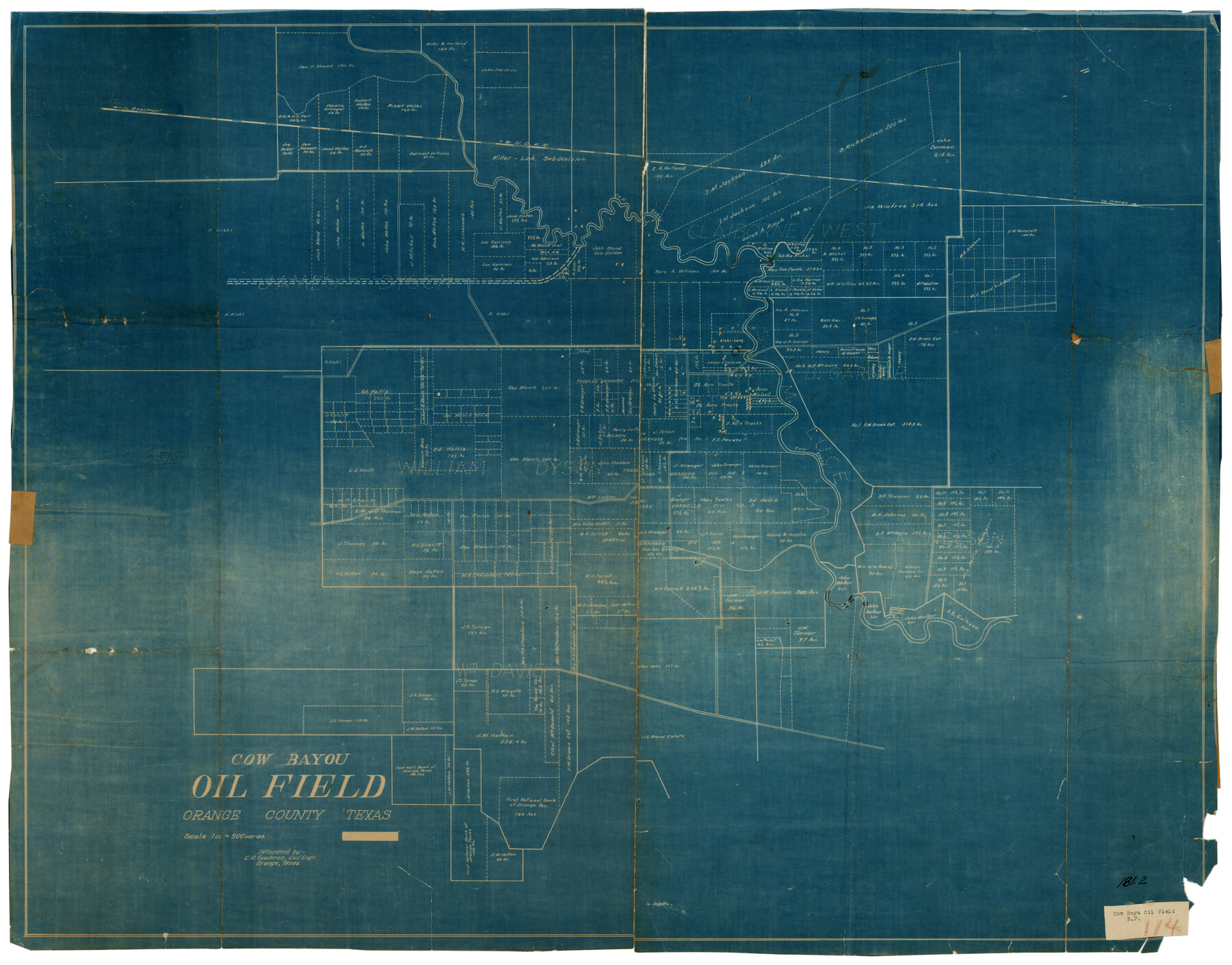
Cow Bayou Oil Field, Orange County, Texas
181-2
-
Map/Doc
93016
-
Collection
Twichell Survey Records
-
People and Organizations
C.R. Goodman (Surveyor/Engineer)
-
Counties
Orange
-
Height x Width
24.0 x 18.8 inches
61.0 x 47.8 cm
Part of: Twichell Survey Records
Richland Hills Addition to Muleshoe, Bailey County, Texas

Print $20.00
- Digital $50.00
Richland Hills Addition to Muleshoe, Bailey County, Texas
1957
Size 22.9 x 31.8 inches
Map/Doc 92532
Map of the Northeast Part of the Pitchfork Ranch

Print $20.00
- Digital $50.00
Map of the Northeast Part of the Pitchfork Ranch
1916
Size 23.4 x 23.4 inches
Map/Doc 90980
[Sketch showing Blocks B17-B29 and vicinity]
![89732, [Sketch showing Blocks B17-B29 and vicinity], Twichell Survey Records](https://historictexasmaps.com/wmedia_w700/maps/89732-1.tif.jpg)
Print $40.00
- Digital $50.00
[Sketch showing Blocks B17-B29 and vicinity]
Size 61.8 x 28.6 inches
Map/Doc 89732
[T. & P. RR. Co. Blocks 54, 55 and 76, Townships 1 and 2]
![89888, [T. & P. RR. Co. Blocks 54, 55 and 76, Townships 1 and 2], Twichell Survey Records](https://historictexasmaps.com/wmedia_w700/maps/89888-1.tif.jpg)
Print $20.00
- Digital $50.00
[T. & P. RR. Co. Blocks 54, 55 and 76, Townships 1 and 2]
Size 44.2 x 36.2 inches
Map/Doc 89888
McLean, Texas Section 22, Block R

Print $20.00
- Digital $50.00
McLean, Texas Section 22, Block R
Size 16.0 x 16.1 inches
Map/Doc 90721
[H. & G. N. Block 1 resurvey]
![90951, [H. & G. N. Block 1 resurvey], Twichell Survey Records](https://historictexasmaps.com/wmedia_w700/maps/90951-1.tif.jpg)
Print $20.00
- Digital $50.00
[H. & G. N. Block 1 resurvey]
1902
Size 14.7 x 17.2 inches
Map/Doc 90951
[Part of Block GG and river sections 69-79]
![90470, [Part of Block GG and river sections 69-79], Twichell Survey Records](https://historictexasmaps.com/wmedia_w700/maps/90470-1.tif.jpg)
Print $20.00
- Digital $50.00
[Part of Block GG and river sections 69-79]
Size 43.2 x 31.2 inches
Map/Doc 90470
Eberstadt and Brock's Subdivisions of the West Half of Survey Number 187 Block 2 A. B. & M., Randall County Texas

Print $20.00
- Digital $50.00
Eberstadt and Brock's Subdivisions of the West Half of Survey Number 187 Block 2 A. B. & M., Randall County Texas
Size 14.9 x 30.7 inches
Map/Doc 91747
[Township 2 North, Block 33]
![91209, [Township 2 North, Block 33], Twichell Survey Records](https://historictexasmaps.com/wmedia_w700/maps/91209-1.tif.jpg)
Print $3.00
- Digital $50.00
[Township 2 North, Block 33]
Size 11.2 x 13.4 inches
Map/Doc 91209
[Subdivision of Lgs. 109-112, Crosby County School Land]
![90154, [Subdivision of Lgs. 109-112, Crosby County School Land], Twichell Survey Records](https://historictexasmaps.com/wmedia_w700/maps/90154-1.tif.jpg)
Print $20.00
- Digital $50.00
[Subdivision of Lgs. 109-112, Crosby County School Land]
Size 11.8 x 21.3 inches
Map/Doc 90154
[Unorganized County School Land Leagues 284 - 317]
![90856, [Unorganized County School Land Leagues 284 - 317], Twichell Survey Records](https://historictexasmaps.com/wmedia_w700/maps/90856-2.tif.jpg)
Print $20.00
- Digital $50.00
[Unorganized County School Land Leagues 284 - 317]
1902
Size 30.2 x 20.6 inches
Map/Doc 90856
Map of Blocks A, B and C in Parmer County, Texas showing a portion of the C. F. L. & I. Co's. XIT Lands

Print $20.00
- Digital $50.00
Map of Blocks A, B and C in Parmer County, Texas showing a portion of the C. F. L. & I. Co's. XIT Lands
1905
Size 24.2 x 29.4 inches
Map/Doc 91611
You may also like
Smith County Sketch File 6

Print $4.00
- Digital $50.00
Smith County Sketch File 6
1848
Size 7.2 x 8.6 inches
Map/Doc 36757
Brewster County Sketch File 39

Print $4.00
- Digital $50.00
Brewster County Sketch File 39
Size 12.8 x 8.9 inches
Map/Doc 16300
Hockley County Sketch Mineral Application Number 38322- 38379

Print $20.00
- Digital $50.00
Hockley County Sketch Mineral Application Number 38322- 38379
1946
Size 34.1 x 27.8 inches
Map/Doc 92242
Duval County Sketch File 51

Print $20.00
- Digital $50.00
Duval County Sketch File 51
Size 19.1 x 33.8 inches
Map/Doc 11401
Randall County Rolled Sketch 2

Print $20.00
- Digital $50.00
Randall County Rolled Sketch 2
1941
Size 31.9 x 23.9 inches
Map/Doc 7422
Burnet County Working Sketch Graphic Index

Print $20.00
- Digital $50.00
Burnet County Working Sketch Graphic Index
1924
Size 46.5 x 41.2 inches
Map/Doc 76482
Flight Mission No. DIX-8P, Frame 86, Aransas County

Print $20.00
- Digital $50.00
Flight Mission No. DIX-8P, Frame 86, Aransas County
1956
Size 18.4 x 22.3 inches
Map/Doc 83911
Plan of New Orleans

Print $20.00
- Digital $50.00
Plan of New Orleans
1860
Size 12.8 x 15.7 inches
Map/Doc 95910
Hutchinson County Working Sketch 24

Print $20.00
- Digital $50.00
Hutchinson County Working Sketch 24
1967
Size 27.2 x 40.0 inches
Map/Doc 66384
Hidalgo County Sketch File 4

Print $20.00
- Digital $50.00
Hidalgo County Sketch File 4
Size 21.4 x 25.2 inches
Map/Doc 11760
Jefferson County Sketch File 54

Print $226.00
- Digital $50.00
Jefferson County Sketch File 54
1961
Size 11.0 x 8.5 inches
Map/Doc 28359
Map of Copano, St. Charles, Aransas & Red Fish Bays in Aransas & Nueces Counties showing subdivision thereof for Mineral Development

Print $20.00
- Digital $50.00
Map of Copano, St. Charles, Aransas & Red Fish Bays in Aransas & Nueces Counties showing subdivision thereof for Mineral Development
1948
Size 35.9 x 34.0 inches
Map/Doc 2923