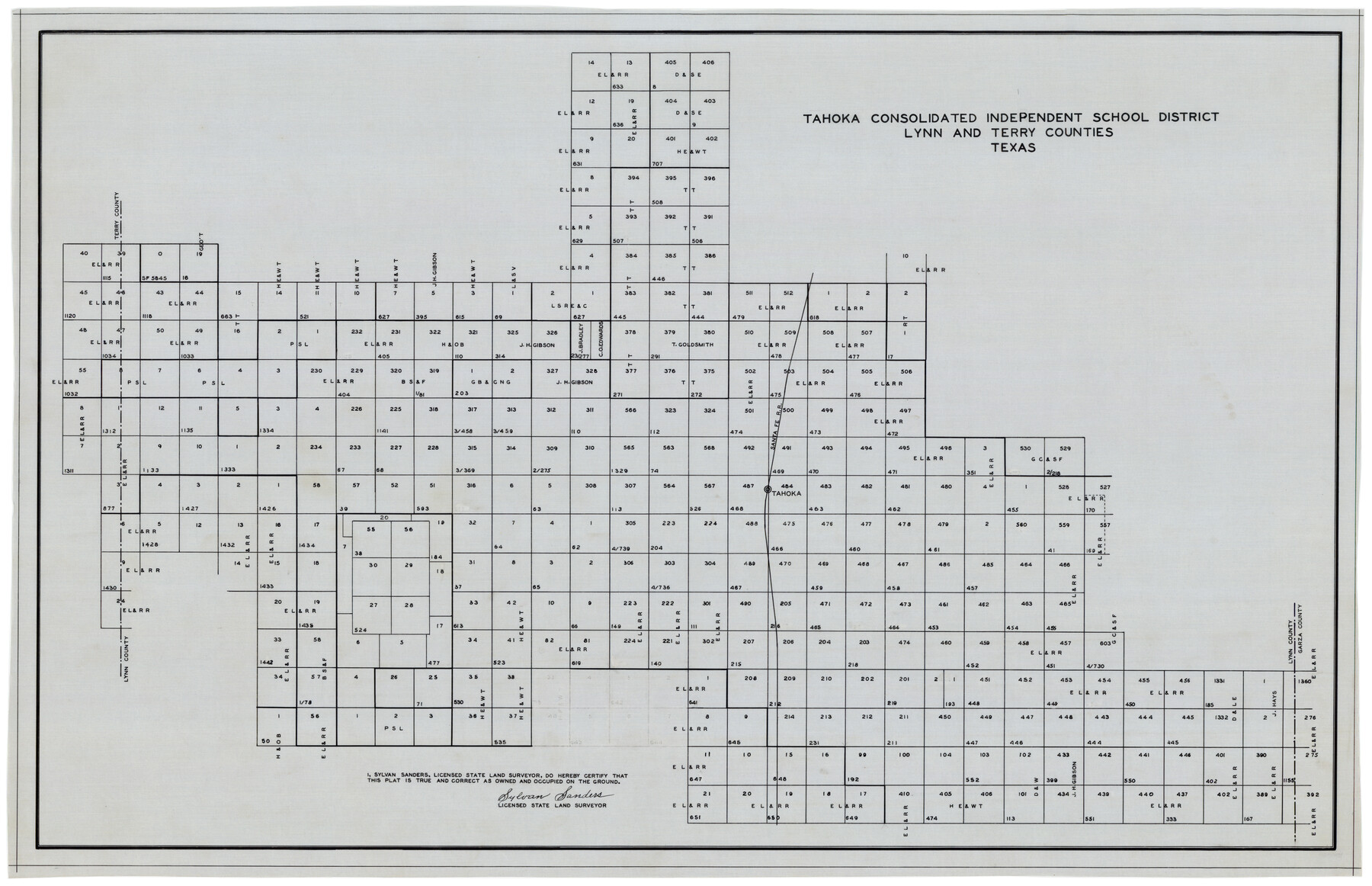
Tahoka Consolidated Independent School District
-
Map/Doc
92943
-
Collection
Twichell Survey Records
-
People and Organizations
Sylvan Sanders (Surveyor/Engineer)
-
Counties
Lynn Terry
-
Height x Width
34.1 x 22.1 inches
86.6 x 56.1 cm
Part of: Twichell Survey Records
[B. S. & F. Block 1 and A. B. & M. Block 2]
![91815, [B. S. & F. Block 1 and A. B. & M. Block 2], Twichell Survey Records](https://historictexasmaps.com/wmedia_w700/maps/91815-1.tif.jpg)
Print $20.00
- Digital $50.00
[B. S. & F. Block 1 and A. B. & M. Block 2]
Size 14.0 x 21.5 inches
Map/Doc 91815
Plat of J. W. Bolin Survey Number 21, Hudspeth County, Texas

Print $3.00
- Digital $50.00
Plat of J. W. Bolin Survey Number 21, Hudspeth County, Texas
1921
Size 15.2 x 10.5 inches
Map/Doc 91133
[Resurvey of Block Number 01- W. H. Godair Surveys]
![92585, [Resurvey of Block Number 01- W. H. Godair Surveys], Twichell Survey Records](https://historictexasmaps.com/wmedia_w700/maps/92585-1.tif.jpg)
Print $20.00
- Digital $50.00
[Resurvey of Block Number 01- W. H. Godair Surveys]
1923
Size 33.9 x 14.9 inches
Map/Doc 92585
The T. B. Duggan Subdivision of League 125 and N 3/5 of League 126, Coke County School Lands, Cochran County, Texas

Print $20.00
- Digital $50.00
The T. B. Duggan Subdivision of League 125 and N 3/5 of League 126, Coke County School Lands, Cochran County, Texas
1920
Size 14.9 x 21.5 inches
Map/Doc 90300
Map of Eastern Portion G.C. & S.F.R.R.Co., Block 194

Print $20.00
- Digital $50.00
Map of Eastern Portion G.C. & S.F.R.R.Co., Block 194
Size 35.6 x 26.8 inches
Map/Doc 92421
Terrell County

Print $20.00
- Digital $50.00
Terrell County
1905
Size 30.7 x 33.8 inches
Map/Doc 92806
A Map of California with Descriptive Notes

A Map of California with Descriptive Notes
1954
Size 29.5 x 37.6 inches
Map/Doc 92394
[Sections 51-80 Block 47 and part of Block 3]
![91810, [Sections 51-80 Block 47 and part of Block 3], Twichell Survey Records](https://historictexasmaps.com/wmedia_w700/maps/91810-1.tif.jpg)
Print $20.00
- Digital $50.00
[Sections 51-80 Block 47 and part of Block 3]
Size 25.0 x 32.8 inches
Map/Doc 91810

Canyon City,Texas, County Seat of Randall County

Print $20.00
- Digital $50.00
Canyon City,Texas, County Seat of Randall County
Size 20.3 x 25.1 inches
Map/Doc 92152

Forester Cemetery

Print $20.00
- Digital $50.00
Forester Cemetery
1925
Size 23.0 x 28.8 inches
Map/Doc 92322
You may also like
Galveston County Rolled Sketch 40A

Print $20.00
- Digital $50.00
Galveston County Rolled Sketch 40A
1988
Size 42.0 x 46.0 inches
Map/Doc 9020
Coast Chart No. 212 - From Latitude 26° 33' to the Rio Grande Texas

Print $20.00
- Digital $50.00
Coast Chart No. 212 - From Latitude 26° 33' to the Rio Grande Texas
1886
Size 18.3 x 24.3 inches
Map/Doc 72836
Culberson County Rolled Sketch 66

Print $20.00
- Digital $50.00
Culberson County Rolled Sketch 66
1987
Size 24.4 x 19.7 inches
Map/Doc 5682
Colorado River, Taiton Sheet

Print $6.00
- Digital $50.00
Colorado River, Taiton Sheet
1941
Size 24.4 x 32.8 inches
Map/Doc 65311
Bosque County, Texas School Map

Print $20.00
- Digital $50.00
Bosque County, Texas School Map
1932
Size 40.9 x 36.6 inches
Map/Doc 81918
Morton Independent School District, Cochran County, Texas

Print $20.00
- Digital $50.00
Morton Independent School District, Cochran County, Texas
Size 26.3 x 23.9 inches
Map/Doc 92519
Freestone County Sketch File 25

Print $18.00
- Digital $50.00
Freestone County Sketch File 25
1952
Size 11.3 x 8.6 inches
Map/Doc 23087
Flight Mission No. CRC-4R, Frame 76, Chambers County

Print $20.00
- Digital $50.00
Flight Mission No. CRC-4R, Frame 76, Chambers County
1956
Size 18.8 x 22.4 inches
Map/Doc 84880
Crane County Rolled Sketch 5A

Print $20.00
- Digital $50.00
Crane County Rolled Sketch 5A
1927
Size 38.0 x 46.4 inches
Map/Doc 8678
Flight Mission No. CLL-1N, Frame 103, Willacy County

Print $20.00
- Digital $50.00
Flight Mission No. CLL-1N, Frame 103, Willacy County
1954
Size 18.4 x 22.1 inches
Map/Doc 87037
General Highway Map, Lampasas County, Texas

Print $20.00
General Highway Map, Lampasas County, Texas
1961
Size 18.2 x 24.7 inches
Map/Doc 79563
Galveston County NRC Article 33.136 Sketch 27

Print $126.00
- Digital $50.00
Galveston County NRC Article 33.136 Sketch 27
2003
Size 24.4 x 36.2 inches
Map/Doc 81970