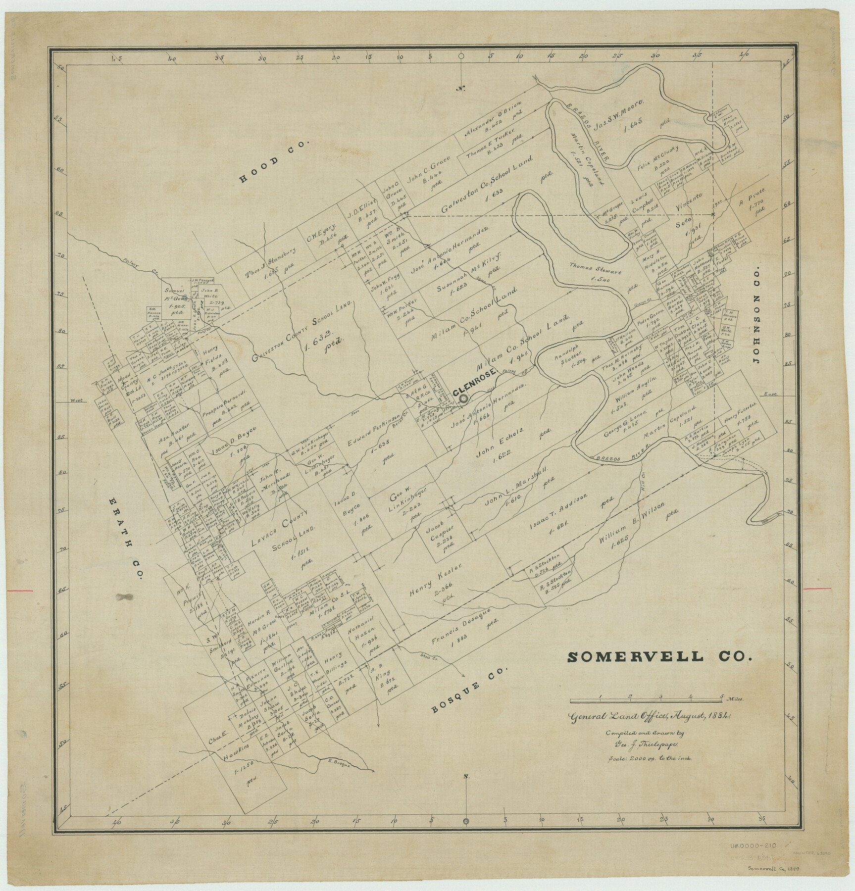
Somervell Co.
-
Map/Doc
63040
-
Collection
General Map Collection
-
Object Dates
1884 (Creation Date)
-
People and Organizations
Texas General Land Office (Publisher)
George J. Thielepape (Draftsman)
George J. Thielepape (Compiler)
-
Counties
Somervell
-
Subjects
County
-
Height x Width
28.0 x 26.8 inches
71.1 x 68.1 cm
Part of: General Map Collection
Walker County Working Sketch 7

Print $20.00
- Digital $50.00
Walker County Working Sketch 7
1935
Size 38.3 x 43.2 inches
Map/Doc 72287
Map of Portion of Matagorda Bay in Matagorda County showing subdivision thereof for mineral development

Print $20.00
- Digital $50.00
Map of Portion of Matagorda Bay in Matagorda County showing subdivision thereof for mineral development
1937
Size 38.3 x 36.6 inches
Map/Doc 2921
Milam County Rolled Sketch 1

Print $20.00
- Digital $50.00
Milam County Rolled Sketch 1
1952
Size 31.2 x 40.3 inches
Map/Doc 6773
Kendall County Working Sketch 7

Print $20.00
- Digital $50.00
Kendall County Working Sketch 7
1950
Size 30.8 x 32.4 inches
Map/Doc 66679

Flight Mission No. BQY-4M, Frame 124, Harris County

Print $20.00
- Digital $50.00
Flight Mission No. BQY-4M, Frame 124, Harris County
1953
Size 18.7 x 22.4 inches
Map/Doc 85292
Zapata County Working Sketch 18

Print $20.00
- Digital $50.00
Zapata County Working Sketch 18
1975
Size 43.2 x 29.1 inches
Map/Doc 62069
Flight Mission No. CRC-2R, Frame 119, Chambers County

Print $20.00
- Digital $50.00
Flight Mission No. CRC-2R, Frame 119, Chambers County
1956
Size 18.6 x 22.4 inches
Map/Doc 84743
Menard County

Print $20.00
- Digital $50.00
Menard County
1942
Size 43.6 x 47.7 inches
Map/Doc 77371
Bee County Sketch File Y

Print $4.00
- Digital $50.00
Bee County Sketch File Y
Size 8.8 x 5.4 inches
Map/Doc 14255
Anderson County Working Sketch 24

Print $20.00
- Digital $50.00
Anderson County Working Sketch 24
1917
Size 16.6 x 15.3 inches
Map/Doc 67024
Crockett County Working Sketch 71

Print $20.00
- Digital $50.00
Crockett County Working Sketch 71
1963
Size 38.7 x 32.7 inches
Map/Doc 68404
You may also like
[Townships 1, 2, 3, Blocks, 62, 61, 60, 59, 58, 57, 56]
![92884, [Townships 1, 2, 3, Blocks, 62, 61, 60, 59, 58, 57, 56], Twichell Survey Records](https://historictexasmaps.com/wmedia_w700/maps/92884-1.tif.jpg)
Print $20.00
- Digital $50.00
[Townships 1, 2, 3, Blocks, 62, 61, 60, 59, 58, 57, 56]
1885
Size 19.1 x 10.3 inches
Map/Doc 92884
Val Verde County Working Sketch 117

Print $20.00
- Digital $50.00
Val Verde County Working Sketch 117
1993
Size 33.8 x 37.0 inches
Map/Doc 82842
Montague County Working Sketch 17

Print $20.00
- Digital $50.00
Montague County Working Sketch 17
1947
Size 22.1 x 30.0 inches
Map/Doc 71083
Nacogdoches County Boundary File 1a

Print $20.00
- Digital $50.00
Nacogdoches County Boundary File 1a
Size 4.7 x 30.5 inches
Map/Doc 57581

Harris County Sketch File 55

Print $20.00
- Digital $50.00
Harris County Sketch File 55
1916
Size 21.8 x 29.7 inches
Map/Doc 11655
Mills County Working Sketch 24

Print $20.00
- Digital $50.00
Mills County Working Sketch 24
1988
Size 40.3 x 36.5 inches
Map/Doc 71054
Matagorda County Sketch File 7a

Print $8.00
- Digital $50.00
Matagorda County Sketch File 7a
1890
Size 14.2 x 8.9 inches
Map/Doc 30740
Hudspeth County Rolled Sketch 50

Print $40.00
- Digital $50.00
Hudspeth County Rolled Sketch 50
1971
Size 56.6 x 34.8 inches
Map/Doc 9220
Reagan County Sketch File 27

Print $8.00
- Digital $50.00
Reagan County Sketch File 27
1949
Size 11.4 x 8.7 inches
Map/Doc 35021
Burnet County Sketch File 8

Print $22.00
- Digital $50.00
Burnet County Sketch File 8
Size 8.1 x 6.3 inches
Map/Doc 16689
El Paso County Working Sketch 40

Print $20.00
- Digital $50.00
El Paso County Working Sketch 40
1992
Size 21.5 x 24.0 inches
Map/Doc 69062