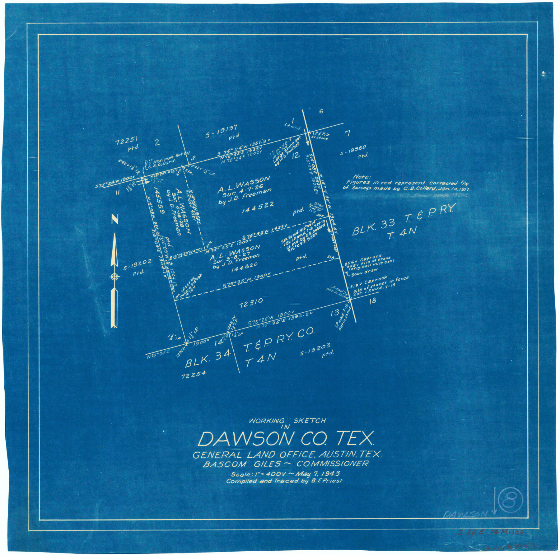
Dawson County Working Sketch 8
-
Map/Doc
68552
-
Collection
General Map Collection
-
Object Dates
5/7/1943 (Creation Date)
-
People and Organizations
B.F. Priest (Draftsman)
-
Counties
Dawson
-
Subjects
Surveying Working Sketch
-
Height x Width
15.3 x 15.4 inches
38.9 x 39.1 cm
-
Scale
1" = 400 varas
Part of: General Map Collection
McMullen County Working Sketch 62

Print $20.00
- Digital $50.00
McMullen County Working Sketch 62
2016
Size 24.1 x 36.1 inches
Map/Doc 94089
Titus County Sketch File 3

Print $40.00
- Digital $50.00
Titus County Sketch File 3
1852
Size 19.9 x 8.4 inches
Map/Doc 38134
Flight Mission No. CUG-1P, Frame 80, Kleberg County

Print $20.00
- Digital $50.00
Flight Mission No. CUG-1P, Frame 80, Kleberg County
1956
Size 18.8 x 22.4 inches
Map/Doc 86145
El Paso County Working Sketch 27

Print $20.00
- Digital $50.00
El Paso County Working Sketch 27
1963
Size 34.2 x 13.2 inches
Map/Doc 69049
McLennan County Sketch File 41

Print $44.00
- Digital $50.00
McLennan County Sketch File 41
1963
Size 11.1 x 8.6 inches
Map/Doc 31319
Angelina County Sketch File 21b

Print $6.00
- Digital $50.00
Angelina County Sketch File 21b
1889
Size 13.9 x 8.5 inches
Map/Doc 13044
Lipscomb County Boundary File 6

Print $4.00
- Digital $50.00
Lipscomb County Boundary File 6
Size 11.1 x 8.6 inches
Map/Doc 56329
Cooke County Boundary File 1

Print $4.00
- Digital $50.00
Cooke County Boundary File 1
Size 12.6 x 7.5 inches
Map/Doc 51826
Sutton County Sketch File 41

Print $4.00
- Digital $50.00
Sutton County Sketch File 41
1940
Size 14.4 x 8.6 inches
Map/Doc 37507
The American Military Pocket Atlas; being an approved Collection of Correct Maps, both general and particular, of the British Colonies; Especially those which now are, or probably may be the Theatre of War

The American Military Pocket Atlas; being an approved Collection of Correct Maps, both general and particular, of the British Colonies; Especially those which now are, or probably may be the Theatre of War
1776
Map/Doc 97398
Young County Working Sketch 1

Print $20.00
- Digital $50.00
Young County Working Sketch 1
1960
Size 31.1 x 41.9 inches
Map/Doc 62024
Schleicher County Rolled Sketch 8

Print $20.00
- Digital $50.00
Schleicher County Rolled Sketch 8
Size 27.8 x 29.0 inches
Map/Doc 7750
You may also like
Starr County Working Sketch Graphic Index

Print $40.00
- Digital $50.00
Starr County Working Sketch Graphic Index
1977
Size 43.0 x 55.5 inches
Map/Doc 76701
Henderson County Working Sketch 31

Print $20.00
- Digital $50.00
Henderson County Working Sketch 31
1962
Size 38.7 x 39.6 inches
Map/Doc 66164
Reeves County Working Sketch 65

Print $20.00
- Digital $50.00
Reeves County Working Sketch 65
1990
Size 17.3 x 19.7 inches
Map/Doc 63508
Maps of Gulf Intracoastal Waterway, Texas - Sabine River to the Rio Grande and connecting waterways including ship channels

Print $20.00
- Digital $50.00
Maps of Gulf Intracoastal Waterway, Texas - Sabine River to the Rio Grande and connecting waterways including ship channels
1966
Size 15.6 x 22.0 inches
Map/Doc 61984
Fisher County Rolled Sketch 5

Print $20.00
- Digital $50.00
Fisher County Rolled Sketch 5
1961
Size 39.1 x 33.7 inches
Map/Doc 8890
Flight Mission No. CUG-2P, Frame 66, Kleberg County

Print $20.00
- Digital $50.00
Flight Mission No. CUG-2P, Frame 66, Kleberg County
1956
Size 18.5 x 22.2 inches
Map/Doc 86203
McMullen County Working Sketch 8

Print $20.00
- Digital $50.00
McMullen County Working Sketch 8
1936
Size 27.2 x 33.0 inches
Map/Doc 70709
Polk County Rolled Sketch 27

Print $20.00
- Digital $50.00
Polk County Rolled Sketch 27
1944
Size 21.1 x 26.6 inches
Map/Doc 7315
Galveston County NRC Article 33.136 Sketch 58

Print $26.00
- Digital $50.00
Galveston County NRC Article 33.136 Sketch 58
2009
Size 12.0 x 17.6 inches
Map/Doc 94592
Kimble County Working Sketch 64

Print $20.00
- Digital $50.00
Kimble County Working Sketch 64
1964
Size 15.1 x 16.9 inches
Map/Doc 70132
Wharton County Working Sketch 15

Print $20.00
- Digital $50.00
Wharton County Working Sketch 15
1957
Size 22.1 x 25.9 inches
Map/Doc 72479
Colorado River, Carancahua Sheet

Print $20.00
- Digital $50.00
Colorado River, Carancahua Sheet
1940
Size 30.7 x 38.0 inches
Map/Doc 65320