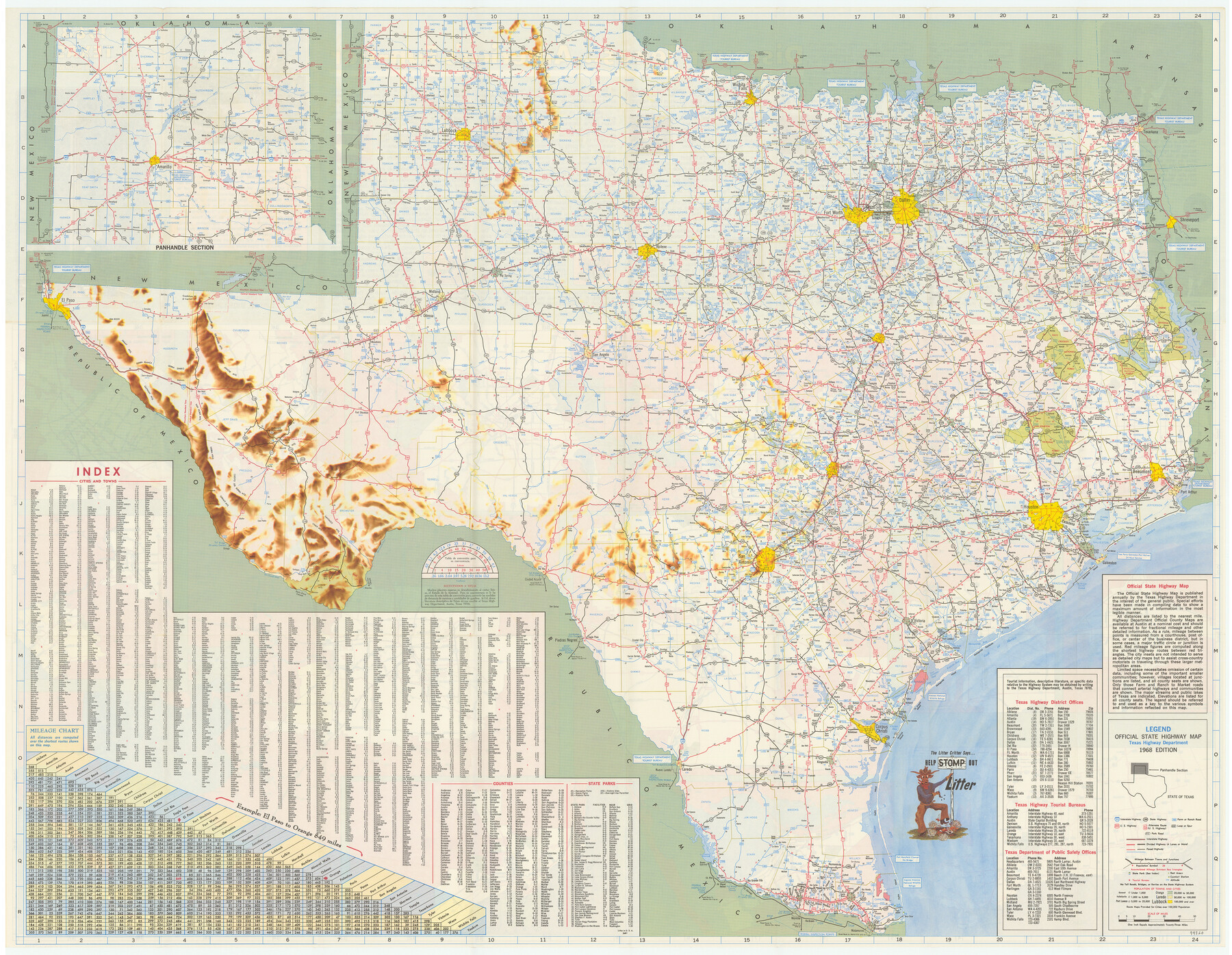
1968 Texas Official State Highway Map
[Verso - Map of Texas]
-
Map/Doc
94320
-
Collection
General Map Collection
-
Object Dates
1968 (Edition Date)
-
People and Organizations
Texas Highway Department (Publisher)
-
Subjects
State of Texas
-
Height x Width
28.2 x 36.3 inches
71.6 x 92.2 cm
-
Medium
paper, etching/engraving/lithograph
-
Comments
For map of various Texas cities on recto see 94319. For reseach purposes only.
Related maps
1968 Texas Official State Highway Map

Digital $50.00
1968 Texas Official State Highway Map
Size 28.1 x 36.5 inches
Map/Doc 94319
Part of: General Map Collection
Crockett County Rolled Sketch 16

Print $20.00
- Digital $50.00
Crockett County Rolled Sketch 16
1880
Size 36.2 x 26.2 inches
Map/Doc 5581

Hartley County Rolled Sketch 5

Print $20.00
- Digital $50.00
Hartley County Rolled Sketch 5
Size 26.1 x 22.0 inches
Map/Doc 6160
Scurry County Working Sketch 8

Print $40.00
- Digital $50.00
Scurry County Working Sketch 8
1980
Size 34.5 x 49.5 inches
Map/Doc 63837
Limestone County Sketch File 11

Print $4.00
- Digital $50.00
Limestone County Sketch File 11
1881
Size 7.9 x 9.5 inches
Map/Doc 30177

Flight Mission No. BQR-13K, Frame 118, Brazoria County

Print $20.00
- Digital $50.00
Flight Mission No. BQR-13K, Frame 118, Brazoria County
1952
Size 18.6 x 22.4 inches
Map/Doc 84079
Pecos County Sketch File 43

Print $20.00
- Digital $50.00
Pecos County Sketch File 43
Size 16.1 x 30.4 inches
Map/Doc 12178
Goliad County Working Sketch 15

Print $20.00
- Digital $50.00
Goliad County Working Sketch 15
1948
Size 42.9 x 43.6 inches
Map/Doc 63205
Medina County Working Sketch 1

Print $20.00
- Digital $50.00
Medina County Working Sketch 1
1915
Size 14.2 x 14.2 inches
Map/Doc 70916
Stephens County Rolled Sketch 6

Print $20.00
- Digital $50.00
Stephens County Rolled Sketch 6
Size 37.1 x 36.0 inches
Map/Doc 8360
Current Miscellaneous File 51

Print $6.00
- Digital $50.00
Current Miscellaneous File 51
Size 11.6 x 9.2 inches
Map/Doc 74029
You may also like
[T. & P. Block 43, Township 1N]
![90827, [T. & P. Block 43, Township 1N], Twichell Survey Records](https://historictexasmaps.com/wmedia_w700/maps/90827-2.tif.jpg)
Print $20.00
- Digital $50.00
[T. & P. Block 43, Township 1N]
Size 23.0 x 17.8 inches
Map/Doc 90827
Flight Mission No. CUG-1P, Frame 171, Kleberg County

Print $20.00
- Digital $50.00
Flight Mission No. CUG-1P, Frame 171, Kleberg County
1956
Size 18.5 x 22.1 inches
Map/Doc 86178
Galveston County Sketch File 74

Print $12.00
- Digital $50.00
Galveston County Sketch File 74
2002
Size 11.3 x 8.7 inches
Map/Doc 77526
Ochiltree County State of Texas

Print $20.00
- Digital $50.00
Ochiltree County State of Texas
1889
Size 25.5 x 19.0 inches
Map/Doc 4609
Presidio County Working Sketch 112

Print $20.00
- Digital $50.00
Presidio County Working Sketch 112
1979
Size 41.7 x 35.6 inches
Map/Doc 71789
Zapata County Rolled Sketch 24

Print $20.00
- Digital $50.00
Zapata County Rolled Sketch 24
Size 38.8 x 28.0 inches
Map/Doc 8318
Howard T. Trigg's Official Map of Amarillo

Print $40.00
- Digital $50.00
Howard T. Trigg's Official Map of Amarillo
Size 79.1 x 54.0 inches
Map/Doc 93196
McMullen County Working Sketch 40

Print $40.00
- Digital $50.00
McMullen County Working Sketch 40
1975
Size 48.3 x 34.8 inches
Map/Doc 70741
Wichita County Sketch File 31

Print $20.00
- Digital $50.00
Wichita County Sketch File 31
1938
Size 27.6 x 39.4 inches
Map/Doc 10433
Texas Gulf Coast Map from the Sabine River to the Rio Grande as subdivided for mineral development

Print $40.00
- Digital $50.00
Texas Gulf Coast Map from the Sabine River to the Rio Grande as subdivided for mineral development
1948
Size 60.9 x 36.7 inches
Map/Doc 2909
Trinity County Sketch File 35a

Print $6.00
- Digital $50.00
Trinity County Sketch File 35a
1921
Size 16.8 x 8.8 inches
Map/Doc 38587
Henderson County Working Sketch 4

Print $20.00
- Digital $50.00
Henderson County Working Sketch 4
1918
Size 21.2 x 16.0 inches
Map/Doc 66137