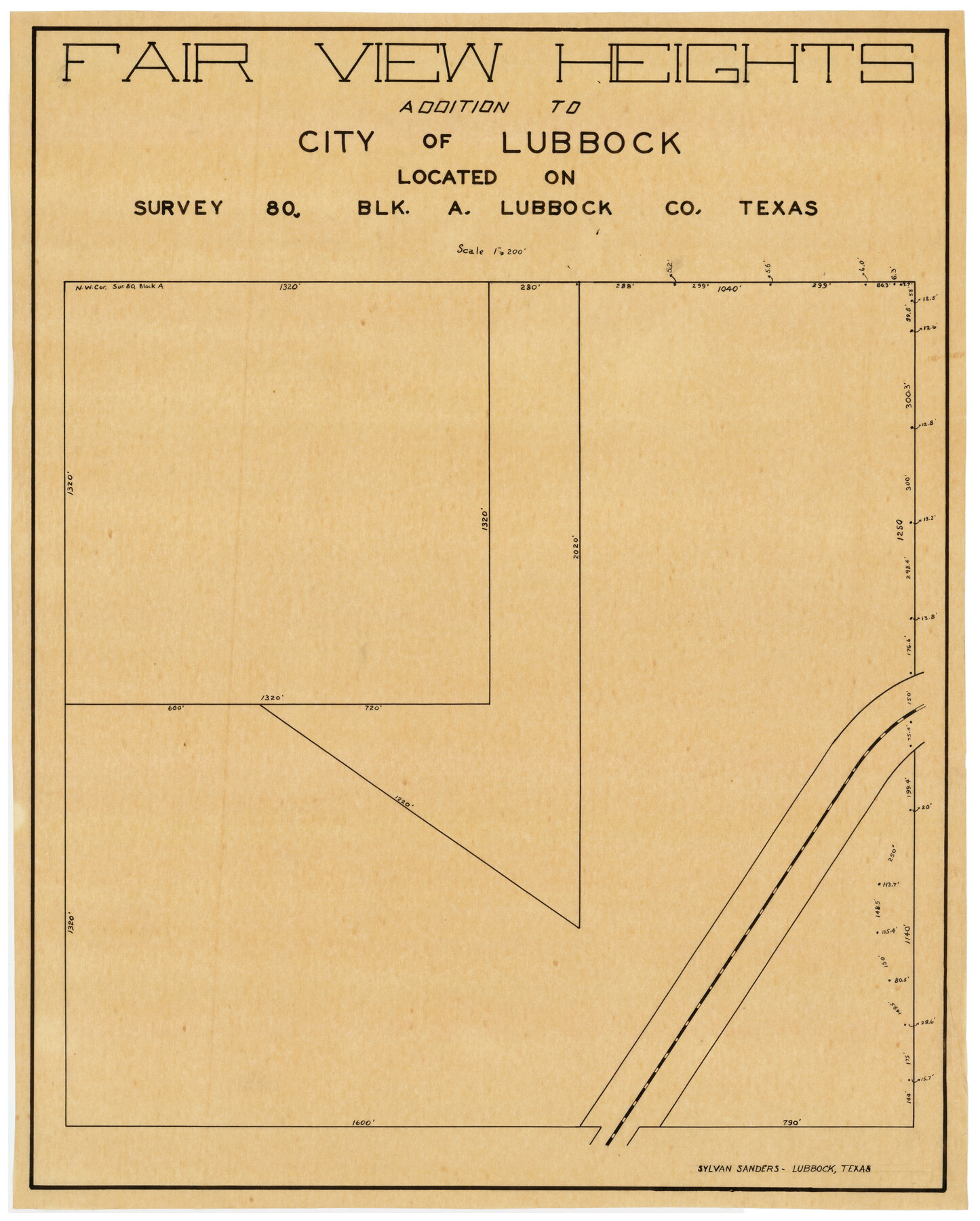
Fair View Heights Addition to City of Lubbock Located on Survey 80, Blk. A
-
Map/Doc
92770
-
Collection
Twichell Survey Records
-
People and Organizations
Sylvan Sanders (Surveyor/Engineer)
-
Counties
Lubbock
-
Height x Width
15.5 x 19.5 inches
39.4 x 49.5 cm
Part of: Twichell Survey Records
[Sketch Showing Wm. T. Brewer, John R. Taylor, Wm. F. Butler, Timothy DeVore, L. M. Thorn and adjoining surveys]
![90231, [Sketch Showing Wm. T. Brewer, John R. Taylor, Wm. F. Butler, Timothy DeVore, L. M. Thorn and adjoining surveys], Twichell Survey Records](https://historictexasmaps.com/wmedia_w700/maps/90231-1.tif.jpg)
Print $20.00
- Digital $50.00
[Sketch Showing Wm. T. Brewer, John R. Taylor, Wm. F. Butler, Timothy DeVore, L. M. Thorn and adjoining surveys]
Size 27.2 x 19.4 inches
Map/Doc 90231

[H. & G. N. Block 1]
![90810, [H. & G. N. Block 1], Twichell Survey Records](https://historictexasmaps.com/wmedia_w700/maps/90810-2.tif.jpg)
Print $3.00
- Digital $50.00
[H. & G. N. Block 1]
Size 11.4 x 12.9 inches
Map/Doc 90810
[West half of county, south of John H. Stephens Block S2]
![92976, [West half of county, south of John H. Stephens Block S2], Twichell Survey Records](https://historictexasmaps.com/wmedia_w700/maps/92976-1.tif.jpg)
Print $2.00
- Digital $50.00
[West half of county, south of John H. Stephens Block S2]
1912
Size 8.6 x 5.9 inches
Map/Doc 92976
Sketch for Blocks D6, D7, D8 situated in Val Verde County, Texas

Print $40.00
- Digital $50.00
Sketch for Blocks D6, D7, D8 situated in Val Verde County, Texas
1937
Size 100.1 x 40.0 inches
Map/Doc 93166
[Survey 9, Block 9 Potter and Randall]
![91720, [Survey 9, Block 9 Potter and Randall], Twichell Survey Records](https://historictexasmaps.com/wmedia_w700/maps/91720-1.tif.jpg)
Print $20.00
- Digital $50.00
[Survey 9, Block 9 Potter and Randall]
Size 22.3 x 15.9 inches
Map/Doc 91720
Map of C. C. Slaughter Cattle Co.'s Ranch, Cochran-Hockley Counties, Texas

Print $20.00
- Digital $50.00
Map of C. C. Slaughter Cattle Co.'s Ranch, Cochran-Hockley Counties, Texas
Size 27.4 x 20.3 inches
Map/Doc 90439
[Western part of Crockett County]
![90323, [Western part of Crockett County], Twichell Survey Records](https://historictexasmaps.com/wmedia_w700/maps/90323-1.tif.jpg)
Print $20.00
- Digital $50.00
[Western part of Crockett County]
Size 17.3 x 14.3 inches
Map/Doc 90323
[Sections 158-162 and surveys to the east]
![93003, [Sections 158-162 and surveys to the east], Twichell Survey Records](https://historictexasmaps.com/wmedia_w700/maps/93003-1.tif.jpg)
Print $20.00
- Digital $50.00
[Sections 158-162 and surveys to the east]
1916
Size 7.8 x 18.9 inches
Map/Doc 93003
South Umbarger in Randall County, Texas

Print $20.00
- Digital $50.00
South Umbarger in Randall County, Texas
1905
Size 31.2 x 30.7 inches
Map/Doc 92153
Working Sketch Showing Scrap Lands in Hale County

Print $20.00
- Digital $50.00
Working Sketch Showing Scrap Lands in Hale County
1915
Size 22.7 x 11.1 inches
Map/Doc 90742
Carter-Coffey Addition, Part of Section 77, Block A

Print $20.00
- Digital $50.00
Carter-Coffey Addition, Part of Section 77, Block A
Size 30.0 x 9.8 inches
Map/Doc 92766
You may also like
Andrews County Sketch File 19

Print $12.00
- Digital $50.00
Andrews County Sketch File 19
Size 14.3 x 8.8 inches
Map/Doc 12912
Gillespie County Working Sketch Graphic Index

Print $20.00
- Digital $50.00
Gillespie County Working Sketch Graphic Index
1945
Size 38.0 x 47.4 inches
Map/Doc 76553
Atascosa County Working Sketch 19

Print $20.00
- Digital $50.00
Atascosa County Working Sketch 19
1952
Size 24.4 x 27.3 inches
Map/Doc 67215
Robertson County Sketch File 10 (1)

Print $3.00
- Digital $50.00
Robertson County Sketch File 10 (1)
Size 13.0 x 10.4 inches
Map/Doc 43369
General Highway Map. Detail of Cities and Towns in Falls County, Texas

Print $20.00
General Highway Map. Detail of Cities and Towns in Falls County, Texas
1961
Size 18.1 x 24.4 inches
Map/Doc 79463
Cass County Working Sketch 27

Print $20.00
- Digital $50.00
Cass County Working Sketch 27
1978
Size 17.5 x 19.7 inches
Map/Doc 67930
Cherokee County Rolled Sketch 4

Print $20.00
- Digital $50.00
Cherokee County Rolled Sketch 4
1972
Size 30.7 x 23.6 inches
Map/Doc 5436
University of Texas System University Lands

Print $20.00
- Digital $50.00
University of Texas System University Lands
1938
Size 17.8 x 23.4 inches
Map/Doc 93247
Castro County Sketch File 14

Print $40.00
- Digital $50.00
Castro County Sketch File 14
1971
Size 13.9 x 25.1 inches
Map/Doc 11061
Travis County Appraisal District Plat Map 2_1709

Print $20.00
- Digital $50.00
Travis County Appraisal District Plat Map 2_1709
Size 21.6 x 26.5 inches
Map/Doc 94210
The City of Austin and Suburbs

Print $40.00
- Digital $50.00
The City of Austin and Suburbs
1919
Size 120.7 x 43.9 inches
Map/Doc 88862
Tyler County Working Sketch 10

Print $20.00
- Digital $50.00
Tyler County Working Sketch 10
1937
Size 24.0 x 24.1 inches
Map/Doc 69480