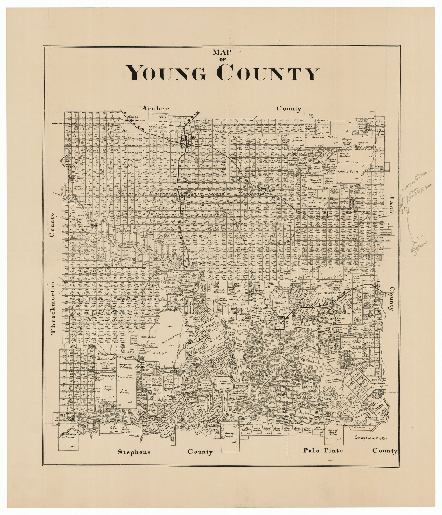
Map of Young County
-
Map/Doc
92108
-
Collection
Twichell Survey Records
-
Counties
Young
-
Subjects
County
-
Height x Width
16.9 x 19.7 inches
42.9 x 50.0 cm
Part of: Twichell Survey Records
[Part of Block K11, Leagues 346, 357 1/2, 367]
![90530, [Part of Block K11, Leagues 346, 357 1/2, 367], Twichell Survey Records](https://historictexasmaps.com/wmedia_w700/maps/90530-1.tif.jpg)
Print $2.00
- Digital $50.00
[Part of Block K11, Leagues 346, 357 1/2, 367]
Size 7.3 x 11.6 inches
Map/Doc 90530
[I. & G. N. RR. Co. Blk. 6, Blks M8, M9 and M10]
![90267, [I. & G. N. RR. Co. Blk. 6, Blks M8, M9 and M10], Twichell Survey Records](https://historictexasmaps.com/wmedia_w700/maps/90267-1.tif.jpg)
Print $20.00
- Digital $50.00
[I. & G. N. RR. Co. Blk. 6, Blks M8, M9 and M10]
Size 34.2 x 20.3 inches
Map/Doc 90267
[Sections 77-114, Block 47 and part of G. & M. Blocks 2 and 3]
![91827, [Sections 77-114, Block 47 and part of G. & M. Blocks 2 and 3], Twichell Survey Records](https://historictexasmaps.com/wmedia_w700/maps/91827-1.tif.jpg)
Print $20.00
- Digital $50.00
[Sections 77-114, Block 47 and part of G. & M. Blocks 2 and 3]
Size 38.1 x 19.8 inches
Map/Doc 91827
Sec. 22, Block 103

Print $20.00
- Digital $50.00
Sec. 22, Block 103
Size 13.1 x 14.8 inches
Map/Doc 90120
[Sketch of counties just south of the Panhandle]
![90913, [Sketch of counties just south of the Panhandle], Twichell Survey Records](https://historictexasmaps.com/wmedia_w700/maps/90913-1.tif.jpg)
Print $20.00
- Digital $50.00
[Sketch of counties just south of the Panhandle]
Size 42.7 x 34.8 inches
Map/Doc 90913
Subdivision of Sutton County School League 175. Bailey County, Texas

Print $2.00
- Digital $50.00
Subdivision of Sutton County School League 175. Bailey County, Texas
1929
Size 9.1 x 11.5 inches
Map/Doc 90278
[Sabine County School Land and vicinity]
![90981, [Sabine County School Land and vicinity], Twichell Survey Records](https://historictexasmaps.com/wmedia_w700/maps/90981-1.tif.jpg)
Print $20.00
- Digital $50.00
[Sabine County School Land and vicinity]
Size 18.1 x 19.9 inches
Map/Doc 90981
Part of Block T-2 Lamb County Texas

Print $20.00
- Digital $50.00
Part of Block T-2 Lamb County Texas
1952
Size 14.3 x 24.6 inches
Map/Doc 92182

[Pencil sketch showing blocks B17, B20-B28 and surrounding]
![89734, [Pencil sketch showing blocks B17, B20-B28 and surrounding], Twichell Survey Records](https://historictexasmaps.com/wmedia_w700/maps/89734-1.tif.jpg)
Print $40.00
- Digital $50.00
[Pencil sketch showing blocks B17, B20-B28 and surrounding]
Size 58.5 x 40.0 inches
Map/Doc 89734
[State Line from Southeast New Mexico to Yoakum County]
![92013, [State Line from Southeast New Mexico to Yoakum County], Twichell Survey Records](https://historictexasmaps.com/wmedia_w700/maps/92013-1.tif.jpg)
Print $20.00
- Digital $50.00
[State Line from Southeast New Mexico to Yoakum County]
Size 32.3 x 11.7 inches
Map/Doc 92013
[3KA and vicinity]
![90846, [3KA and vicinity], Twichell Survey Records](https://historictexasmaps.com/wmedia_w700/maps/90846-2.tif.jpg)
Print $20.00
- Digital $50.00
[3KA and vicinity]
Size 32.9 x 10.3 inches
Map/Doc 90846
You may also like
[Sketch showing Northwest corner of Fisher County, Northeast corner of Scurry County and South part of Kent County]
![90917, [Sketch showing Northwest corner of Fisher County, Northeast corner of Scurry County and South part of Kent County], Twichell Survey Records](https://historictexasmaps.com/wmedia_w700/maps/90917-1.tif.jpg)
Print $20.00
- Digital $50.00
[Sketch showing Northwest corner of Fisher County, Northeast corner of Scurry County and South part of Kent County]
1900
Size 17.7 x 15.0 inches
Map/Doc 90917
[St. L. S-W. Ry. of Texas Map of Lufkin Branch in Cherokee County Texas]
![64018, [St. L. S-W. Ry. of Texas Map of Lufkin Branch in Cherokee County Texas], General Map Collection](https://historictexasmaps.com/wmedia_w700/maps/64018.tif.jpg)
Print $40.00
- Digital $50.00
[St. L. S-W. Ry. of Texas Map of Lufkin Branch in Cherokee County Texas]
1912
Size 22.3 x 121.1 inches
Map/Doc 64018
Right of Way and Track Map, International & Gt. Northern Ry. operated by the International & Gt. Northern Ry. Co. Gulf Division, Mineola Branch

Print $40.00
- Digital $50.00
Right of Way and Track Map, International & Gt. Northern Ry. operated by the International & Gt. Northern Ry. Co. Gulf Division, Mineola Branch
1917
Size 24.9 x 60.2 inches
Map/Doc 64705


Anderson County Working Sketch 47

Print $40.00
- Digital $50.00
Anderson County Working Sketch 47
2012
Size 49.1 x 37.0 inches
Map/Doc 93396
Val Verde County Sketch File AAA3

Print $20.00
- Digital $50.00
Val Verde County Sketch File AAA3
Size 19.1 x 19.2 inches
Map/Doc 12541
Webb County Working Sketch 71

Print $40.00
- Digital $50.00
Webb County Working Sketch 71
1973
Size 46.1 x 95.8 inches
Map/Doc 72438
Val Verde County Sketch File 22

Print $20.00
- Digital $50.00
Val Verde County Sketch File 22
Size 14.3 x 22.3 inches
Map/Doc 12571
Map Showing East Part Pecos County, Texas with Blocks 194 and 178 Constructed and Adjusted to the Ground Distance from NE 36 Block 12 H&GN to Pecos Spring and by Original Field Note Calls from Pecos Spring to NE 75 Blk. 1 I&GN

Print $40.00
- Digital $50.00
Map Showing East Part Pecos County, Texas with Blocks 194 and 178 Constructed and Adjusted to the Ground Distance from NE 36 Block 12 H&GN to Pecos Spring and by Original Field Note Calls from Pecos Spring to NE 75 Blk. 1 I&GN
Size 45.0 x 51.4 inches
Map/Doc 89838
Brewster County Rolled Sketch 108

Print $20.00
- Digital $50.00
Brewster County Rolled Sketch 108
1958
Size 29.8 x 17.1 inches
Map/Doc 5260
[Blocks A, RG, O, B and 11]
![92861, [Blocks A, RG, O, B and 11], Twichell Survey Records](https://historictexasmaps.com/wmedia_w700/maps/92861-1.tif.jpg)
Print $20.00
- Digital $50.00
[Blocks A, RG, O, B and 11]
Size 21.0 x 18.1 inches
Map/Doc 92861