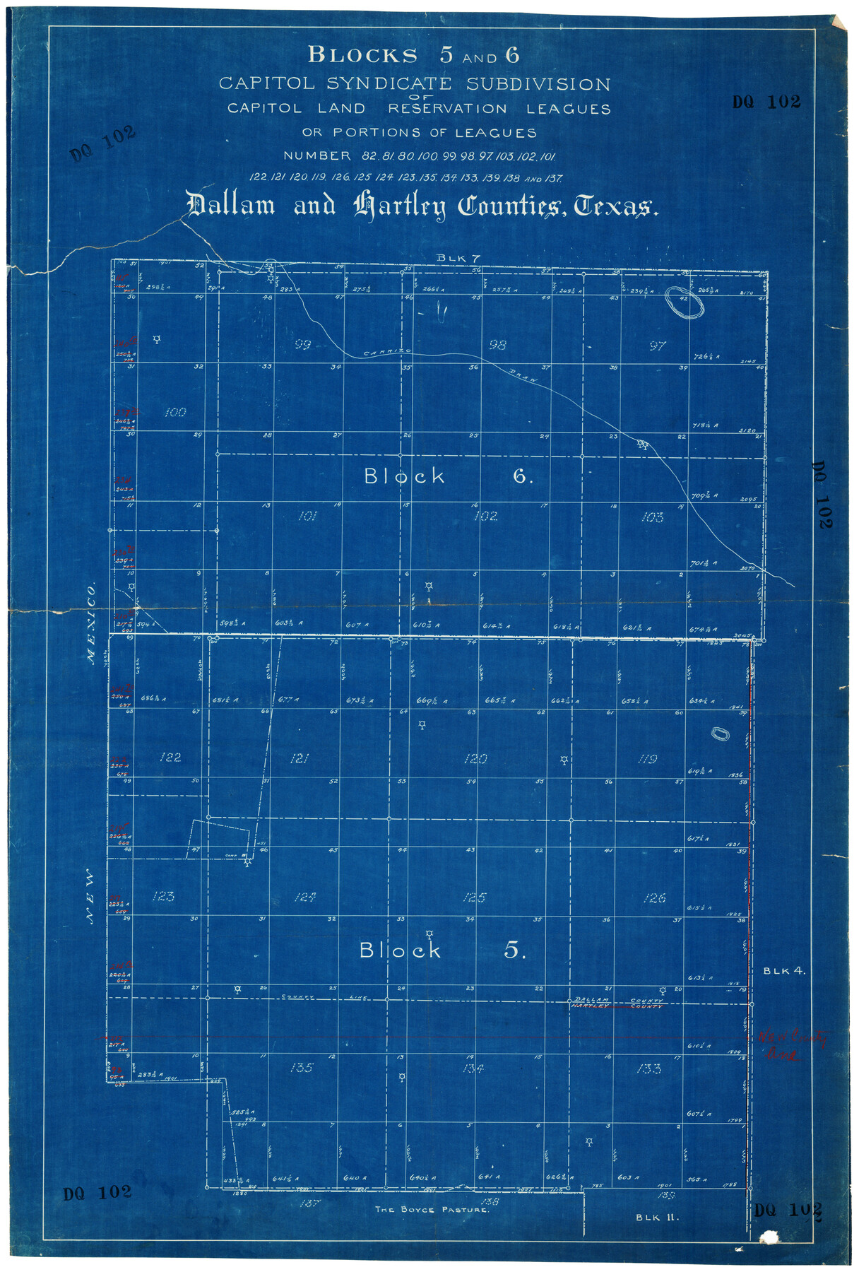
Blocks 5 and 6 Capitol Syndicate Subdivision of Capitol Land Reservation Leagues or Portions of Leagues Number 82, 81, 80, 100, 99, 98, 97, 103, 102, 101, 122, 121, 120, 119, 126, 125, 124, 123, 135, 134, 133, 139, 138, and 137
DQ102
-
Map/Doc
92580
-
Collection
Twichell Survey Records
-
Counties
Dallam Hartley
-
Height x Width
24.1 x 35.5 inches
61.2 x 90.2 cm
Part of: Twichell Survey Records
[R. T. Bucy's Survey 3, League 321]
![91296, [R. T. Bucy's Survey 3, League 321], Twichell Survey Records](https://historictexasmaps.com/wmedia_w700/maps/91296-1.tif.jpg)
Print $20.00
- Digital $50.00
[R. T. Bucy's Survey 3, League 321]
Size 12.2 x 19.1 inches
Map/Doc 91296

[Sketch showing surveys in Blocks 70, 71 and 72 surrounding the town of Toyah]
![91835, [Sketch showing surveys in Blocks 70, 71 and 72 surrounding the town of Toyah], Twichell Survey Records](https://historictexasmaps.com/wmedia_w700/maps/91835-1.tif.jpg)
Print $20.00
- Digital $50.00
[Sketch showing surveys in Blocks 70, 71 and 72 surrounding the town of Toyah]
Size 44.1 x 24.0 inches
Map/Doc 91835
[Eastern Texas RR. Co. Block 1]
![91922, [Eastern Texas RR. Co. Block 1], Twichell Survey Records](https://historictexasmaps.com/wmedia_w700/maps/91922-1.tif.jpg)
Print $20.00
- Digital $50.00
[Eastern Texas RR. Co. Block 1]
Size 34.7 x 31.0 inches
Map/Doc 91922
Block 2, John W. Jarrotts Subdivision

Print $20.00
- Digital $50.00
Block 2, John W. Jarrotts Subdivision
1950
Size 15.1 x 13.7 inches
Map/Doc 92713
[Sketch showing Potter County Block 2] / [Sketch showing F. W. & D. C. Round House]
![91709, [Sketch showing Potter County Block 2] / [Sketch showing F. W. & D. C. Round House], Twichell Survey Records](https://historictexasmaps.com/wmedia_w700/maps/91709-1.tif.jpg)
Print $20.00
- Digital $50.00
[Sketch showing Potter County Block 2] / [Sketch showing F. W. & D. C. Round House]
Size 12.2 x 14.6 inches
Map/Doc 91709
Part of South Half of Section 4, Block O

Print $20.00
- Digital $50.00
Part of South Half of Section 4, Block O
1953
Size 21.1 x 17.2 inches
Map/Doc 92780
[Part of Map Showing Terry & Lynn County Line Highlighting Parts of Blocks D8, E, 9]
![92264, [Part of Map Showing Terry & Lynn County Line Highlighting Parts of Blocks D8, E, 9], Twichell Survey Records](https://historictexasmaps.com/wmedia_w700/maps/92264-1.tif.jpg)
Print $20.00
- Digital $50.00
[Part of Map Showing Terry & Lynn County Line Highlighting Parts of Blocks D8, E, 9]
Size 18.2 x 10.9 inches
Map/Doc 92264
![92632, [League 280], Twichell Survey Records](https://historictexasmaps.com/wmedia_w700/maps/92632-1.tif.jpg)
Section L Tech Memorial Park, Inc.

Print $20.00
- Digital $50.00
Section L Tech Memorial Park, Inc.
1950
Size 17.7 x 19.5 inches
Map/Doc 92350
Map of Adrian, the New Town in the Panhandle, Oldham County, Texas

Print $20.00
- Digital $50.00
Map of Adrian, the New Town in the Panhandle, Oldham County, Texas
Size 21.5 x 25.8 inches
Map/Doc 92135
Sheet 1 copied from Peck Book 6 [Strip Map showing T. & P. connecting lines]
![93169, Sheet 1 copied from Peck Book 6 [Strip Map showing T. & P. connecting lines], Twichell Survey Records](https://historictexasmaps.com/wmedia_w700/maps/93169-1.tif.jpg)
Print $40.00
- Digital $50.00
Sheet 1 copied from Peck Book 6 [Strip Map showing T. & P. connecting lines]
1909
Size 6.8 x 83.1 inches
Map/Doc 93169
You may also like
Orange County Rolled Sketch 32

Print $20.00
- Digital $50.00
Orange County Rolled Sketch 32
1982
Size 33.6 x 22.5 inches
Map/Doc 7188
Tarrant County Sketch File 8

Print $4.00
- Digital $50.00
Tarrant County Sketch File 8
1858
Size 8.1 x 10.1 inches
Map/Doc 37687
Potter County Working Sketch 9

Print $40.00
- Digital $50.00
Potter County Working Sketch 9
1966
Size 46.4 x 48.6 inches
Map/Doc 71669
Hudspeth County Working Sketch 59

Print $20.00
- Digital $50.00
Hudspeth County Working Sketch 59
1992
Size 24.3 x 33.4 inches
Map/Doc 66344
McLennan County Sketch File 42

Print $24.00
- Digital $50.00
McLennan County Sketch File 42
1868
Size 7.8 x 7.1 inches
Map/Doc 31331
Denton County Sketch File 28

Print $4.00
- Digital $50.00
Denton County Sketch File 28
Size 14.4 x 8.9 inches
Map/Doc 20756
Brewster County Sketch File D-1

Print $12.00
- Digital $50.00
Brewster County Sketch File D-1
1909
Size 14.4 x 8.8 inches
Map/Doc 15740
Uvalde County Working Sketch 64

Print $20.00
- Digital $50.00
Uvalde County Working Sketch 64
1998
Size 29.9 x 30.6 inches
Map/Doc 72134
Cooke County Working Sketch 11
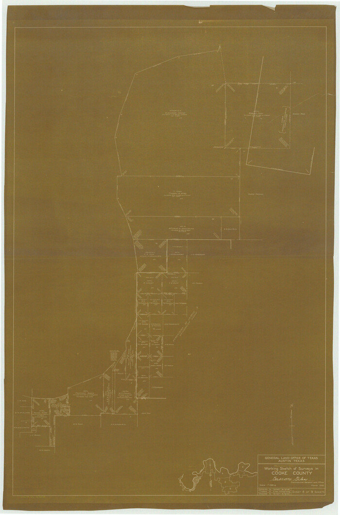
Print $20.00
- Digital $50.00
Cooke County Working Sketch 11
1940
Size 42.6 x 28.2 inches
Map/Doc 68248
Midland County Working Sketch 1

Print $20.00
- Digital $50.00
Midland County Working Sketch 1
Size 26.8 x 8.7 inches
Map/Doc 70981
Shelby County Working Sketch 30

Print $20.00
- Digital $50.00
Shelby County Working Sketch 30
2000
Size 35.9 x 44.7 inches
Map/Doc 63885
Baylor County Sketch File 22

Print $10.00
- Digital $50.00
Baylor County Sketch File 22
1913
Size 11.2 x 8.8 inches
Map/Doc 14199