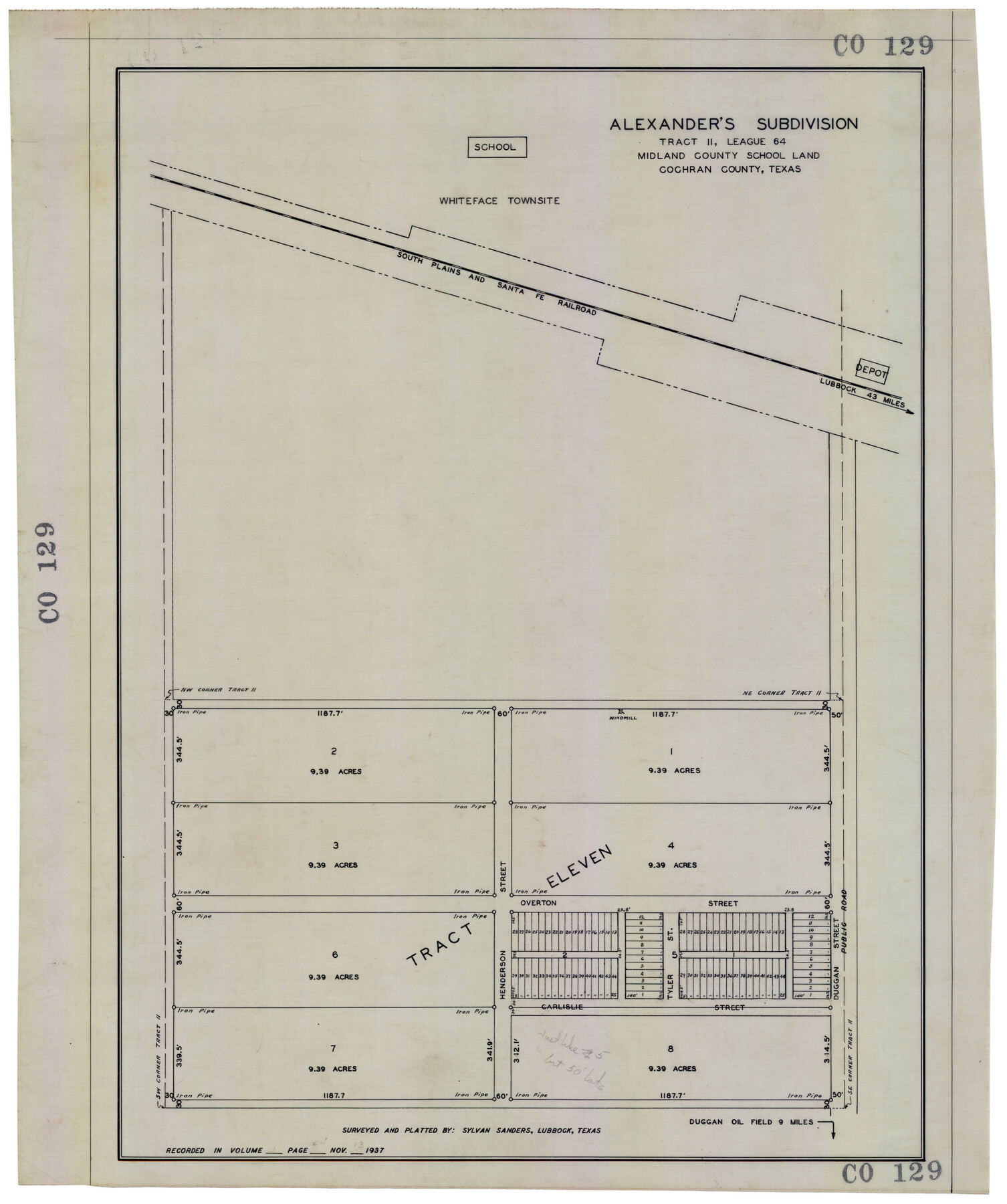
Alexander's Subdivision Tract 2, League 64 Midland County School Land, Cochran County, Texas
CO129
-
Map/Doc
92518
-
Collection
Twichell Survey Records
-
Object Dates
11/13/1937 (Creation Date)
-
People and Organizations
Sylvan Sanders (Surveyor/Engineer)
-
Counties
Cochran
-
Height x Width
19.1 x 22.7 inches
48.5 x 57.7 cm
Part of: Twichell Survey Records
Yoakum County

Print $20.00
- Digital $50.00
Yoakum County
1938
Size 24.9 x 24.6 inches
Map/Doc 92446
South Part Brewster Co.

Print $40.00
- Digital $50.00
South Part Brewster Co.
Size 48.7 x 32.8 inches
Map/Doc 92468
[PSL Blocks C31-C39]
![90790, [PSL Blocks C31-C39], Twichell Survey Records](https://historictexasmaps.com/wmedia_w700/maps/90790-1.tif.jpg)
Print $20.00
- Digital $50.00
[PSL Blocks C31-C39]
Size 43.1 x 9.8 inches
Map/Doc 90790
[Gunter & Munson, Maddox Bros. & Anderson Block O]
![91946, [Gunter & Munson, Maddox Bros. & Anderson Block O], Twichell Survey Records](https://historictexasmaps.com/wmedia_w700/maps/91946-1.tif.jpg)
Print $20.00
- Digital $50.00
[Gunter & Munson, Maddox Bros. & Anderson Block O]
Size 25.8 x 40.6 inches
Map/Doc 91946
[Subdivision of Crockett County School Land Lgs. 214-217]
![90106, [Subdivision of Crockett County School Land Lgs. 214-217], Twichell Survey Records](https://historictexasmaps.com/wmedia_w700/maps/90106-1.tif.jpg)
Print $2.00
- Digital $50.00
[Subdivision of Crockett County School Land Lgs. 214-217]
Size 12.4 x 8.5 inches
Map/Doc 90106
[League 27, Montgomery County School Land, William Tubbs Survey]
![91127, [League 27, Montgomery County School Land, William Tubbs Survey], Twichell Survey Records](https://historictexasmaps.com/wmedia_w700/maps/91127-1.tif.jpg)
Print $2.00
- Digital $50.00
[League 27, Montgomery County School Land, William Tubbs Survey]
Size 11.7 x 8.9 inches
Map/Doc 91127
State Land for Sale on Mustang Island

Print $20.00
- Digital $50.00
State Land for Sale on Mustang Island
1910
Size 20.0 x 29.5 inches
Map/Doc 91493
Plat Showing Survey made for J. M. Teague, Jr. Gaines County, Texas

Print $20.00
- Digital $50.00
Plat Showing Survey made for J. M. Teague, Jr. Gaines County, Texas
1956
Size 12.7 x 18.7 inches
Map/Doc 92672
Working Sketch in Stephens County

Print $2.00
- Digital $50.00
Working Sketch in Stephens County
1919
Size 9.2 x 11.4 inches
Map/Doc 91911
[Map of resurvey of H. & G.N. RR. Co. Blk. B2]
![89941, [Map of resurvey of H. & G.N. RR. Co. Blk. B2], Twichell Survey Records](https://historictexasmaps.com/wmedia_w700/maps/89941-1.tif.jpg)
Print $20.00
- Digital $50.00
[Map of resurvey of H. & G.N. RR. Co. Blk. B2]
1888
Size 36.6 x 37.7 inches
Map/Doc 89941
Renderbrook Ranch, Mitchell, Sterling & Coke Counties, Texas Owned by I. L. Ellwood, Estate

Print $40.00
- Digital $50.00
Renderbrook Ranch, Mitchell, Sterling & Coke Counties, Texas Owned by I. L. Ellwood, Estate
Size 50.1 x 40.0 inches
Map/Doc 89873
Adrian Heights Adition (sic) to Adrian Located in Section 16, Block K11

Print $2.00
- Digital $50.00
Adrian Heights Adition (sic) to Adrian Located in Section 16, Block K11
Size 15.6 x 7.7 inches
Map/Doc 92096
You may also like
Calhoun County Sketch File 10

Print $11.00
- Digital $50.00
Calhoun County Sketch File 10
1956
Size 14.3 x 8.8 inches
Map/Doc 35940
University Lands Blocks 38 to 57, Crockett-Reagan-Irion-Schleicher-Counties

Print $40.00
- Digital $50.00
University Lands Blocks 38 to 57, Crockett-Reagan-Irion-Schleicher-Counties
Size 35.1 x 53.6 inches
Map/Doc 62945
Falls County Sketch File 22

Print $10.00
- Digital $50.00
Falls County Sketch File 22
1921
Size 8.3 x 5.4 inches
Map/Doc 22423
Polk County Rolled Sketch TMS

Print $40.00
- Digital $50.00
Polk County Rolled Sketch TMS
1937
Size 35.7 x 56.5 inches
Map/Doc 9756
Map of Texas and the country adjacent

Print $20.00
- Digital $50.00
Map of Texas and the country adjacent
1844
Size 18.3 x 26.5 inches
Map/Doc 73052
Angelina County, Nacogdoches District

Print $20.00
- Digital $50.00
Angelina County, Nacogdoches District
1882
Size 20.0 x 27.6 inches
Map/Doc 3234
Childress County Sketch File 2a

Print $20.00
- Digital $50.00
Childress County Sketch File 2a
Size 18.3 x 34.8 inches
Map/Doc 11077
General Highway Map, Jim Wells County, Texas

Print $20.00
General Highway Map, Jim Wells County, Texas
1940
Size 18.4 x 24.8 inches
Map/Doc 79148
Brewster County Rolled Sketch 81

Print $20.00
- Digital $50.00
Brewster County Rolled Sketch 81
1945
Size 30.8 x 33.9 inches
Map/Doc 8494
Walker County

Print $20.00
- Digital $50.00
Walker County
1944
Size 40.4 x 34.4 inches
Map/Doc 77448
Martin County Working Sketch 7

Print $20.00
- Digital $50.00
Martin County Working Sketch 7
1971
Size 43.0 x 31.3 inches
Map/Doc 70825
Kent County Boundary File 5

Print $6.00
- Digital $50.00
Kent County Boundary File 5
Size 8.6 x 8.6 inches
Map/Doc 55865