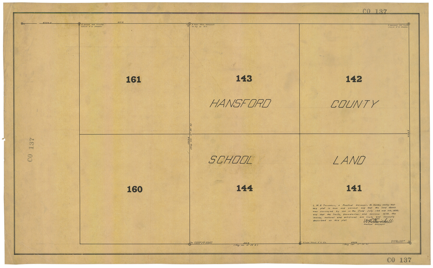
Hansford County School Land
CO137
-
Map/Doc
92512
-
Collection
Twichell Survey Records
-
Object Dates
7/11/1892 (Creation Date)
-
People and Organizations
W.D. Twichell (Surveyor/Engineer)
-
Counties
Cochran
-
Height x Width
33.3 x 20.7 inches
84.6 x 52.6 cm
Part of: Twichell Survey Records
[Palmer, Bailey, Lamb, and Cochran Counties]
![92474, [Palmer, Bailey, Lamb, and Cochran Counties], Twichell Survey Records](https://historictexasmaps.com/wmedia_w700/maps/92474-1.tif.jpg)
Print $20.00
- Digital $50.00
[Palmer, Bailey, Lamb, and Cochran Counties]
Size 15.3 x 19.3 inches
Map/Doc 92474
Sketch Showing Original Corners and Connections Affecting Blocks T1, T2, and T3 in Lamb & Castro Counties

Print $20.00
- Digital $50.00
Sketch Showing Original Corners and Connections Affecting Blocks T1, T2, and T3 in Lamb & Castro Counties
Size 26.5 x 46.0 inches
Map/Doc 90405
[Blocks C-25, C-26, C-27, and 29]
![91320, [Blocks C-25, C-26, C-27, and 29], Twichell Survey Records](https://historictexasmaps.com/wmedia_w700/maps/91320-1.tif.jpg)
Print $20.00
- Digital $50.00
[Blocks C-25, C-26, C-27, and 29]
Size 23.4 x 27.2 inches
Map/Doc 91320
Ochiltree County School Land League Number 204

Print $20.00
- Digital $50.00
Ochiltree County School Land League Number 204
1926
Size 20.8 x 13.7 inches
Map/Doc 92473
[Northwest Garza County around John Walker and Thomas Hughes surveys]
![90849, [Northwest Garza County around John Walker and Thomas Hughes surveys], Twichell Survey Records](https://historictexasmaps.com/wmedia_w700/maps/90849-2.tif.jpg)
Print $20.00
- Digital $50.00
[Northwest Garza County around John Walker and Thomas Hughes surveys]
1913
Size 27.5 x 14.5 inches
Map/Doc 90849

[Sketch of area just south of Levi Pruitt survey]
![91854, [Sketch of area just south of Levi Pruitt survey], Twichell Survey Records](https://historictexasmaps.com/wmedia_w700/maps/91854-1.tif.jpg)
Print $20.00
- Digital $50.00
[Sketch of area just south of Levi Pruitt survey]
Size 24.9 x 18.6 inches
Map/Doc 91854
[Blocks 44, 6T, 2G, and Vicinity]
![91519, [Blocks 44, 6T, 2G, and Vicinity], Twichell Survey Records](https://historictexasmaps.com/wmedia_w700/maps/91519-1.tif.jpg)
Print $20.00
- Digital $50.00
[Blocks 44, 6T, 2G, and Vicinity]
Size 24.5 x 16.9 inches
Map/Doc 91519
General Highway Map, Lubbock County

Print $20.00
- Digital $50.00
General Highway Map, Lubbock County
1947
Size 25.1 x 18.9 inches
Map/Doc 92718
[Leagues 1, 2, 281, 282, 284, and 285]
![92563, [Leagues 1, 2, 281, 282, 284, and 285], Twichell Survey Records](https://historictexasmaps.com/wmedia_w700/maps/92563-1.tif.jpg)
Print $20.00
- Digital $50.00
[Leagues 1, 2, 281, 282, 284, and 285]
Size 23.8 x 19.3 inches
Map/Doc 92563
[West and North lines of the Panhandle]
![90576, [West and North lines of the Panhandle], Twichell Survey Records](https://historictexasmaps.com/wmedia_w700/maps/90576-1.tif.jpg)
Print $20.00
- Digital $50.00
[West and North lines of the Panhandle]
1885
Size 22.0 x 32.1 inches
Map/Doc 90576
[Township 3 North, Block 33]
![91226, [Township 3 North, Block 33], Twichell Survey Records](https://historictexasmaps.com/wmedia_w700/maps/91226-1.tif.jpg)
Print $20.00
- Digital $50.00
[Township 3 North, Block 33]
Size 15.0 x 18.0 inches
Map/Doc 91226
You may also like
Sectional Map of Pecos County, Texas

Print $20.00
- Digital $50.00
Sectional Map of Pecos County, Texas
1927
Size 36.5 x 46.4 inches
Map/Doc 89878
Dallam County Rolled Sketch 7

Print $20.00
- Digital $50.00
Dallam County Rolled Sketch 7
Size 15.4 x 18.6 inches
Map/Doc 5685
Flight Mission No. DQN-7K, Frame 5, Calhoun County

Print $20.00
- Digital $50.00
Flight Mission No. DQN-7K, Frame 5, Calhoun County
1953
Size 18.5 x 19.1 inches
Map/Doc 84456
Jackson County Working Sketch 6

Print $20.00
- Digital $50.00
Jackson County Working Sketch 6
1971
Size 17.0 x 21.7 inches
Map/Doc 66454
[Surveys in Austin's Colony south of the San Antonio Road and west of the Colorado River]
![50, [Surveys in Austin's Colony south of the San Antonio Road and west of the Colorado River], General Map Collection](https://historictexasmaps.com/wmedia_w700/maps/50.tif.jpg)
Print $20.00
- Digital $50.00
[Surveys in Austin's Colony south of the San Antonio Road and west of the Colorado River]
1840
Size 16.8 x 22.2 inches
Map/Doc 50
Flight Mission No. DQO-2K, Frame 91, Galveston County

Print $20.00
- Digital $50.00
Flight Mission No. DQO-2K, Frame 91, Galveston County
1952
Size 18.8 x 22.5 inches
Map/Doc 85018
[Blocks 36 and 37, Townships 1S-5S]
![93213, [Blocks 36 and 37, Townships 1S-5S], Twichell Survey Records](https://historictexasmaps.com/wmedia_w700/maps/93213-1.tif.jpg)
Print $40.00
- Digital $50.00
[Blocks 36 and 37, Townships 1S-5S]
Size 28.9 x 83.7 inches
Map/Doc 93213
Erath County Working Sketch 29

Print $20.00
- Digital $50.00
Erath County Working Sketch 29
1970
Size 25.6 x 27.4 inches
Map/Doc 69110

Colorado County Working Sketch 2

Print $20.00
- Digital $50.00
Colorado County Working Sketch 2
1904
Size 28.8 x 30.1 inches
Map/Doc 68102
Kenedy County Rolled Sketch 14

Print $21.00
- Digital $50.00
Kenedy County Rolled Sketch 14
1951
Size 10.2 x 15.3 inches
Map/Doc 46433
Map of Starr County

Print $20.00
- Digital $50.00
Map of Starr County
1896
Size 43.7 x 26.9 inches
Map/Doc 4050