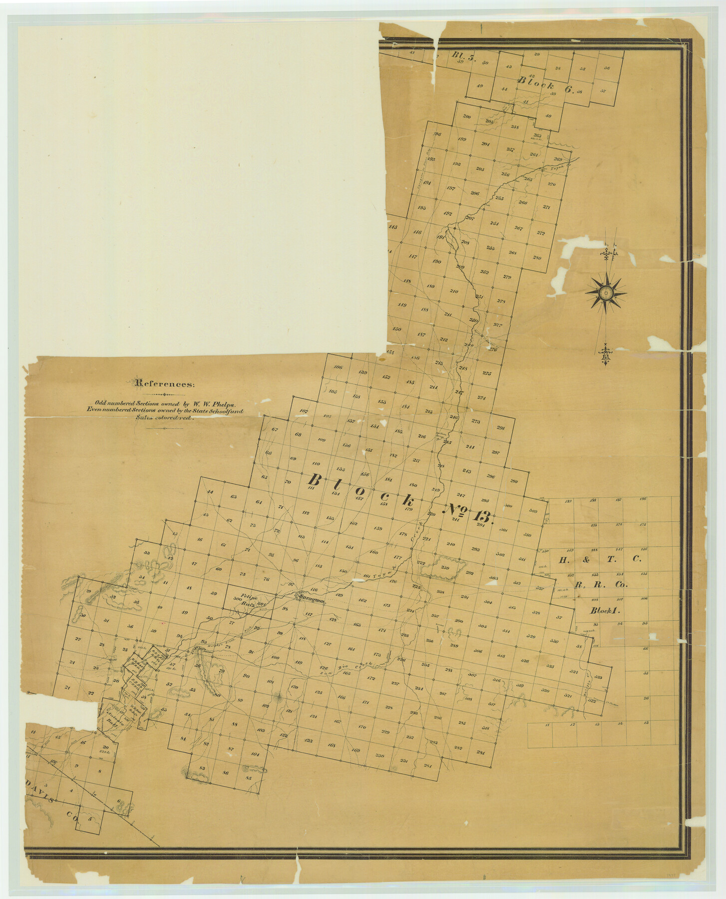
Reeves County Rolled Sketch 5
[Block 13, H. & G. N. R.R. Co.]
-
Map/Doc
7477
-
Collection
General Map Collection
-
Counties
Reeves
-
Subjects
Surveying Rolled Sketch
-
Height x Width
34.7 x 28.0 inches
88.1 x 71.1 cm
-
Medium
paper, etching/engraving/lithograph
-
Comments
Adopted in 2008 by Glen Sample Ely.
Part of: General Map Collection
Travis County Rolled Sketch 49

Print $20.00
- Digital $50.00
Travis County Rolled Sketch 49
Size 43.0 x 39.9 inches
Map/Doc 10017
Donley County Sketch File B6

Print $20.00
- Digital $50.00
Donley County Sketch File B6
1919
Size 16.5 x 14.6 inches
Map/Doc 11376
Ochiltree County Boundary File 1

Print $14.00
- Digital $50.00
Ochiltree County Boundary File 1
Size 12.7 x 8.2 inches
Map/Doc 57657
Randall County Working Sketch 2

Print $20.00
- Digital $50.00
Randall County Working Sketch 2
1980
Size 28.6 x 31.3 inches
Map/Doc 71839
Map of Jasper County

Print $20.00
- Digital $50.00
Map of Jasper County
1839
Size 40.2 x 28.8 inches
Map/Doc 78407
[Missouri, Kansas & Texas Line Map through Bastrop County]
![64030, [Missouri, Kansas & Texas Line Map through Bastrop County], General Map Collection](https://historictexasmaps.com/wmedia_w700/maps/64030.tif.jpg)
Print $40.00
- Digital $50.00
[Missouri, Kansas & Texas Line Map through Bastrop County]
1916
Size 25.5 x 74.8 inches
Map/Doc 64030
Morris County Boundary File 3

Print $6.00
- Digital $50.00
Morris County Boundary File 3
Size 10.8 x 8.1 inches
Map/Doc 57485
Map of Hill County

Print $20.00
- Digital $50.00
Map of Hill County
1862
Size 22.1 x 24.7 inches
Map/Doc 3671
Flight Mission No. DQO-2K, Frame 151, Galveston County

Print $20.00
- Digital $50.00
Flight Mission No. DQO-2K, Frame 151, Galveston County
1952
Size 18.9 x 22.6 inches
Map/Doc 85048
Real County Working Sketch 61

Print $20.00
- Digital $50.00
Real County Working Sketch 61
1964
Size 37.9 x 44.5 inches
Map/Doc 71953
Hale County Sketch File 22

Print $8.00
- Digital $50.00
Hale County Sketch File 22
1903
Size 11.1 x 8.6 inches
Map/Doc 24755
Kimble County Sketch File 41

Print $10.00
- Digital $50.00
Kimble County Sketch File 41
1994
Size 11.2 x 8.7 inches
Map/Doc 29010
You may also like
Motley County Sketch File 27 (S)

Print $6.00
- Digital $50.00
Motley County Sketch File 27 (S)
Size 14.3 x 8.3 inches
Map/Doc 32208
Montgomery County Working Sketch 57

Print $20.00
- Digital $50.00
Montgomery County Working Sketch 57
1961
Size 24.2 x 26.6 inches
Map/Doc 71164
McMullen County Rolled Sketch 21

Print $40.00
- Digital $50.00
McMullen County Rolled Sketch 21
Size 68.9 x 40.0 inches
Map/Doc 9502
Upton County Working Sketch 6

Print $20.00
- Digital $50.00
Upton County Working Sketch 6
1909
Size 17.1 x 27.0 inches
Map/Doc 69502
[Sketch for Mineral Application 26501 - Sabine River, T. A. Oldhausen]
![2837, [Sketch for Mineral Application 26501 - Sabine River, T. A. Oldhausen], General Map Collection](https://historictexasmaps.com/wmedia_w700/maps/2837.tif.jpg)
Print $20.00
- Digital $50.00
[Sketch for Mineral Application 26501 - Sabine River, T. A. Oldhausen]
1931
Size 24.1 x 36.0 inches
Map/Doc 2837
Laneer vs. Bivins, Potter County, Texas

Print $20.00
- Digital $50.00
Laneer vs. Bivins, Potter County, Texas
Size 21.7 x 19.0 inches
Map/Doc 93103
Shackelford County Boundary File 3

Print $42.00
- Digital $50.00
Shackelford County Boundary File 3
Size 11.4 x 8.7 inches
Map/Doc 58649
Taylor County Rolled Sketch 27A

Print $20.00
- Digital $50.00
Taylor County Rolled Sketch 27A
Size 30.5 x 21.4 inches
Map/Doc 7919
Republic-Era Colonies. 1841-1844

Print $20.00
Republic-Era Colonies. 1841-1844
2020
Size 22.7 x 21.7 inches
Map/Doc 96372
Galveston County Working Sketch 18

Print $20.00
- Digital $50.00
Galveston County Working Sketch 18
1982
Size 18.3 x 19.7 inches
Map/Doc 69355
Map of Drum, Oyster & Bastrop Bays & vicinity in Brazoria County showing subdivision for mineral development

Print $20.00
- Digital $50.00
Map of Drum, Oyster & Bastrop Bays & vicinity in Brazoria County showing subdivision for mineral development
Size 36.8 x 47.3 inches
Map/Doc 65808
[Sketch of part of G. & M. Block 5]
![93096, [Sketch of part of G. & M. Block 5], Twichell Survey Records](https://historictexasmaps.com/wmedia_w700/maps/93096-1.tif.jpg)
Print $2.00
- Digital $50.00
[Sketch of part of G. & M. Block 5]
Size 8.1 x 9.3 inches
Map/Doc 93096