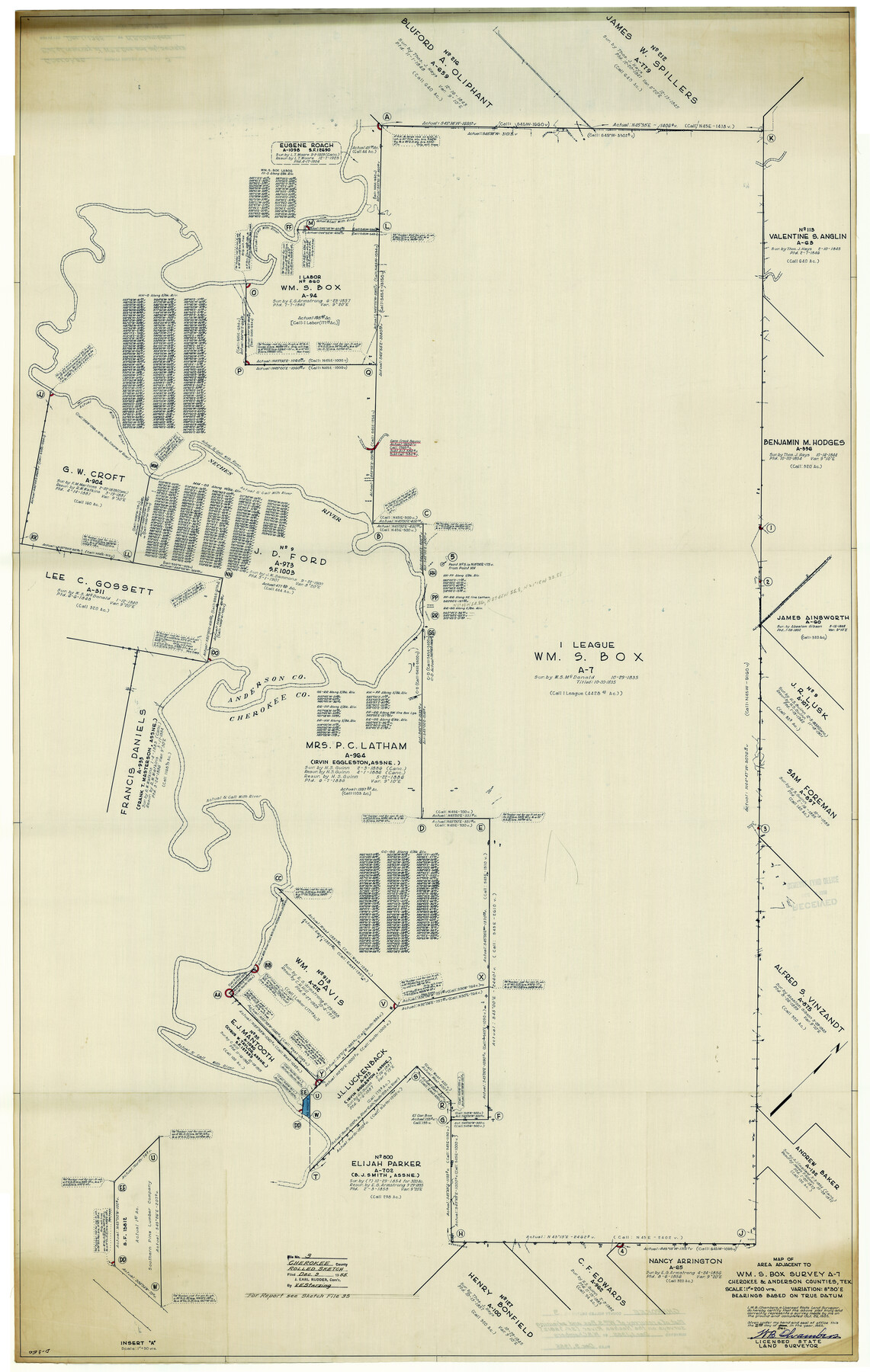
Cherokee County Rolled Sketch 3
Map of area adjacent to Wm. S. Box survey A-7 Cherokee & Anderson Counties, Tex.
-
Map/Doc
8597
-
Collection
General Map Collection
-
Object Dates
12/2/1955 (Creation Date)
12/9/1955 (File Date)
-
People and Organizations
W.B. Chambers (Surveyor/Engineer)
-
Counties
Cherokee Anderson
-
Subjects
Surveying Rolled Sketch
-
Height x Width
55.5 x 35.2 inches
141.0 x 89.4 cm
-
Medium
blueprint/diazo
-
Scale
1" = 200 varas
-
Comments
See SF-15812.
Part of: General Map Collection
Presidio County Rolled Sketch 102

Print $20.00
- Digital $50.00
Presidio County Rolled Sketch 102
1957
Size 19.3 x 13.8 inches
Map/Doc 7385
Val Verde County Rolled Sketch 67

Print $20.00
- Digital $50.00
Val Verde County Rolled Sketch 67
1958
Size 24.5 x 31.6 inches
Map/Doc 8130
[Right of Way Map, Belton Branch of the M.K.&T. RR.]
![64226, [Right of Way Map, Belton Branch of the M.K.&T. RR.], General Map Collection](https://historictexasmaps.com/wmedia_w700/maps/64226.tif.jpg)
Print $20.00
- Digital $50.00
[Right of Way Map, Belton Branch of the M.K.&T. RR.]
1896
Size 7.2 x 21.9 inches
Map/Doc 64226
Bee County Working Sketch 24

Print $20.00
- Digital $50.00
Bee County Working Sketch 24
1987
Size 36.6 x 24.0 inches
Map/Doc 67274
Terrell County Working Sketch 27

Print $20.00
- Digital $50.00
Terrell County Working Sketch 27
1944
Size 30.1 x 31.7 inches
Map/Doc 62177
Wilson County Working Sketch 13

Print $40.00
- Digital $50.00
Wilson County Working Sketch 13
1985
Size 23.9 x 53.5 inches
Map/Doc 72593
Wichita County Sketch File 24

Print $20.00
- Digital $50.00
Wichita County Sketch File 24
1919
Size 17.3 x 24.0 inches
Map/Doc 12684
Crosby County

Print $20.00
- Digital $50.00
Crosby County
1927
Size 41.1 x 36.7 inches
Map/Doc 73123
Maps of Gulf Intracoastal Waterway, Texas - Sabine River to the Rio Grande and connecting waterways including ship channels

Print $20.00
- Digital $50.00
Maps of Gulf Intracoastal Waterway, Texas - Sabine River to the Rio Grande and connecting waterways including ship channels
1966
Size 14.5 x 22.2 inches
Map/Doc 61940
Galveston County Rolled Sketch DB

Print $20.00
- Digital $50.00
Galveston County Rolled Sketch DB
Size 37.0 x 47.5 inches
Map/Doc 9854
Henderson County Working Sketch 31

Print $20.00
- Digital $50.00
Henderson County Working Sketch 31
1962
Size 38.7 x 39.6 inches
Map/Doc 66164
Travis County Rolled Sketch 16

Print $20.00
- Digital $50.00
Travis County Rolled Sketch 16
1940
Size 21.0 x 18.4 inches
Map/Doc 8018
You may also like
Duval County Working Sketch 2

Print $20.00
- Digital $50.00
Duval County Working Sketch 2
1919
Size 16.4 x 15.0 inches
Map/Doc 76443
Guide map of the Great Texas Cattle Trail from Red River crossing to the Old Reliable Kansas Pacific Railway

Print $20.00
- Digital $50.00
Guide map of the Great Texas Cattle Trail from Red River crossing to the Old Reliable Kansas Pacific Railway
1873
Size 23.4 x 17.6 inches
Map/Doc 93938
Dimmit County Boundary File 7

Print $14.00
- Digital $50.00
Dimmit County Boundary File 7
Size 12.8 x 8.4 inches
Map/Doc 52590
Sutton County Sketch File 23

Print $30.00
- Digital $50.00
Sutton County Sketch File 23
1918
Size 14.2 x 8.5 inches
Map/Doc 37461
Webb County Sketch File 11b-1

Print $20.00
- Digital $50.00
Webb County Sketch File 11b-1
1880
Size 21.7 x 19.3 inches
Map/Doc 12627
Chambers County Sketch File 39

Print $52.00
- Digital $50.00
Chambers County Sketch File 39
Size 11.0 x 6.6 inches
Map/Doc 17652
Lubbock County Sketch

Print $20.00
- Digital $50.00
Lubbock County Sketch
1945
Size 18.3 x 29.6 inches
Map/Doc 92829
Flight Mission No. DQO-7K, Frame 105, Galveston County

Print $20.00
- Digital $50.00
Flight Mission No. DQO-7K, Frame 105, Galveston County
1952
Size 18.4 x 21.8 inches
Map/Doc 85120
Flight Mission No. DQO-1K, Frame 21, Galveston County

Print $20.00
- Digital $50.00
Flight Mission No. DQO-1K, Frame 21, Galveston County
1952
Size 18.8 x 22.6 inches
Map/Doc 84980
Lipscomb County Boundary File 8

Print $4.00
- Digital $50.00
Lipscomb County Boundary File 8
Size 11.1 x 8.6 inches
Map/Doc 56333
Cameron County Rolled Sketch 20D

Print $20.00
- Digital $50.00
Cameron County Rolled Sketch 20D
Size 13.7 x 12.1 inches
Map/Doc 5476
Matagorda County Sketch File 11

Print $6.00
- Digital $50.00
Matagorda County Sketch File 11
1885
Size 9.7 x 6.2 inches
Map/Doc 30768