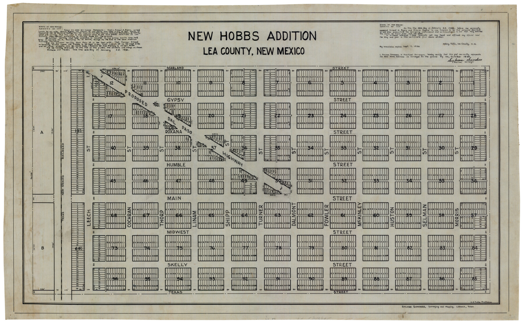
New Hobbs Addition Lea County, New Mexico
-
Map/Doc
92425
-
Collection
Twichell Survey Records
-
Object Dates
1/15/1930 (Creation Date)
-
People and Organizations
Sylvan Sanders (Surveyor/Engineer)
C.A. Tubbs (Draftsman)
-
Counties
Lea [New Mexico]
-
Height x Width
30.6 x 18.9 inches
77.7 x 48.0 cm
Part of: Twichell Survey Records
[A. & B. Block A and Block M-15]
![91930, [A. & B. Block A and Block M-15], Twichell Survey Records](https://historictexasmaps.com/wmedia_w700/maps/91930-1.tif.jpg)
Print $20.00
- Digital $50.00
[A. & B. Block A and Block M-15]
Size 37.3 x 13.3 inches
Map/Doc 91930
Sketch in Cochran County, Texas

Print $20.00
- Digital $50.00
Sketch in Cochran County, Texas
1949
Size 21.8 x 21.0 inches
Map/Doc 92495
Sketch Showing Division Fence Shelton- Matador, Oldham County

Print $20.00
- Digital $50.00
Sketch Showing Division Fence Shelton- Matador, Oldham County
Size 21.8 x 24.5 inches
Map/Doc 91486
[Strip map showing T. & P. Connecting line from northwest corner Sec. 3, Blk. 33 T5N to northwest corner Sec. 6, Blk. 34 T5N]
![93174, [Strip map showing T. & P. Connecting line from northwest corner Sec. 3, Blk. 33 T5N to northwest corner Sec. 6, Blk. 34 T5N], Twichell Survey Records](https://historictexasmaps.com/wmedia_w700/maps/93174-1.tif.jpg)
Print $40.00
- Digital $50.00
[Strip map showing T. & P. Connecting line from northwest corner Sec. 3, Blk. 33 T5N to northwest corner Sec. 6, Blk. 34 T5N]
1907
Size 7.3 x 77.5 inches
Map/Doc 93174
Map of Adrian, the New Town in the Panhandle, Oldham County, Texas (verso - Adrian promotional text)

Print $20.00
- Digital $50.00
Map of Adrian, the New Town in the Panhandle, Oldham County, Texas (verso - Adrian promotional text)
Size 26.0 x 21.5 inches
Map/Doc 92136
E. B. Shipp Irrigated Farm East Part Section 32, Block JS

Print $3.00
- Digital $50.00
E. B. Shipp Irrigated Farm East Part Section 32, Block JS
Size 9.3 x 16.7 inches
Map/Doc 92298

[Subdivision of Crockett County School Land Lgs. 214-217]
![90106, [Subdivision of Crockett County School Land Lgs. 214-217], Twichell Survey Records](https://historictexasmaps.com/wmedia_w700/maps/90106-1.tif.jpg)
Print $2.00
- Digital $50.00
[Subdivision of Crockett County School Land Lgs. 214-217]
Size 12.4 x 8.5 inches
Map/Doc 90106
[Leagues 7, 8, 9, and 10]
![92218, [Leagues 7, 8, 9, and 10], Twichell Survey Records](https://historictexasmaps.com/wmedia_w700/maps/92218-1.tif.jpg)
Print $20.00
- Digital $50.00
[Leagues 7, 8, 9, and 10]
1943
Size 20.0 x 13.4 inches
Map/Doc 92218
[Leagues 11 and 22]
![91111, [Leagues 11 and 22], Twichell Survey Records](https://historictexasmaps.com/wmedia_w700/maps/91111-1.tif.jpg)
Print $20.00
- Digital $50.00
[Leagues 11 and 22]
1925
Size 14.0 x 13.6 inches
Map/Doc 91111
Sketch from Dawson, Martin and Gaines Co's. (a part of Andrews Co. added)

Print $40.00
- Digital $50.00
Sketch from Dawson, Martin and Gaines Co's. (a part of Andrews Co. added)
1900
Size 45.0 x 50.6 inches
Map/Doc 89781
[Surveys around the Martha Barker survey]
![90236, [Surveys around the Martha Barker survey], Twichell Survey Records](https://historictexasmaps.com/wmedia_w700/maps/90236-1.tif.jpg)
Print $20.00
- Digital $50.00
[Surveys around the Martha Barker survey]
Size 24.5 x 18.1 inches
Map/Doc 90236
You may also like
Schleicher County Working Sketch 1

Print $20.00
- Digital $50.00
Schleicher County Working Sketch 1
1902
Size 14.8 x 17.4 inches
Map/Doc 63803
Oldham County Sketch File 10

Print $8.00
- Digital $50.00
Oldham County Sketch File 10
Size 12.7 x 8.3 inches
Map/Doc 33243
Garza County Sketch File G-1

Print $20.00
- Digital $50.00
Garza County Sketch File G-1
1904
Size 20.4 x 20.6 inches
Map/Doc 11554
Dallas County

Print $20.00
- Digital $50.00
Dallas County
1942
Size 45.1 x 37.1 inches
Map/Doc 77258
Tom Green County Sketch File 80

Print $20.00
- Digital $50.00
Tom Green County Sketch File 80
1962
Size 20.6 x 35.6 inches
Map/Doc 12452
Flight Mission No. DCL-6C, Frame 121, Kenedy County

Print $20.00
- Digital $50.00
Flight Mission No. DCL-6C, Frame 121, Kenedy County
1943
Size 18.6 x 22.4 inches
Map/Doc 85951
Hardeman County Working Sketch 9

Print $20.00
- Digital $50.00
Hardeman County Working Sketch 9
1953
Size 44.4 x 27.2 inches
Map/Doc 63390
Presidio County Rolled Sketch 131A

Print $20.00
- Digital $50.00
Presidio County Rolled Sketch 131A
1975
Size 30.5 x 24.9 inches
Map/Doc 10706
Flight Mission No. DQO-1K, Frame 117, Galveston County

Print $20.00
- Digital $50.00
Flight Mission No. DQO-1K, Frame 117, Galveston County
1952
Size 18.9 x 22.5 inches
Map/Doc 84995
[Garza County School Land and Vicinity]
![91294, [Garza County School Land and Vicinity], Twichell Survey Records](https://historictexasmaps.com/wmedia_w700/maps/91294-1.tif.jpg)
Print $3.00
- Digital $50.00
[Garza County School Land and Vicinity]
Size 13.4 x 11.9 inches
Map/Doc 91294
Fayette County Working Sketch 2

Print $20.00
- Digital $50.00
Fayette County Working Sketch 2
1979
Size 40.6 x 37.8 inches
Map/Doc 69166
Topographic Map, Low Rent Housing Project Texas 18-1, Housing Authority of the City of Lubbock (Plan No. 2)

Print $20.00
- Digital $50.00
Topographic Map, Low Rent Housing Project Texas 18-1, Housing Authority of the City of Lubbock (Plan No. 2)
1941
Size 42.4 x 27.2 inches
Map/Doc 92757