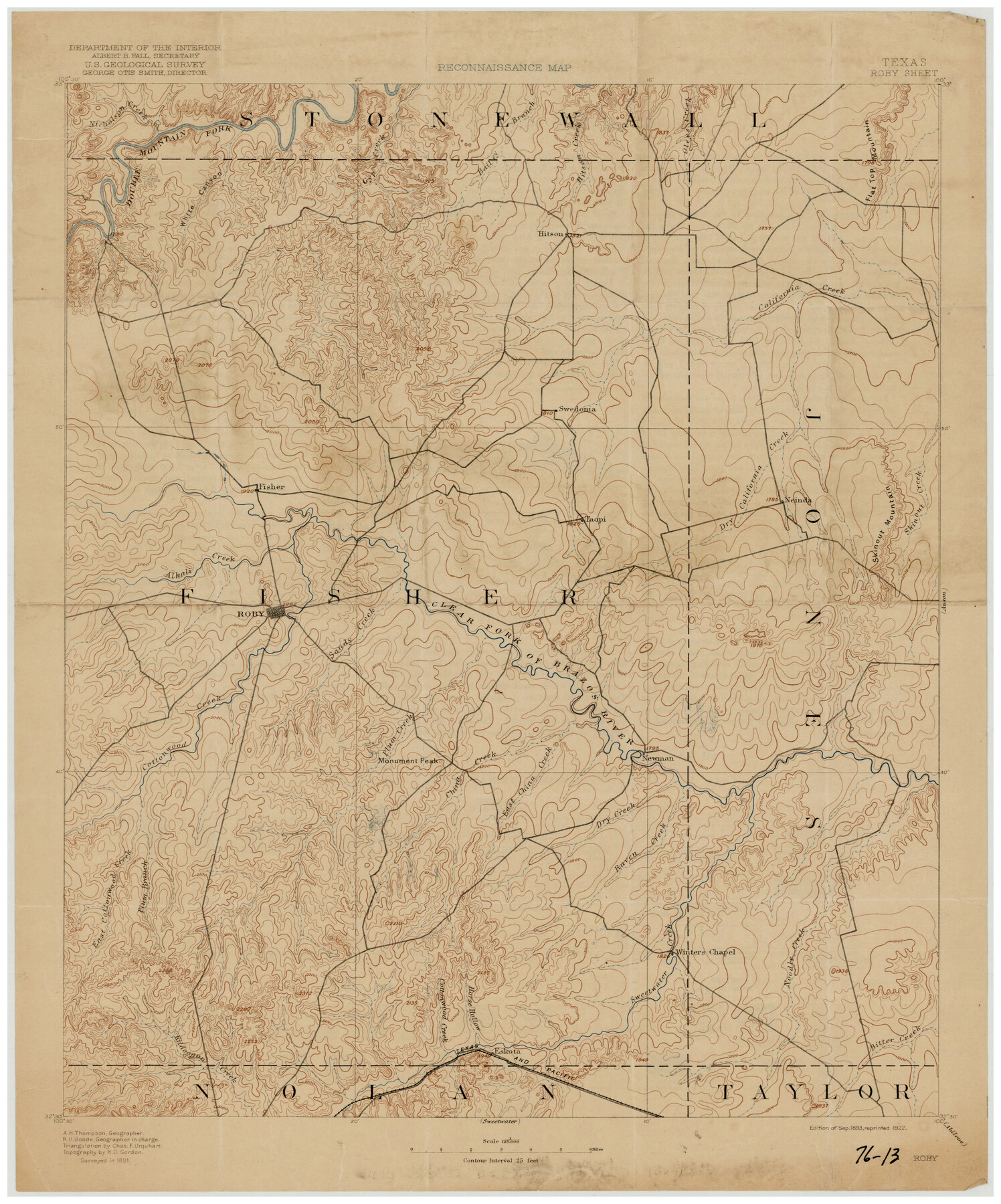
Reconnaissance Map, Roby Sheet
76-13
-
Map/Doc
90869
-
Collection
Twichell Survey Records
-
Object Dates
9/1893 (Creation Date)
-
People and Organizations
U. S. Geological Survey (Publisher)
-
Counties
Fisher Stonewall Jones Taylor
-
Height x Width
17.0 x 20.8 inches
43.2 x 52.8 cm
Part of: Twichell Survey Records
[Sketch of part of G. & M. Block 5, G. & M. Block 4, Block M19 and Block 21W]
![93113, [Sketch of part of G. & M. Block 5, G. & M. Block 4, Block M19 and Block 21W], Twichell Survey Records](https://historictexasmaps.com/wmedia_w700/maps/93113-1.tif.jpg)
Print $20.00
- Digital $50.00
[Sketch of part of G. & M. Block 5, G. & M. Block 4, Block M19 and Block 21W]
Size 22.0 x 17.0 inches
Map/Doc 93113
[Sketch Between Hemphill County and Oklahoma]
![89635, [Sketch Between Hemphill County and Oklahoma], Twichell Survey Records](https://historictexasmaps.com/wmedia_w700/maps/89635-1.tif.jpg)
Print $40.00
- Digital $50.00
[Sketch Between Hemphill County and Oklahoma]
Size 62.0 x 8.0 inches
Map/Doc 89635
Part of Garza, Crosby, Lynn, and Lubbock Counties

Print $20.00
- Digital $50.00
Part of Garza, Crosby, Lynn, and Lubbock Counties
1912
Size 24.7 x 20.4 inches
Map/Doc 91324
[H. & G. N. Block 1]
![90946, [H. & G. N. Block 1], Twichell Survey Records](https://historictexasmaps.com/wmedia_w700/maps/90946-1.tif.jpg)
Print $20.00
- Digital $50.00
[H. & G. N. Block 1]
1873
Size 17.7 x 14.5 inches
Map/Doc 90946
Sketch Showing Original Corners and Connections Affecting Blocks T1, T2, and T3 in Lamb and Castro Counties, Texas

Print $20.00
- Digital $50.00
Sketch Showing Original Corners and Connections Affecting Blocks T1, T2, and T3 in Lamb and Castro Counties, Texas
Size 17.7 x 30.6 inches
Map/Doc 92199
[Block 1 Showing County Seat]
![92951, [Block 1 Showing County Seat], Twichell Survey Records](https://historictexasmaps.com/wmedia_w700/maps/92951-1.tif.jpg)
Print $20.00
- Digital $50.00
[Block 1 Showing County Seat]
Size 20.8 x 12.3 inches
Map/Doc 92951
Sketch Showing Lands Southeast of Creek Outside of H. C. Sisco's Area, Exhibit H

Print $20.00
- Digital $50.00
Sketch Showing Lands Southeast of Creek Outside of H. C. Sisco's Area, Exhibit H
Size 20.0 x 24.5 inches
Map/Doc 91373
[Mary Fury and B. H. Epperson surveys]
![93066, [Mary Fury and B. H. Epperson surveys], Twichell Survey Records](https://historictexasmaps.com/wmedia_w700/maps/93066-1.tif.jpg)
Print $3.00
- Digital $50.00
[Mary Fury and B. H. Epperson surveys]
1919
Size 10.6 x 14.6 inches
Map/Doc 93066
[Sketch of part of Blks. B5, 6, 2Z, M6, M8, M11 and M15]
![89644, [Sketch of part of Blks. B5, 6, 2Z, M6, M8, M11 and M15], Twichell Survey Records](https://historictexasmaps.com/wmedia_w700/maps/89644-1.tif.jpg)
Print $40.00
- Digital $50.00
[Sketch of part of Blks. B5, 6, 2Z, M6, M8, M11 and M15]
Size 18.6 x 62.0 inches
Map/Doc 89644
Working Sketch in Pecos Co. [now Val Verde and Terrell Counties] / [Connecting Lines]
![91945, Working Sketch in Pecos Co. [now Val Verde and Terrell Counties] / [Connecting Lines], Twichell Survey Records](https://historictexasmaps.com/wmedia_w700/maps/91945-1.tif.jpg)
Print $20.00
- Digital $50.00
Working Sketch in Pecos Co. [now Val Verde and Terrell Counties] / [Connecting Lines]
Size 29.6 x 21.8 inches
Map/Doc 91945
[Block H, Block 24]
![92598, [Block H, Block 24], Twichell Survey Records](https://historictexasmaps.com/wmedia_w700/maps/92598-1.tif.jpg)
Print $20.00
- Digital $50.00
[Block H, Block 24]
Size 30.2 x 17.0 inches
Map/Doc 92598
[Caddo Lake Area]
![91389, [Caddo Lake Area], Twichell Survey Records](https://historictexasmaps.com/wmedia_w700/maps/91389-1.tif.jpg)
Print $20.00
- Digital $50.00
[Caddo Lake Area]
1918
Size 28.4 x 35.3 inches
Map/Doc 91389
You may also like
Surveys in Reeves and Culberson Counties, Texas and Pacific Railroad Company, Blocks 58, 59, 60, and 61

Print $20.00
- Digital $50.00
Surveys in Reeves and Culberson Counties, Texas and Pacific Railroad Company, Blocks 58, 59, 60, and 61
1937
Size 30.7 x 25.3 inches
Map/Doc 2250
McLennan County Boundary File 3

Print $8.00
- Digital $50.00
McLennan County Boundary File 3
Size 11.2 x 8.7 inches
Map/Doc 56963
Nueces County Rolled Sketch 116

Print $40.00
- Digital $50.00
Nueces County Rolled Sketch 116
Size 29.6 x 58.3 inches
Map/Doc 7141
United States - Gulf Coast - Galveston to Rio Grande

Print $20.00
- Digital $50.00
United States - Gulf Coast - Galveston to Rio Grande
1941
Size 27.2 x 18.2 inches
Map/Doc 72753
Fractional Township No. 7 South Range No. 21 East of the Indian Meridian, Indian Territory

Print $20.00
- Digital $50.00
Fractional Township No. 7 South Range No. 21 East of the Indian Meridian, Indian Territory
1897
Size 19.2 x 24.2 inches
Map/Doc 75237
[Sketch for Mineral Application 13436 - 13441]
![65582, [Sketch for Mineral Application 13436 - 13441], General Map Collection](https://historictexasmaps.com/wmedia_w700/maps/65582.tif.jpg)
Print $40.00
- Digital $50.00
[Sketch for Mineral Application 13436 - 13441]
1925
Size 56.8 x 42.5 inches
Map/Doc 65582
Flight Mission No. DAG-21K, Frame 116, Matagorda County

Print $20.00
- Digital $50.00
Flight Mission No. DAG-21K, Frame 116, Matagorda County
1952
Size 18.6 x 22.3 inches
Map/Doc 86439
Flight Mission No. CON-4R, Frame 200, Stonewall County

Print $20.00
- Digital $50.00
Flight Mission No. CON-4R, Frame 200, Stonewall County
1957
Size 18.2 x 22.0 inches
Map/Doc 86994
Concho County Working Sketch 15
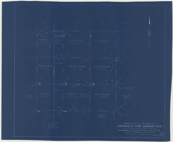
Print $20.00
- Digital $50.00
Concho County Working Sketch 15
1955
Size 25.2 x 30.8 inches
Map/Doc 68197
Sutton County Rolled Sketch 40

Print $20.00
- Digital $50.00
Sutton County Rolled Sketch 40
1930
Size 25.9 x 28.3 inches
Map/Doc 7882
The Rand McNally New Commercial Atlas Map of Texas

Print $20.00
- Digital $50.00
The Rand McNally New Commercial Atlas Map of Texas
1919
Size 28.4 x 40.2 inches
Map/Doc 95852
Crockett County Working Sketch 25

Print $20.00
- Digital $50.00
Crockett County Working Sketch 25
1921
Size 23.5 x 17.6 inches
Map/Doc 68358