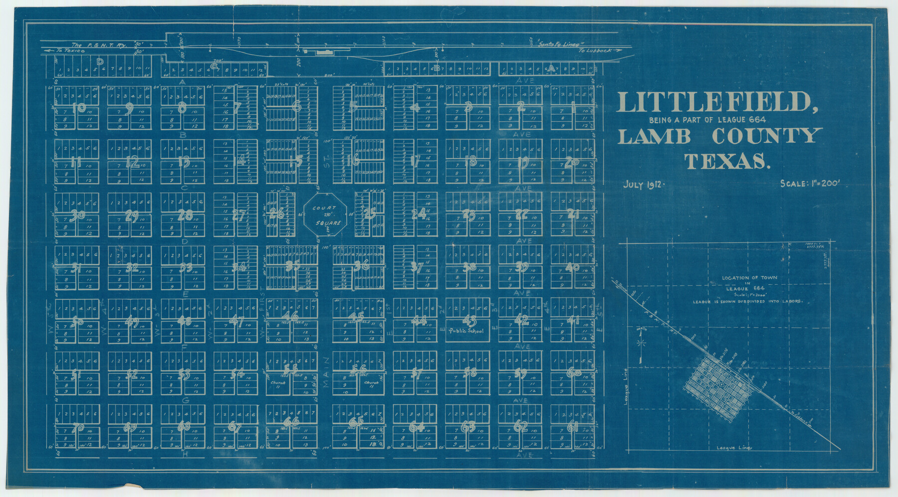
Littlefield, being a part of League 664, Lamb County, Texas
-
Map/Doc
92150
-
Collection
Twichell Survey Records
-
Object Dates
7/1912 (Creation Date)
-
Counties
Lamb
-
Height x Width
30.5 x 16.9 inches
77.5 x 42.9 cm
Part of: Twichell Survey Records
[West line of Randall County]
![91705, [West line of Randall County], Twichell Survey Records](https://historictexasmaps.com/wmedia_w700/maps/91705-1.tif.jpg)
Print $20.00
- Digital $50.00
[West line of Randall County]
Size 4.2 x 19.9 inches
Map/Doc 91705
[Part of T. & N. O. RR. Co Block 2 and area around Jasper Hays survey]
![90850, [Part of T. & N. O. RR. Co Block 2 and area around Jasper Hays survey], Twichell Survey Records](https://historictexasmaps.com/wmedia_w700/maps/90850-2.tif.jpg)
Print $20.00
- Digital $50.00
[Part of T. & N. O. RR. Co Block 2 and area around Jasper Hays survey]
1907
Size 13.3 x 28.4 inches
Map/Doc 90850
[Sections 58 through 95]
![92478, [Sections 58 through 95], Twichell Survey Records](https://historictexasmaps.com/wmedia_w700/maps/92478-1.tif.jpg)
Print $20.00
- Digital $50.00
[Sections 58 through 95]
Size 23.9 x 19.5 inches
Map/Doc 92478
Lipscomb County, Texas

Print $20.00
- Digital $50.00
Lipscomb County, Texas
Size 13.7 x 15.0 inches
Map/Doc 91304
[Pencil sketch showing area between sections 1102, 1101, 1111, and 1112 on the west and sections 3-6 on the east]
![90365, [Pencil sketch showing area between sections 1102, 1101, 1111, and 1112 on the west and sections 3-6 on the east], Twichell Survey Records](https://historictexasmaps.com/wmedia_w700/maps/90365-1.tif.jpg)
Print $2.00
- Digital $50.00
[Pencil sketch showing area between sections 1102, 1101, 1111, and 1112 on the west and sections 3-6 on the east]
Size 5.1 x 8.1 inches
Map/Doc 90365
Sketch showing north boundary line of XIT lands and conflict of enclosure with L. & H. Blum land

Print $2.00
- Digital $50.00
Sketch showing north boundary line of XIT lands and conflict of enclosure with L. & H. Blum land
1906
Size 14.4 x 7.8 inches
Map/Doc 90519
R. C. Johnson Farm NW Quarter, Section 3

Print $20.00
- Digital $50.00
R. C. Johnson Farm NW Quarter, Section 3
Size 12.3 x 14.9 inches
Map/Doc 92405

[H. & T. C. RR. Company, Block 47, Sections 47- 52]
![91411, [H. & T. C. RR. Company, Block 47, Sections 47- 52], Twichell Survey Records](https://historictexasmaps.com/wmedia_w700/maps/91411-1.tif.jpg)
Print $2.00
- Digital $50.00
[H. & T. C. RR. Company, Block 47, Sections 47- 52]
Size 8.6 x 11.1 inches
Map/Doc 91411
[River Sections 58-62 and vicinity]
![91587, [River Sections 58-62 and vicinity], Twichell Survey Records](https://historictexasmaps.com/wmedia_w700/maps/91587-1.tif.jpg)
Print $20.00
- Digital $50.00
[River Sections 58-62 and vicinity]
Size 17.6 x 14.6 inches
Map/Doc 91587
Map of Rotan Fisher County, Texas

Print $20.00
- Digital $50.00
Map of Rotan Fisher County, Texas
1926
Size 32.2 x 36.5 inches
Map/Doc 93231
Map of the Northeast part of the Pitchfork Ranch

Print $20.00
- Digital $50.00
Map of the Northeast part of the Pitchfork Ranch
1916
Size 23.2 x 23.6 inches
Map/Doc 91046
You may also like
Webb County Working Sketch 4

Print $20.00
- Digital $50.00
Webb County Working Sketch 4
1907
Size 45.6 x 42.5 inches
Map/Doc 72369
Bowie County Sketch File 8c

Print $32.00
- Digital $50.00
Bowie County Sketch File 8c
1928
Size 8.1 x 5.3 inches
Map/Doc 14878
Township 13 South Ranges 14 and 15 West, South Western District, Louisiana

Print $20.00
- Digital $50.00
Township 13 South Ranges 14 and 15 West, South Western District, Louisiana
1838
Size 19.6 x 24.8 inches
Map/Doc 65857
Crane County Working Sketch 31

Print $20.00
- Digital $50.00
Crane County Working Sketch 31
1982
Size 34.3 x 37.7 inches
Map/Doc 68308
The Republic County of Shelby. January 28, 1839

Print $20.00
The Republic County of Shelby. January 28, 1839
2020
Size 21.1 x 21.7 inches
Map/Doc 96281
Flight Mission No. CGI-3N, Frame 167, Cameron County

Print $20.00
- Digital $50.00
Flight Mission No. CGI-3N, Frame 167, Cameron County
1954
Size 18.6 x 22.4 inches
Map/Doc 84631
Terrell County Rolled Sketch 19

Print $20.00
- Digital $50.00
Terrell County Rolled Sketch 19
1884
Size 22.4 x 26.9 inches
Map/Doc 7927
Uvalde County Sketch File 14

Print $6.00
- Digital $50.00
Uvalde County Sketch File 14
1849
Size 8.5 x 11.0 inches
Map/Doc 12529
Harrison County Sketch File 14

Print $32.00
- Digital $50.00
Harrison County Sketch File 14
1880
Size 11.2 x 8.8 inches
Map/Doc 26053
Edwards County Rolled Sketch 22

Print $20.00
- Digital $50.00
Edwards County Rolled Sketch 22
1951
Size 46.0 x 25.4 inches
Map/Doc 8845
Platts [sic] of S. C. Robertson Surveys
![105, Platts [sic] of S. C. Robertson Surveys, General Map Collection](https://historictexasmaps.com/wmedia_w700/maps/105.tif.jpg)
Print $20.00
- Digital $50.00
Platts [sic] of S. C. Robertson Surveys
1841
Size 13.6 x 15.7 inches
Map/Doc 105
Sectional Map of Martin County, Texas

Print $3.00
- Digital $50.00
Sectional Map of Martin County, Texas
Size 9.6 x 12.1 inches
Map/Doc 91293