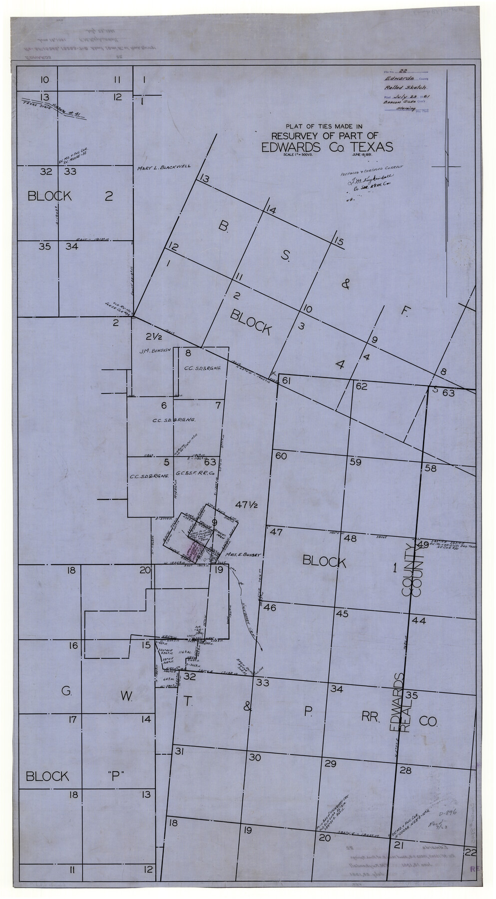
Edwards County Rolled Sketch 22
Plat of ties made in resurvey of part of Edwards Co., Texas
-
Map/Doc
8845
-
Collection
General Map Collection
-
Object Dates
1951/6/18 (Creation Date)
1951/7/23 (File Date)
-
People and Organizations
F.M. Kuykendall (Surveyor/Engineer)
-
Counties
Edwards
-
Subjects
Surveying Rolled Sketch
-
Height x Width
46.0 x 25.4 inches
116.8 x 64.5 cm
-
Medium
linen, manuscript
-
Scale
1" = 500 varas
Part of: General Map Collection
[Plat of Trinity River w/ Midstream Profile in Liberty County by US Government 1899]
![65335, [Plat of Trinity River w/ Midstream Profile in Liberty County by US Government 1899], General Map Collection](https://historictexasmaps.com/wmedia_w700/maps/65335.tif.jpg)
Print $20.00
- Digital $50.00
[Plat of Trinity River w/ Midstream Profile in Liberty County by US Government 1899]
1899
Size 11.5 x 18.3 inches
Map/Doc 65335
Kent County Working Sketch 5

Print $40.00
- Digital $50.00
Kent County Working Sketch 5
1950
Size 36.7 x 50.1 inches
Map/Doc 70012
Map of Comal County

Print $20.00
- Digital $50.00
Map of Comal County
1862
Size 18.6 x 22.0 inches
Map/Doc 3429
Terrell County Sketch File 15

Print $20.00
- Digital $50.00
Terrell County Sketch File 15
1890
Size 16.0 x 21.6 inches
Map/Doc 12421
Hardin County Working Sketch 29

Print $20.00
- Digital $50.00
Hardin County Working Sketch 29
1958
Size 36.7 x 22.1 inches
Map/Doc 63427
Brazoria County Rolled Sketch 19

Print $20.00
- Digital $50.00
Brazoria County Rolled Sketch 19
Size 16.9 x 19.0 inches
Map/Doc 5166
Flight Mission No. DAG-24K, Frame 137, Matagorda County

Print $20.00
- Digital $50.00
Flight Mission No. DAG-24K, Frame 137, Matagorda County
1953
Size 18.5 x 22.2 inches
Map/Doc 86555
Rusk County Working Sketch 28

Print $20.00
- Digital $50.00
Rusk County Working Sketch 28
1934
Size 24.2 x 18.3 inches
Map/Doc 63664
Flight Mission No. BRE-3P, Frame 38, Nueces County

Print $20.00
- Digital $50.00
Flight Mission No. BRE-3P, Frame 38, Nueces County
1956
Size 18.5 x 22.4 inches
Map/Doc 86816
Hutchinson County Working Sketch 15

Print $20.00
- Digital $50.00
Hutchinson County Working Sketch 15
1949
Size 26.4 x 15.4 inches
Map/Doc 66373
Austin's colony 1821-1836: In commemoration of the two hundredth birthday of Stephen F. Austin

Print $20.00
- Digital $50.00
Austin's colony 1821-1836: In commemoration of the two hundredth birthday of Stephen F. Austin
1993
Size 24.6 x 34.5 inches
Map/Doc 1675
Llano County Boundary File 1

Print $10.00
- Digital $50.00
Llano County Boundary File 1
Size 8.7 x 4.0 inches
Map/Doc 56425
You may also like
Sketch F Showing the Progress of the Survey in Section VI With a General Reconnoissance of the Western Coast of Florida

Print $20.00
- Digital $50.00
Sketch F Showing the Progress of the Survey in Section VI With a General Reconnoissance of the Western Coast of Florida
1848
Size 25.5 x 19.2 inches
Map/Doc 97216
Austin including Bergstrom AFB, Hays, Mansfield Dam, McKinney Falls State Park, Oak Hill, Rollingwood, San Leanna, Sunset Valley and West Lake Hills - also portions of Pflugerville

Austin including Bergstrom AFB, Hays, Mansfield Dam, McKinney Falls State Park, Oak Hill, Rollingwood, San Leanna, Sunset Valley and West Lake Hills - also portions of Pflugerville
Size 38.4 x 25.6 inches
Map/Doc 94375
Jeff Davis County Sketch File 35

Print $20.00
- Digital $50.00
Jeff Davis County Sketch File 35
1950
Size 20.6 x 19.2 inches
Map/Doc 11866
Matagorda County Boundary File 1b

Print $6.00
- Digital $50.00
Matagorda County Boundary File 1b
Size 14.2 x 8.5 inches
Map/Doc 56893
General Highway Map, Goliad County, Texas

Print $20.00
General Highway Map, Goliad County, Texas
1961
Size 18.2 x 24.7 inches
Map/Doc 79481
Wilbarger County Sketch File 26

Print $4.00
- Digital $50.00
Wilbarger County Sketch File 26
1885
Size 14.3 x 8.6 inches
Map/Doc 40227
Bandera County Working Sketch 36

Print $20.00
- Digital $50.00
Bandera County Working Sketch 36
1966
Size 22.5 x 29.5 inches
Map/Doc 67632
Montgomery County Working Sketch 5

Print $20.00
- Digital $50.00
Montgomery County Working Sketch 5
1932
Size 31.6 x 37.0 inches
Map/Doc 71111
[Sketch for Mineral Application 33721 - 33725 Incl. - Padre and Mustang Island]
![2873, [Sketch for Mineral Application 33721 - 33725 Incl. - Padre and Mustang Island], General Map Collection](https://historictexasmaps.com/wmedia_w700/maps/2873.tif.jpg)
Print $20.00
- Digital $50.00
[Sketch for Mineral Application 33721 - 33725 Incl. - Padre and Mustang Island]
1942
Size 26.6 x 22.7 inches
Map/Doc 2873
Mason County Rolled Sketch 7

Print $20.00
- Digital $50.00
Mason County Rolled Sketch 7
1986
Size 24.3 x 20.3 inches
Map/Doc 6679
The Republic County of Shelby. January 28, 1839

Print $20.00
The Republic County of Shelby. January 28, 1839
2020
Size 21.1 x 21.7 inches
Map/Doc 96281
Parker County Sketch File 9

Print $4.00
- Digital $50.00
Parker County Sketch File 9
Size 8.1 x 10.0 inches
Map/Doc 33538