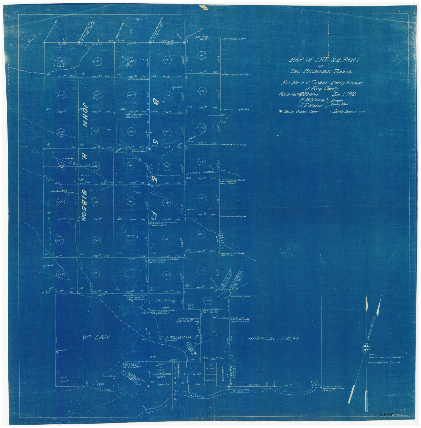
Map of the Northeast part of the Pitchfork Ranch
135-13
-
Map/Doc
91046
-
Collection
Twichell Survey Records
-
Object Dates
1/1/1916 (Creation Date)
-
People and Organizations
F.M. Maddox (Surveyor/Engineer)
E.F. Maddox (Draftsman)
-
Counties
King
-
Height x Width
23.2 x 23.6 inches
58.9 x 59.9 cm
Part of: Twichell Survey Records
[Sutton, Hale & Ector Co. School Land]
![90102, [Sutton, Hale & Ector Co. School Land], Twichell Survey Records](https://historictexasmaps.com/wmedia_w700/maps/90102-1.tif.jpg)
Print $3.00
- Digital $50.00
[Sutton, Hale & Ector Co. School Land]
Size 9.7 x 16.8 inches
Map/Doc 90102
[B. S. & F. Blocks 1 and 6, A. B. & M. Block 2 and surrounding surveys and blocks]
![91785, [B. S. & F. Blocks 1 and 6, A. B. & M. Block 2 and surrounding surveys and blocks], Twichell Survey Records](https://historictexasmaps.com/wmedia_w700/maps/91785-1.tif.jpg)
Print $20.00
- Digital $50.00
[B. S. & F. Blocks 1 and 6, A. B. & M. Block 2 and surrounding surveys and blocks]
Size 22.6 x 33.8 inches
Map/Doc 91785
Gulf Coast Oil Fields

Print $2.00
- Digital $50.00
Gulf Coast Oil Fields
Size 12.6 x 8.1 inches
Map/Doc 90135
Jno. B. Slaughter US Ranch situated in Garza County, Texas

Print $40.00
- Digital $50.00
Jno. B. Slaughter US Ranch situated in Garza County, Texas
Size 34.6 x 49.2 inches
Map/Doc 89946
[North 1/2 of Garza County, South 1/2 of Crosby County]
![90908, [North 1/2 of Garza County, South 1/2 of Crosby County], Twichell Survey Records](https://historictexasmaps.com/wmedia_w700/maps/90908-1.tif.jpg)
Print $20.00
- Digital $50.00
[North 1/2 of Garza County, South 1/2 of Crosby County]
Size 34.7 x 31.1 inches
Map/Doc 90908
[State Capitol Lands and various county School Land Leagues]
![90508, [State Capitol Lands and various county School Land Leagues], Twichell Survey Records](https://historictexasmaps.com/wmedia_w700/maps/90508-1.tif.jpg)
Print $2.00
- Digital $50.00
[State Capitol Lands and various county School Land Leagues]
1903
Size 8.3 x 10.1 inches
Map/Doc 90508
Rhoades Heights, North Part of West Half, Section 8, Block E

Print $20.00
- Digital $50.00
Rhoades Heights, North Part of West Half, Section 8, Block E
Size 29.2 x 13.5 inches
Map/Doc 92759
Sketch Showing all that Portion of Block 24 North of Santa Fe R. R. Right-of-Way in Original Town of Lubbock

Print $20.00
- Digital $50.00
Sketch Showing all that Portion of Block 24 North of Santa Fe R. R. Right-of-Way in Original Town of Lubbock
1925
Size 26.9 x 34.4 inches
Map/Doc 92809
[Part of Eastern Texas RR. Co. Block 1]
![91921, [Part of Eastern Texas RR. Co. Block 1], Twichell Survey Records](https://historictexasmaps.com/wmedia_w700/maps/91921-1.tif.jpg)
Print $20.00
- Digital $50.00
[Part of Eastern Texas RR. Co. Block 1]
Size 23.9 x 43.1 inches
Map/Doc 91921
Borden County

Print $20.00
- Digital $50.00
Borden County
1922
Size 37.2 x 41.6 inches
Map/Doc 92456
Map of Terry County

Print $20.00
- Digital $50.00
Map of Terry County
Size 34.0 x 34.2 inches
Map/Doc 92933
[Block Z and vicinity]
![91576, [Block Z and vicinity], Twichell Survey Records](https://historictexasmaps.com/wmedia_w700/maps/91576-1.tif.jpg)
Print $20.00
- Digital $50.00
[Block Z and vicinity]
1886
Size 32.4 x 11.6 inches
Map/Doc 91576
You may also like
Rockwall County Sketch File 3

Print $6.00
Rockwall County Sketch File 3
1851
Size 17.2 x 11.6 inches
Map/Doc 35417
Denton County Sketch File 15

Print $8.00
- Digital $50.00
Denton County Sketch File 15
1857
Size 13.1 x 8.2 inches
Map/Doc 20724
Blanco County Working Sketch 29

Print $40.00
- Digital $50.00
Blanco County Working Sketch 29
1969
Size 52.4 x 33.4 inches
Map/Doc 67389
Brazoria County Sketch File 7

Print $4.00
- Digital $50.00
Brazoria County Sketch File 7
1868
Size 8.6 x 11.0 inches
Map/Doc 14932
[Nueces Bay, Mustang Island and Padre Island]
![73463, [Nueces Bay, Mustang Island and Padre Island], General Map Collection](https://historictexasmaps.com/wmedia_w700/maps/73463-1.tif.jpg)
Print $4.00
- Digital $50.00
[Nueces Bay, Mustang Island and Padre Island]
1887
Size 18.5 x 26.2 inches
Map/Doc 73463
Hudspeth County Rolled Sketch 72

Print $40.00
- Digital $50.00
Hudspeth County Rolled Sketch 72
1992
Size 36.7 x 49.0 inches
Map/Doc 9235
United States - Gulf Coast Texas - Southern part of Laguna Madre

Print $20.00
- Digital $50.00
United States - Gulf Coast Texas - Southern part of Laguna Madre
1941
Size 26.7 x 18.3 inches
Map/Doc 72944
United States - Gulf Coast Texas - Southern part of Laguna Madre

Print $20.00
- Digital $50.00
United States - Gulf Coast Texas - Southern part of Laguna Madre
1933
Size 26.8 x 18.3 inches
Map/Doc 72949
Moore County Working Sketch 6

Print $20.00
- Digital $50.00
Moore County Working Sketch 6
1921
Size 16.0 x 14.5 inches
Map/Doc 71188
Reeves County Rolled Sketch 1

Print $40.00
- Digital $50.00
Reeves County Rolled Sketch 1
Size 52.9 x 38.5 inches
Map/Doc 9844
Medina County Sketch File 13

Print $20.00
- Digital $50.00
Medina County Sketch File 13
Size 18.1 x 22.7 inches
Map/Doc 12069
Brazoria County NRC Article 33.136 Sketch 10

Print $23.00
- Digital $50.00
Brazoria County NRC Article 33.136 Sketch 10
2007
Size 25.7 x 35.7 inches
Map/Doc 87933