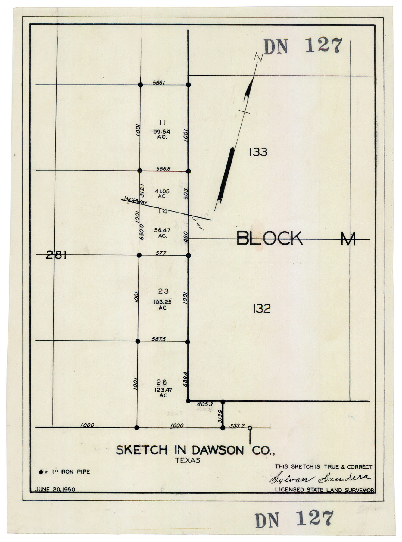
Sketch in Dawson County, Texas
DN127
-
Map/Doc
92627
-
Collection
Twichell Survey Records
-
Object Dates
6/20/1950 (Creation Date)
-
People and Organizations
Sylvan Sanders (Surveyor/Engineer)
-
Counties
Dawson
-
Height x Width
9.5 x 12.8 inches
24.1 x 32.5 cm
Part of: Twichell Survey Records
[North part of University Lands Block 20]
![91581, [North part of University Lands Block 20], Twichell Survey Records](https://historictexasmaps.com/wmedia_w700/maps/91581-1.tif.jpg)
Print $2.00
- Digital $50.00
[North part of University Lands Block 20]
Size 10.8 x 8.3 inches
Map/Doc 91581
Working Sketch in Stephens-Palo Pinto Cos.

Print $20.00
- Digital $50.00
Working Sketch in Stephens-Palo Pinto Cos.
1919
Size 21.7 x 13.2 inches
Map/Doc 91887
Thomas Kelly Subdivision in Parmer and Castro Counties, Texas

Print $20.00
- Digital $50.00
Thomas Kelly Subdivision in Parmer and Castro Counties, Texas
1906
Size 20.4 x 16.6 inches
Map/Doc 92549
Wortham & Williams' Subdivisions of the San Augustine County School Leagues situated in Lubbock Co., Texas

Print $40.00
- Digital $50.00
Wortham & Williams' Subdivisions of the San Augustine County School Leagues situated in Lubbock Co., Texas
1909
Size 38.7 x 52.1 inches
Map/Doc 89935
[Blocks M-23, M-17, M-18, H, G, and vicinity]
![91141, [Blocks M-23, M-17, M-18, H, G, and vicinity], Twichell Survey Records](https://historictexasmaps.com/wmedia_w700/maps/91141-1.tif.jpg)
Print $20.00
- Digital $50.00
[Blocks M-23, M-17, M-18, H, G, and vicinity]
1882
Size 12.9 x 12.4 inches
Map/Doc 91141
Heydrick's Ownership Map of Concho Co. Tex.

Print $20.00
- Digital $50.00
Heydrick's Ownership Map of Concho Co. Tex.
1919
Size 33.9 x 37.9 inches
Map/Doc 92616
Map of Spearman Lands

Print $20.00
- Digital $50.00
Map of Spearman Lands
Size 20.4 x 15.6 inches
Map/Doc 90834
[Southwest part of B. S. & F. Block and surveys to the south]
![90389, [Southwest part of B. S. & F. Block and surveys to the south], Twichell Survey Records](https://historictexasmaps.com/wmedia_w700/maps/90389-1.tif.jpg)
Print $3.00
- Digital $50.00
[Southwest part of B. S. & F. Block and surveys to the south]
Size 11.1 x 10.3 inches
Map/Doc 90389
Working Sketch in Stephens County

Print $20.00
- Digital $50.00
Working Sketch in Stephens County
1919
Size 15.4 x 18.6 inches
Map/Doc 91912
[Connection to Block M-6 and west Castro and Swisher]
![93041, [Connection to Block M-6 and west Castro and Swisher], Twichell Survey Records](https://historictexasmaps.com/wmedia_w700/maps/93041-1.tif.jpg)
Print $40.00
- Digital $50.00
[Connection to Block M-6 and west Castro and Swisher]
Size 60.9 x 28.3 inches
Map/Doc 93041
[Blocks M17, M18, M23, H, I, Z, and XO2]
![91245, [Blocks M17, M18, M23, H, I, Z, and XO2], Twichell Survey Records](https://historictexasmaps.com/wmedia_w700/maps/91245-1.tif.jpg)
Print $20.00
- Digital $50.00
[Blocks M17, M18, M23, H, I, Z, and XO2]
Size 34.5 x 27.2 inches
Map/Doc 91245
Working Sketch in Pecos Co. [now Val Verde and Terrell Counties] / [Connecting Lines]
![91865, Working Sketch in Pecos Co. [now Val Verde and Terrell Counties] / [Connecting Lines], Twichell Survey Records](https://historictexasmaps.com/wmedia_w700/maps/91865-1.tif.jpg)
Print $20.00
- Digital $50.00
Working Sketch in Pecos Co. [now Val Verde and Terrell Counties] / [Connecting Lines]
Size 18.6 x 24.3 inches
Map/Doc 91865
You may also like
General Highway Map, Knox County, Texas

Print $20.00
General Highway Map, Knox County, Texas
1961
Size 18.2 x 24.9 inches
Map/Doc 79560
Houston County Sketch File 4

Print $24.00
- Digital $50.00
Houston County Sketch File 4
1859
Size 12.7 x 8.3 inches
Map/Doc 26751
The Land Offices. No. 6, Washington, December 22, 1836

Print $20.00
The Land Offices. No. 6, Washington, December 22, 1836
2020
Size 16.5 x 21.7 inches
Map/Doc 96419
[Sketch for Mineral Application 33721 - 33725 Incl. - Padre and Mustang Island]
![65664, [Sketch for Mineral Application 33721 - 33725 Incl. - Padre and Mustang Island], General Map Collection](https://historictexasmaps.com/wmedia_w700/maps/65664.tif.jpg)
Print $20.00
- Digital $50.00
[Sketch for Mineral Application 33721 - 33725 Incl. - Padre and Mustang Island]
Size 42.3 x 22.6 inches
Map/Doc 65664
Kinney County Rolled Sketch 19

Print $20.00
- Digital $50.00
Kinney County Rolled Sketch 19
1978
Size 20.7 x 16.8 inches
Map/Doc 6546
Carta geográfica que comprende en su extensión mucha parte del arzobispado de México, y alguna de los obispados de Puebla, Valladolid de Michoacán, Guadalajara y Durango, confinantes entre si

Carta geográfica que comprende en su extensión mucha parte del arzobispado de México, y alguna de los obispados de Puebla, Valladolid de Michoacán, Guadalajara y Durango, confinantes entre si
1779
Size 33.9 x 22.0 inches
Map/Doc 97079
Eastland County Working Sketch Graphic Index

Print $20.00
- Digital $50.00
Eastland County Working Sketch Graphic Index
1945
Size 41.6 x 42.4 inches
Map/Doc 76529
Map of Haskell County

Print $20.00
- Digital $50.00
Map of Haskell County
1899
Size 40.1 x 35.3 inches
Map/Doc 16847
Terrell County Rolled Sketch 49

Print $20.00
- Digital $50.00
Terrell County Rolled Sketch 49
1962
Size 17.3 x 24.1 inches
Map/Doc 7951
Colton's New Map of the State of Texas Compiled from J. DeCordova's large Map

Print $20.00
Colton's New Map of the State of Texas Compiled from J. DeCordova's large Map
1858
Size 17.0 x 26.2 inches
Map/Doc 79736
Fayette County Working Sketch 5

Print $20.00
- Digital $50.00
Fayette County Working Sketch 5
1981
Size 16.2 x 14.6 inches
Map/Doc 69169
Jones County Sketch File 19

Print $56.00
- Digital $50.00
Jones County Sketch File 19
1875
Size 11.1 x 8.6 inches
Map/Doc 28516