![91820, [Block M-19], Twichell Survey Records](https://historictexasmaps.com/wmedia_w1800h1800/maps/91820-1.tif.jpg)
[Block M-19]
188-30
-
Map/Doc
91820
-
Collection
Twichell Survey Records
-
Object Dates
1907 (Creation Date)
-
Counties
Potter
-
Height x Width
32.1 x 20.6 inches
81.5 x 52.3 cm
Part of: Twichell Survey Records
[Block 1 and vicinity]
![90703, [Block 1 and vicinity], Twichell Survey Records](https://historictexasmaps.com/wmedia_w700/maps/90703-1.tif.jpg)
Print $20.00
- Digital $50.00
[Block 1 and vicinity]
Size 25.3 x 24.1 inches
Map/Doc 90703
[Sketch Between Hemphill County and Oklahoma]
![89670, [Sketch Between Hemphill County and Oklahoma], Twichell Survey Records](https://historictexasmaps.com/wmedia_w700/maps/89670-1.tif.jpg)
Print $40.00
- Digital $50.00
[Sketch Between Hemphill County and Oklahoma]
Size 60.4 x 7.8 inches
Map/Doc 89670
[Blocks 242, 243, and 244]
![90999, [Blocks 242, 243, and 244], Twichell Survey Records](https://historictexasmaps.com/wmedia_w700/maps/90999-1.tif.jpg)
Print $2.00
- Digital $50.00
[Blocks 242, 243, and 244]
Size 9.2 x 14.8 inches
Map/Doc 90999
[H. & T. C. RR. Company, Block 47, Sections 20- 28]
![91249, [H. & T. C. RR. Company, Block 47, Sections 20- 28], Twichell Survey Records](https://historictexasmaps.com/wmedia_w700/maps/91249-1.tif.jpg)
Print $20.00
- Digital $50.00
[H. & T. C. RR. Company, Block 47, Sections 20- 28]
Size 16.1 x 13.7 inches
Map/Doc 91249
![90608, [Block K11], Twichell Survey Records](https://historictexasmaps.com/wmedia_w700/maps/90608-1.tif.jpg)
[Blocks JB, SI, K3, A, and S4]
![90776, [Blocks JB, SI, K3, A, and S4], Twichell Survey Records](https://historictexasmaps.com/wmedia_w700/maps/90776-1.tif.jpg)
Print $20.00
- Digital $50.00
[Blocks JB, SI, K3, A, and S4]
Size 23.6 x 15.2 inches
Map/Doc 90776
Ed Gordon Irrigated Farm NE Quarter Section 14, Block E

Print $20.00
- Digital $50.00
Ed Gordon Irrigated Farm NE Quarter Section 14, Block E
1943
Size 16.0 x 18.6 inches
Map/Doc 92325

[Blocks DD, C33, C32, C31, C36, C37, C38, C39, C41, C40, T]
![92935, [Blocks DD, C33, C32, C31, C36, C37, C38, C39, C41, C40, T], Twichell Survey Records](https://historictexasmaps.com/wmedia_w700/maps/92935-1.tif.jpg)
Print $20.00
- Digital $50.00
[Blocks DD, C33, C32, C31, C36, C37, C38, C39, C41, C40, T]
Size 44.0 x 24.8 inches
Map/Doc 92935
[Texas & Pacific Block 32, T-4-N showing ties to triangulation stations]
![90142, [Texas & Pacific Block 32, T-4-N showing ties to triangulation stations], Twichell Survey Records](https://historictexasmaps.com/wmedia_w700/maps/90142-1.tif.jpg)
Print $20.00
- Digital $50.00
[Texas & Pacific Block 32, T-4-N showing ties to triangulation stations]
Size 20.4 x 11.6 inches
Map/Doc 90142
[Sketch of Randall County]
![91756, [Sketch of Randall County], Twichell Survey Records](https://historictexasmaps.com/wmedia_w700/maps/91756-1.tif.jpg)
Print $20.00
- Digital $50.00
[Sketch of Randall County]
Size 21.3 x 18.2 inches
Map/Doc 91756
Yates Pool, Pecos County, Texas

Print $3.00
- Digital $50.00
Yates Pool, Pecos County, Texas
1928
Size 11.5 x 10.3 inches
Map/Doc 91674
You may also like
Sutton County Boundary File 4

Print $20.00
- Digital $50.00
Sutton County Boundary File 4
Size 14.2 x 8.8 inches
Map/Doc 59035
Pecos County Sketch File 30

Print $20.00
- Digital $50.00
Pecos County Sketch File 30
Size 28.9 x 22.0 inches
Map/Doc 12172
Motley County Sketch File F (S)

Print $14.00
- Digital $50.00
Motley County Sketch File F (S)
1904
Size 9.1 x 5.9 inches
Map/Doc 32179
Harrison County

Print $20.00
- Digital $50.00
Harrison County
1857
Size 20.3 x 21.0 inches
Map/Doc 1116
[Sketch for Mineral Application 26501 - Sabine River, T. A. Oldhausen]
![2837, [Sketch for Mineral Application 26501 - Sabine River, T. A. Oldhausen], General Map Collection](https://historictexasmaps.com/wmedia_w700/maps/2837.tif.jpg)
Print $20.00
- Digital $50.00
[Sketch for Mineral Application 26501 - Sabine River, T. A. Oldhausen]
1931
Size 24.1 x 36.0 inches
Map/Doc 2837
Terrell County Working Sketch 57

Print $20.00
- Digital $50.00
Terrell County Working Sketch 57
1959
Size 30.0 x 25.8 inches
Map/Doc 69578
Hydrographic Survey H-1288B Corpus Christi Pass
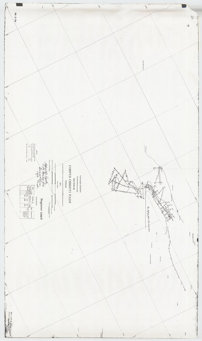
Print $40.00
- Digital $50.00
Hydrographic Survey H-1288B Corpus Christi Pass
1875
Size 52.9 x 31.4 inches
Map/Doc 2691
Flight Mission No. DQN-1K, Frame 155, Calhoun County

Print $20.00
- Digital $50.00
Flight Mission No. DQN-1K, Frame 155, Calhoun County
1953
Size 18.5 x 22.2 inches
Map/Doc 84214
Hutchinson County Sketch File 38

Print $40.00
- Digital $50.00
Hutchinson County Sketch File 38
1935
Size 17.6 x 14.2 inches
Map/Doc 27280
Tom Green County Sketch File 84

Print $20.00
- Digital $50.00
Tom Green County Sketch File 84
1890
Size 20.6 x 18.5 inches
Map/Doc 12456
[Right of Way and Track Map, the Missouri, Kansas and Texas Ry. of Texas - Henrietta Division]
![64759, [Right of Way and Track Map, the Missouri, Kansas and Texas Ry. of Texas - Henrietta Division], General Map Collection](https://historictexasmaps.com/wmedia_w700/maps/64759.tif.jpg)
Print $20.00
- Digital $50.00
[Right of Way and Track Map, the Missouri, Kansas and Texas Ry. of Texas - Henrietta Division]
1918
Size 11.9 x 26.8 inches
Map/Doc 64759