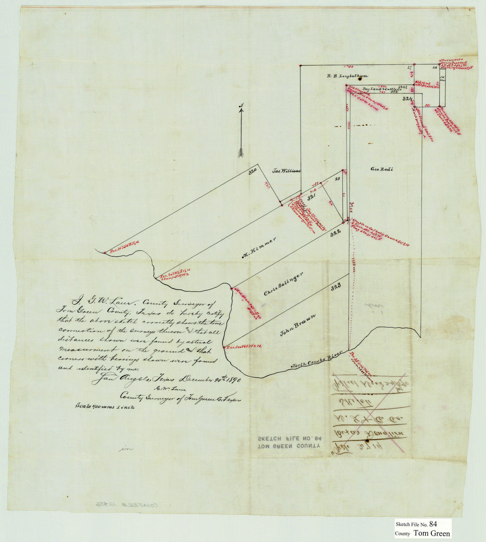
Tom Green County Sketch File 84
[Sketch of surveys just north of San Angelo]
-
Map/Doc
12456
-
Collection
General Map Collection
-
Object Dates
12/20/1890 (Creation Date)
12/24/1890 (File Date)
-
People and Organizations
G.W. Lane (Surveyor/Engineer)
-
Counties
Tom Green
-
Subjects
Surveying Sketch File
-
Height x Width
20.6 x 18.5 inches
52.3 x 47.0 cm
-
Medium
paper, manuscript
-
Scale
1" = 400 varas
-
Features
North Concho River
Part of: General Map Collection
Brazoria County Rolled Sketch 20

Print $20.00
- Digital $50.00
Brazoria County Rolled Sketch 20
1917
Size 31.1 x 47.1 inches
Map/Doc 8929
Crockett County Sketch File 35b

Print $20.00
- Digital $50.00
Crockett County Sketch File 35b
Size 13.9 x 8.8 inches
Map/Doc 19736
Map of Henderson County

Print $20.00
- Digital $50.00
Map of Henderson County
1871
Size 16.3 x 30.3 inches
Map/Doc 4563
Dickens County Rolled Sketch 13

Print $40.00
- Digital $50.00
Dickens County Rolled Sketch 13
1950
Size 43.4 x 53.7 inches
Map/Doc 45135
Palo Pinto County Boundary File 1

Print $4.00
- Digital $50.00
Palo Pinto County Boundary File 1
Size 12.8 x 8.4 inches
Map/Doc 57789
Reagan County Sketch File 24

Print $6.00
- Digital $50.00
Reagan County Sketch File 24
1940
Size 11.4 x 8.7 inches
Map/Doc 35018
Trinity River, White Rock Reservoir Sheet/White Rock Creek

Print $6.00
- Digital $50.00
Trinity River, White Rock Reservoir Sheet/White Rock Creek
1923
Size 36.3 x 16.7 inches
Map/Doc 65213
[FT. W. & R. G. Ry. Right of Way Map, Winchell to Brady, McCulloch County, Texas]
![61411, [FT. W. & R. G. Ry. Right of Way Map, Winchell to Brady, McCulloch County, Texas], General Map Collection](https://historictexasmaps.com/wmedia_w700/maps/61411.tif.jpg)
Print $20.00
- Digital $50.00
[FT. W. & R. G. Ry. Right of Way Map, Winchell to Brady, McCulloch County, Texas]
1918
Size 37.0 x 26.9 inches
Map/Doc 61411
Real County Rolled Sketch 18

Print $20.00
- Digital $50.00
Real County Rolled Sketch 18
Size 22.0 x 28.0 inches
Map/Doc 7463
Matagorda County Working Sketch 2

Print $20.00
- Digital $50.00
Matagorda County Working Sketch 2
Size 32.6 x 37.0 inches
Map/Doc 70860
Young County Working Sketch 17

Print $20.00
- Digital $50.00
Young County Working Sketch 17
1958
Size 20.7 x 28.6 inches
Map/Doc 62040
Hudspeth County Rolled Sketch 37

Print $20.00
- Digital $50.00
Hudspeth County Rolled Sketch 37
1938
Size 23.3 x 29.8 inches
Map/Doc 6250
You may also like

Stephens County Boundary File 6

Print $12.00
- Digital $50.00
Stephens County Boundary File 6
Size 13.0 x 8.5 inches
Map/Doc 58901
[Subdivision Plat of 80 acres]
![93075, [Subdivision Plat of 80 acres], Twichell Survey Records](https://historictexasmaps.com/wmedia_w700/maps/93075-1.tif.jpg)
Print $2.00
- Digital $50.00
[Subdivision Plat of 80 acres]
Size 11.7 x 6.2 inches
Map/Doc 93075
Cameron County Rolled Sketch 5

Print $20.00
- Digital $50.00
Cameron County Rolled Sketch 5
Size 35.8 x 38.8 inches
Map/Doc 8562
General Highway Map, Panola County, Texas

Print $20.00
General Highway Map, Panola County, Texas
1940
Size 18.2 x 24.6 inches
Map/Doc 79214
Stephens County Sketch File 10c

Print $6.00
- Digital $50.00
Stephens County Sketch File 10c
Size 7.8 x 11.5 inches
Map/Doc 37052
Stephens County Working Sketch 19

Print $40.00
- Digital $50.00
Stephens County Working Sketch 19
1969
Size 48.8 x 42.7 inches
Map/Doc 63962
Presidio County Working Sketch 140

Print $20.00
- Digital $50.00
Presidio County Working Sketch 140
1990
Size 29.8 x 39.9 inches
Map/Doc 71818
Parker County Working Sketch Graphic Index

Print $20.00
- Digital $50.00
Parker County Working Sketch Graphic Index
1942
Map/Doc 76661
Flight Mission No. CRC-4R, Frame 182, Chambers County

Print $20.00
- Digital $50.00
Flight Mission No. CRC-4R, Frame 182, Chambers County
1956
Size 18.5 x 22.1 inches
Map/Doc 84933
[Missouri, Kansas & Texas] E. L. & R. R. Railroad, Morris Co.
![64273, [Missouri, Kansas & Texas] E. L. & R. R. Railroad, Morris Co., General Map Collection](https://historictexasmaps.com/wmedia_w700/maps/64273.tif.jpg)
Print $20.00
- Digital $50.00
[Missouri, Kansas & Texas] E. L. & R. R. Railroad, Morris Co.
1906
Size 13.1 x 28.4 inches
Map/Doc 64273
The Land Offices. No. 5, Matagorda, December 22, 1836

Print $20.00
The Land Offices. No. 5, Matagorda, December 22, 1836
2020
Size 12.5 x 21.7 inches
Map/Doc 96418