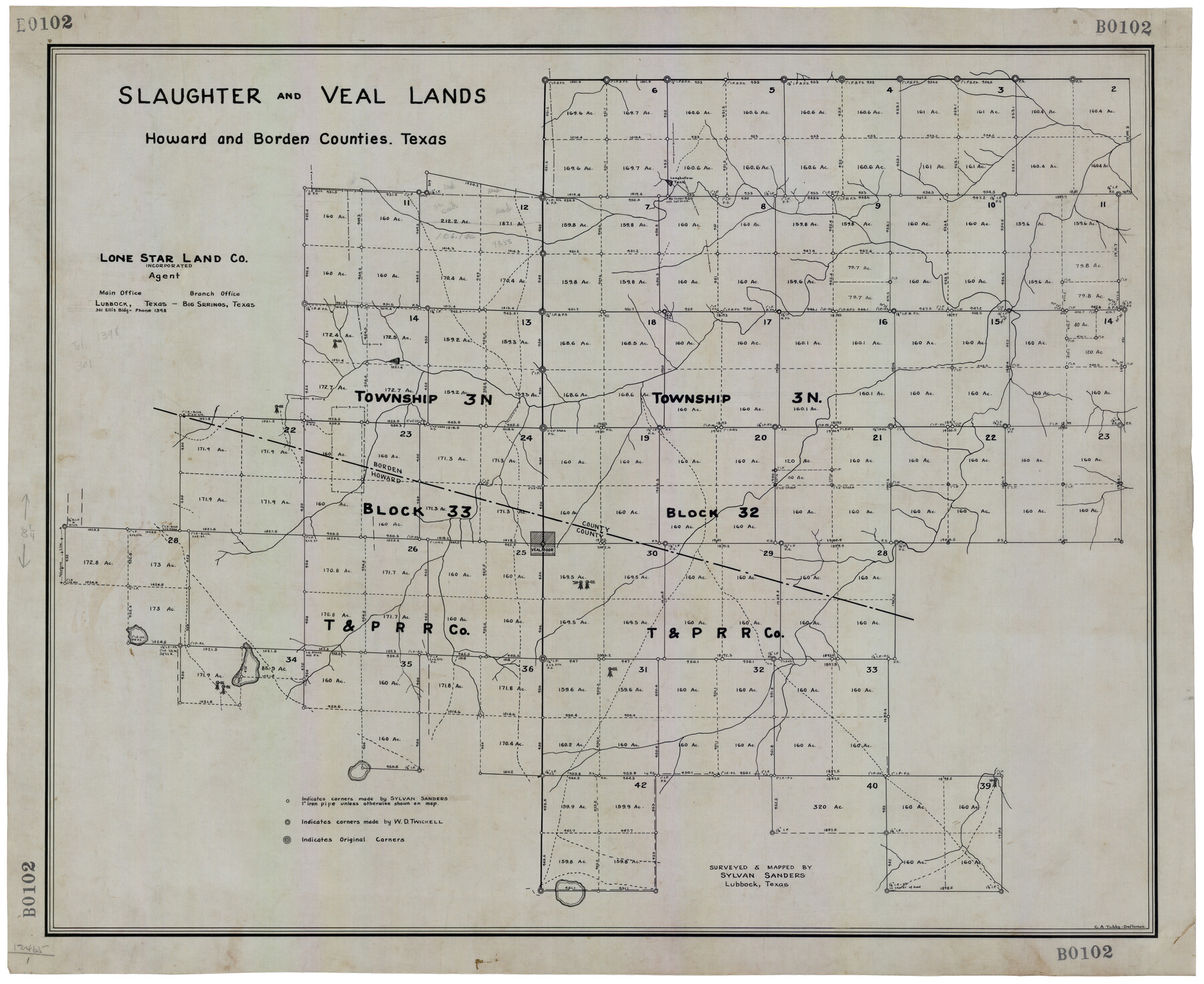
Slaughter and Veal Lands, Howard and Borden Counties, Texas
BO102
-
Map/Doc
92544
-
Collection
Twichell Survey Records
-
People and Organizations
Sylvan Sanders (Surveyor/Engineer)
C.A. Tubbs (Draftsman)
-
Counties
Borden Howard
-
Height x Width
33.5 x 27.3 inches
85.1 x 69.3 cm
Part of: Twichell Survey Records
Block 33, Township 5 South

Print $2.00
- Digital $50.00
Block 33, Township 5 South
1875
Size 8.9 x 9.7 inches
Map/Doc 90751
[South part Block AX and A21 and part of Block C44 and League 305]
![90798, [South part Block AX and A21 and part of Block C44 and League 305], Twichell Survey Records](https://historictexasmaps.com/wmedia_w700/maps/90798-1.tif.jpg)
Print $40.00
- Digital $50.00
[South part Block AX and A21 and part of Block C44 and League 305]
Size 49.3 x 23.5 inches
Map/Doc 90798
[Sections 47-76 and part of Block 3]
![91807, [Sections 47-76 and part of Block 3], Twichell Survey Records](https://historictexasmaps.com/wmedia_w700/maps/91807-1.tif.jpg)
Print $20.00
- Digital $50.00
[Sections 47-76 and part of Block 3]
Size 34.1 x 31.7 inches
Map/Doc 91807
Welch, Dawson County, Texas

Print $20.00
- Digital $50.00
Welch, Dawson County, Texas
Size 19.4 x 16.6 inches
Map/Doc 92592
Famous Heights Addition to Amarillo, Potter Co. Texas

Print $20.00
- Digital $50.00
Famous Heights Addition to Amarillo, Potter Co. Texas
Size 18.6 x 10.0 inches
Map/Doc 91744

Republic of Texas and Boundaries as Claimed by Texas from Decr. 19th, 1836 to Novr. 25th, 1850

Print $20.00
- Digital $50.00
Republic of Texas and Boundaries as Claimed by Texas from Decr. 19th, 1836 to Novr. 25th, 1850
Size 18.4 x 20.8 inches
Map/Doc 92063
[Sketch of most of Crosby County]
![89762, [Sketch of most of Crosby County], Twichell Survey Records](https://historictexasmaps.com/wmedia_w700/maps/89762-1.tif.jpg)
Print $40.00
- Digital $50.00
[Sketch of most of Crosby County]
Size 54.9 x 45.3 inches
Map/Doc 89762
Caldwell County

Print $20.00
- Digital $50.00
Caldwell County
1896
Size 42.7 x 33.3 inches
Map/Doc 93039
Working Sketch Crosby, Garza, Lynn, and Lubbock Counties

Print $20.00
- Digital $50.00
Working Sketch Crosby, Garza, Lynn, and Lubbock Counties
1904
Size 34.3 x 36.4 inches
Map/Doc 92695
[Blocks A, S4, T2, MO, and vicinity]
![91067, [Blocks A, S4, T2, MO, and vicinity], Twichell Survey Records](https://historictexasmaps.com/wmedia_w700/maps/91067-1.tif.jpg)
Print $3.00
- Digital $50.00
[Blocks A, S4, T2, MO, and vicinity]
Size 15.3 x 10.7 inches
Map/Doc 91067
[Sketch showing surveys on the north side of the Canadian River, Blocks B-11, L, O-18, and G and M 2 and 3]
![91737, [Sketch showing surveys on the north side of the Canadian River, Blocks B-11, L, O-18, and G and M 2 and 3], Twichell Survey Records](https://historictexasmaps.com/wmedia_w700/maps/91737-1.tif.jpg)
Print $20.00
- Digital $50.00
[Sketch showing surveys on the north side of the Canadian River, Blocks B-11, L, O-18, and G and M 2 and 3]
1883
Size 35.4 x 25.3 inches
Map/Doc 91737
You may also like
Starr County Working Sketch 8

Print $20.00
- Digital $50.00
Starr County Working Sketch 8
1939
Size 21.9 x 28.8 inches
Map/Doc 63924
Guadalupe County Working Sketch 2

Print $20.00
- Digital $50.00
Guadalupe County Working Sketch 2
1925
Size 37.2 x 19.2 inches
Map/Doc 63311
Clay County Sketch File 13

Print $8.00
- Digital $50.00
Clay County Sketch File 13
1875
Size 8.1 x 3.7 inches
Map/Doc 18413
Motley County Sketch File 3 (S)

Print $6.00
- Digital $50.00
Motley County Sketch File 3 (S)
Size 9.5 x 13.0 inches
Map/Doc 32141
Armstrong County Boundary File 2

Print $8.00
- Digital $50.00
Armstrong County Boundary File 2
Size 14.1 x 8.7 inches
Map/Doc 50137
University Land Field Notes for Blocks 34 through 37 in Terrell County

University Land Field Notes for Blocks 34 through 37 in Terrell County
Map/Doc 81720
Nolan County Rolled Sketch W

Print $20.00
- Digital $50.00
Nolan County Rolled Sketch W
1902
Size 16.5 x 38.0 inches
Map/Doc 6863
Kerr County Sketch File 5

Print $4.00
- Digital $50.00
Kerr County Sketch File 5
1878
Size 14.2 x 8.4 inches
Map/Doc 28865
McMullen County Sketch File 44

Print $6.00
- Digital $50.00
McMullen County Sketch File 44
1942
Size 14.2 x 8.8 inches
Map/Doc 31426
Dickens County Rolled Sketch H

Print $20.00
- Digital $50.00
Dickens County Rolled Sketch H
1902
Size 26.4 x 19.1 inches
Map/Doc 5712
Knox County Working Sketch 17

Print $20.00
- Digital $50.00
Knox County Working Sketch 17
1967
Size 36.8 x 27.1 inches
Map/Doc 70259
Crane County Rolled Sketch 23

Print $20.00
- Digital $50.00
Crane County Rolled Sketch 23
2002
Size 23.9 x 34.3 inches
Map/Doc 76426