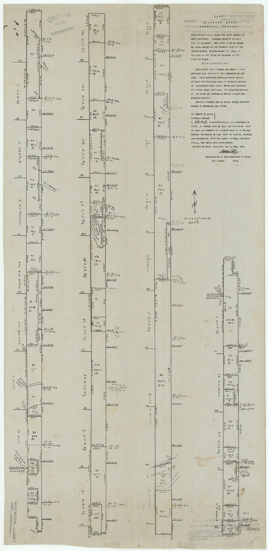
Hemphill County Rolled Sketch 11
Plat, Oklahoma Strip, Hemphill County being Block O.S.2. along the 100th degree of west longitude
-
Map/Doc
9152
-
Collection
General Map Collection
-
Object Dates
1941/5/8 (File Date)
1941/5/5 (Creation Date)
-
People and Organizations
A.B. Smith (Surveyor/Engineer)
-
Counties
Hemphill
-
Subjects
Surveying Rolled Sketch
-
Height x Width
45.4 x 22.2 inches
115.3 x 56.4 cm
-
Medium
linen, manuscript
-
Scale
1" = 400 varas
Part of: General Map Collection
Flight Mission No. BRE-1P, Frame 128, Nueces County

Print $20.00
- Digital $50.00
Flight Mission No. BRE-1P, Frame 128, Nueces County
1956
Size 18.3 x 22.1 inches
Map/Doc 86694
Navigation Maps of Gulf Intracoastal Waterway, Port Arthur to Brownsville, Texas

Print $4.00
- Digital $50.00
Navigation Maps of Gulf Intracoastal Waterway, Port Arthur to Brownsville, Texas
1951
Size 16.7 x 21.4 inches
Map/Doc 65423
Current Miscellaneous File 66

Print $34.00
- Digital $50.00
Current Miscellaneous File 66
Size 11.2 x 8.6 inches
Map/Doc 74113
Aransas County Rolled Sketch 31

Print $20.00
- Digital $50.00
Aransas County Rolled Sketch 31
1986
Size 30.0 x 41.4 inches
Map/Doc 77498
[Surveys in the Jefferson District: G. A. Patillo's league, Big Sandy, Sabine Bay]
![69727, [Surveys in the Jefferson District: G. A. Patillo's league, Big Sandy, Sabine Bay], General Map Collection](https://historictexasmaps.com/wmedia_w700/maps/69727-1.tif.jpg)
Print $20.00
- Digital $50.00
[Surveys in the Jefferson District: G. A. Patillo's league, Big Sandy, Sabine Bay]
1846
Size 14.4 x 20.9 inches
Map/Doc 69727

Map of Coleman County

Print $20.00
- Digital $50.00
Map of Coleman County
Size 26.8 x 19.8 inches
Map/Doc 3408
Falls of St. Anthony

Print $2.00
- Digital $50.00
Falls of St. Anthony
1810
Size 6.2 x 8.8 inches
Map/Doc 95152
Eastland County Working Sketch 47

Print $20.00
- Digital $50.00
Eastland County Working Sketch 47
1981
Size 30.0 x 27.1 inches
Map/Doc 68828
Kendall County Working Sketch 2

Print $20.00
- Digital $50.00
Kendall County Working Sketch 2
1941
Size 28.6 x 21.1 inches
Map/Doc 66674
Hudspeth County Rolled Sketch 57

Print $20.00
- Digital $50.00
Hudspeth County Rolled Sketch 57
Size 38.3 x 46.0 inches
Map/Doc 9223
Aransas County Working Sketch 2

Print $3.00
- Digital $50.00
Aransas County Working Sketch 2
1926
Size 16.3 x 9.7 inches
Map/Doc 67169
You may also like
English Field Notes of the Spanish Archives - Books DB3 & WR

English Field Notes of the Spanish Archives - Books DB3 & WR
1835
Map/Doc 96548
![94186, Texas [Verso], General Map Collection](https://historictexasmaps.com/wmedia_w700/maps/94186.tif.jpg)
Map of Townsite of Swearingen, Cottle County, Texas

Print $20.00
- Digital $50.00
Map of Townsite of Swearingen, Cottle County, Texas
1918
Size 28.8 x 17.4 inches
Map/Doc 4464
Texas Gulf Coast, from the Sabine River to the Rio Grande as Subdivided for Mineral Development; Jefferson, Chambers and Galveston Counties

Print $20.00
- Digital $50.00
Texas Gulf Coast, from the Sabine River to the Rio Grande as Subdivided for Mineral Development; Jefferson, Chambers and Galveston Counties
1976
Size 29.0 x 42.5 inches
Map/Doc 1937
Hardeman Co[unty]
![16845, Hardeman Co[unty], General Map Collection](https://historictexasmaps.com/wmedia_w700/maps/16845.tif.jpg)
Print $40.00
- Digital $50.00
Hardeman Co[unty]
1886
Size 60.7 x 48.8 inches
Map/Doc 16845
Guadalupe County Working Sketch 4

Print $20.00
- Digital $50.00
Guadalupe County Working Sketch 4
1939
Size 17.7 x 10.8 inches
Map/Doc 63313
General Highway Map, Harrison County, Texas

Print $20.00
General Highway Map, Harrison County, Texas
1940
Size 18.2 x 24.8 inches
Map/Doc 79121

Oso Creek, Cudahay Field (P-3) Sheet

Print $6.00
- Digital $50.00
Oso Creek, Cudahay Field (P-3) Sheet
1942
Size 30.6 x 33.8 inches
Map/Doc 65098
Controlled Mosaic by Jack Amman Photogrammetric Engineers, Inc - Sheet 41

Print $20.00
- Digital $50.00
Controlled Mosaic by Jack Amman Photogrammetric Engineers, Inc - Sheet 41
1954
Size 20.0 x 24.0 inches
Map/Doc 83496
Pecos County Working Sketch 124

Print $40.00
- Digital $50.00
Pecos County Working Sketch 124
1974
Size 57.9 x 38.2 inches
Map/Doc 71597
Current Miscellaneous File 13

Print $20.00
- Digital $50.00
Current Miscellaneous File 13
Size 16.2 x 21.6 inches
Map/Doc 73820