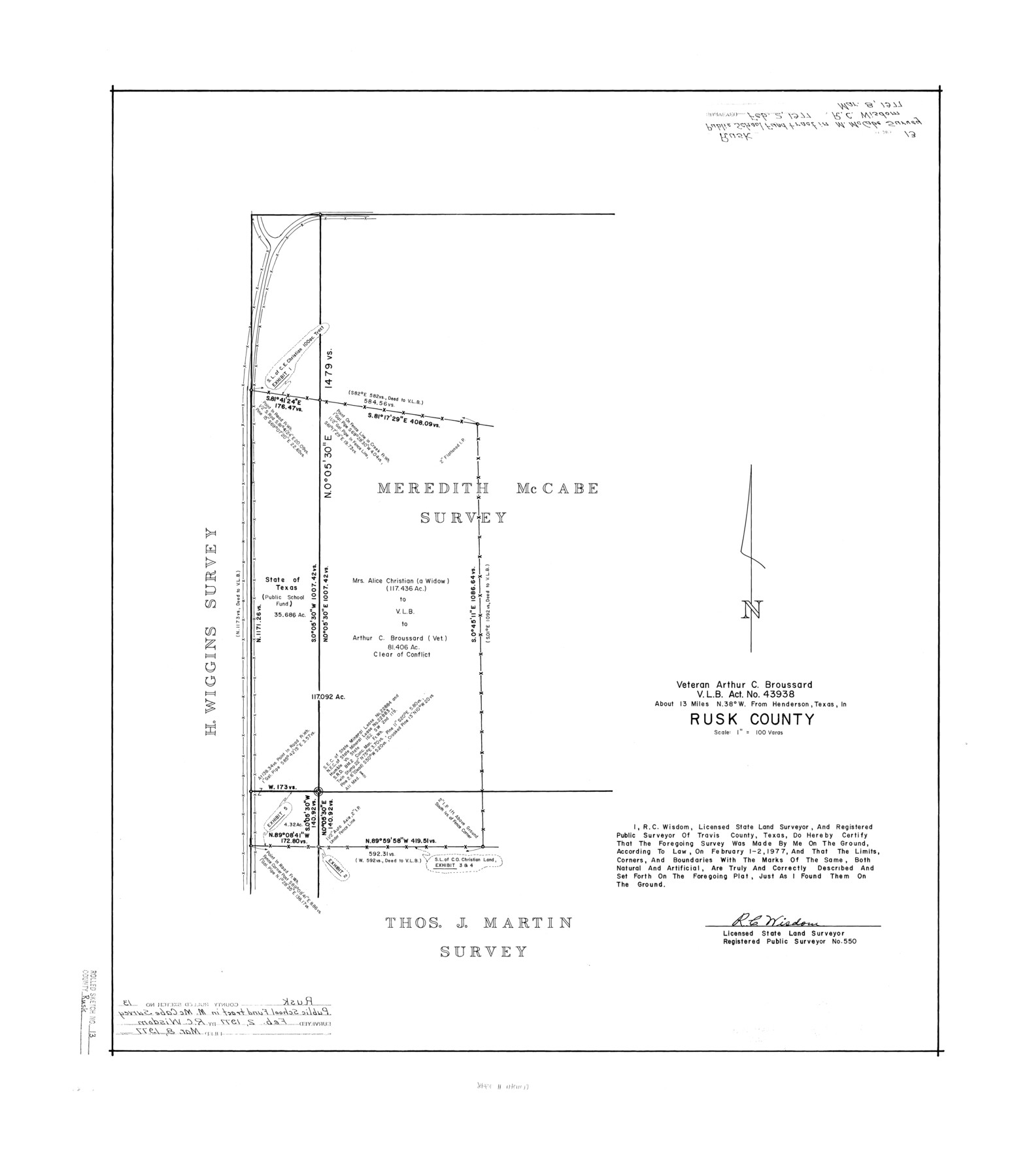
Rusk County Rolled Sketch 13
Veteran Arthur C. Broussard VLB act. no. 43938
-
Map/Doc
7548
-
Collection
General Map Collection
-
Object Dates
1977/3/8 (File Date)
1977/2/1 (Survey Date)
1977/2/2 (Survey Date)
-
People and Organizations
R.C. Wisdom (Surveyor/Engineer)
-
Counties
Rusk
-
Subjects
Surveying Rolled Sketch
-
Height x Width
30.1 x 26.4 inches
76.5 x 67.1 cm
-
Medium
mylar, print
-
Scale
1" = 100 varas
Part of: General Map Collection
Nueces County NRC Article 33.136 Location Key Sheet

Print $20.00
- Digital $50.00
Nueces County NRC Article 33.136 Location Key Sheet
1975
Size 27.0 x 23.0 inches
Map/Doc 88586
Crockett County Rolled Sketch 43

Print $40.00
- Digital $50.00
Crockett County Rolled Sketch 43
1937
Size 31.4 x 63.2 inches
Map/Doc 8708
Kent County Boundary File 7

Print $6.00
- Digital $50.00
Kent County Boundary File 7
Size 10.8 x 8.7 inches
Map/Doc 55870
Matagorda County Rolled Sketch 33

Print $40.00
- Digital $50.00
Matagorda County Rolled Sketch 33
1957
Size 43.5 x 63.0 inches
Map/Doc 9482
Howard County Boundary File 3

Print $51.00
- Digital $50.00
Howard County Boundary File 3
Size 9.3 x 4.5 inches
Map/Doc 55130
Floyd County Sketch File A1

Print $4.00
- Digital $50.00
Floyd County Sketch File A1
Size 9.2 x 7.9 inches
Map/Doc 22686
Flight Mission No. BRA-7M, Frame 42, Jefferson County

Print $20.00
- Digital $50.00
Flight Mission No. BRA-7M, Frame 42, Jefferson County
1953
Size 18.6 x 22.3 inches
Map/Doc 85493
Amistad International Reservoir on Rio Grande 110

Print $20.00
- Digital $50.00
Amistad International Reservoir on Rio Grande 110
1950
Size 41.4 x 29.5 inches
Map/Doc 75541
Archer County Sketch File 17

Print $4.00
- Digital $50.00
Archer County Sketch File 17
1901
Size 11.3 x 8.6 inches
Map/Doc 13653
Flight Mission No. DQO-1K, Frame 94, Galveston County

Print $20.00
- Digital $50.00
Flight Mission No. DQO-1K, Frame 94, Galveston County
1952
Size 18.9 x 22.6 inches
Map/Doc 84990
Webb County Rolled Sketch 64

Print $20.00
- Digital $50.00
Webb County Rolled Sketch 64
1948
Size 42.0 x 27.3 inches
Map/Doc 8213
Baylor County Sketch File A6

Print $80.00
- Digital $50.00
Baylor County Sketch File A6
1899
Size 22.5 x 31.7 inches
Map/Doc 10912
You may also like
The Land Grants of Texas

Print $20.00
The Land Grants of Texas
2014
Size 28.0 x 36.2 inches
Map/Doc 93698
Flight Mission No. BRA-16M, Frame 66, Jefferson County

Print $20.00
- Digital $50.00
Flight Mission No. BRA-16M, Frame 66, Jefferson County
1953
Size 18.6 x 22.3 inches
Map/Doc 85683
Carson County Boundary File 10

Print $2.00
- Digital $50.00
Carson County Boundary File 10
Size 11.5 x 7.2 inches
Map/Doc 51185
Roberts County Working Sketch 3

Print $20.00
- Digital $50.00
Roberts County Working Sketch 3
1949
Size 18.0 x 14.3 inches
Map/Doc 63529
Geological Map of the Great East Texas Oil Fields

Print $20.00
- Digital $50.00
Geological Map of the Great East Texas Oil Fields
1921
Size 22.6 x 11.7 inches
Map/Doc 94271
Val Verde County Sketch File 4

Print $30.00
- Digital $50.00
Val Verde County Sketch File 4
1888
Size 28.0 x 20.6 inches
Map/Doc 12561
Sterling County Rolled Sketch 38

Print $20.00
- Digital $50.00
Sterling County Rolled Sketch 38
1988
Size 25.0 x 31.7 inches
Map/Doc 7863
Plat of Resurvey of Sections 4, 9, 10 and 23, T. 5S., R. 13W., of the Indian Meridian, Oklahoma

Print $4.00
- Digital $50.00
Plat of Resurvey of Sections 4, 9, 10 and 23, T. 5S., R. 13W., of the Indian Meridian, Oklahoma
1917
Size 18.0 x 22.6 inches
Map/Doc 75143
Outer Continental Shelf Leasing Maps (Texas Offshore Operations)

Print $20.00
- Digital $50.00
Outer Continental Shelf Leasing Maps (Texas Offshore Operations)
1954
Size 22.3 x 17.3 inches
Map/Doc 75833
Galveston County NRC Article 33.136 Sketch 35

Print $42.00
- Digital $50.00
Galveston County NRC Article 33.136 Sketch 35
2005
Size 24.3 x 36.6 inches
Map/Doc 83406
Bell County Sketch File 34

Print $40.00
- Digital $50.00
Bell County Sketch File 34
Size 15.4 x 13.4 inches
Map/Doc 14455
