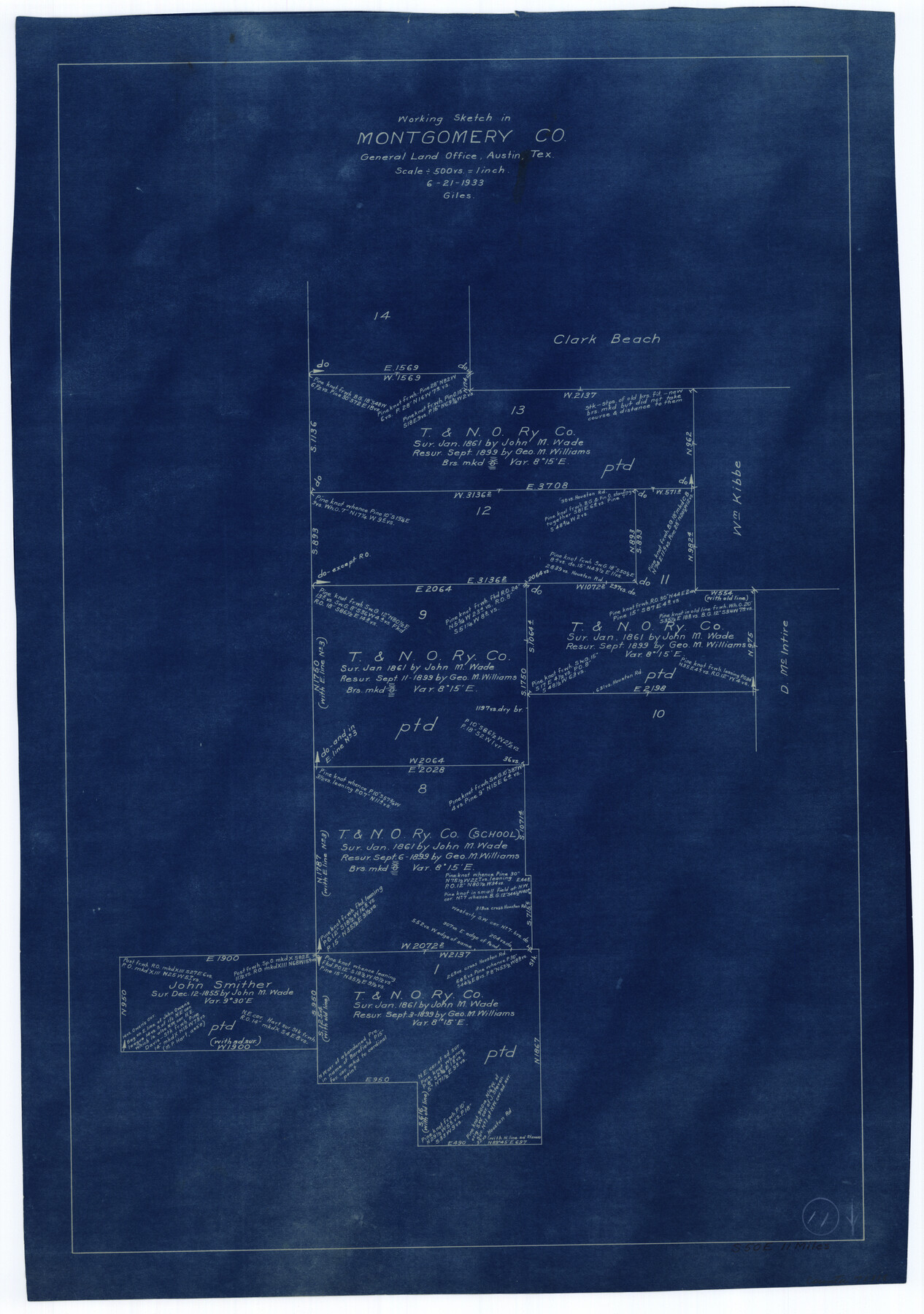
Montgomery County Working Sketch 11
-
Map/Doc
71118
-
Collection
General Map Collection
-
Object Dates
6/21/1933 (Creation Date)
-
People and Organizations
J. Bascom Giles (Draftsman)
-
Counties
Montgomery
-
Subjects
Surveying Working Sketch
-
Height x Width
25.2 x 17.7 inches
64.0 x 45.0 cm
-
Scale
1" = 500 varas
Part of: General Map Collection
Coke County Sketch File 36

Print $24.00
- Digital $50.00
Coke County Sketch File 36
1918
Size 14.1 x 8.5 inches
Map/Doc 18652
San Jacinto County Sketch File 13

Print $4.00
San Jacinto County Sketch File 13
Size 5.3 x 8.1 inches
Map/Doc 35723
Bandera County Working Sketch 32

Print $20.00
- Digital $50.00
Bandera County Working Sketch 32
1956
Size 22.7 x 18.4 inches
Map/Doc 67628
Flight Mission No. BRA-7M, Frame 199, Jefferson County

Print $20.00
- Digital $50.00
Flight Mission No. BRA-7M, Frame 199, Jefferson County
1953
Size 18.7 x 22.4 inches
Map/Doc 85567
Flight Mission No. BQR-5K, Frame 71, Brazoria County

Print $20.00
- Digital $50.00
Flight Mission No. BQR-5K, Frame 71, Brazoria County
1952
Size 18.8 x 22.4 inches
Map/Doc 84016
Culberson County Working Sketch 70

Print $40.00
- Digital $50.00
Culberson County Working Sketch 70
1975
Size 50.3 x 32.2 inches
Map/Doc 68524
San Patricio County Rolled Sketch 36

Print $40.00
- Digital $50.00
San Patricio County Rolled Sketch 36
Size 42.3 x 48.1 inches
Map/Doc 9899
Flight Mission No. DQN-1K, Frame 31, Calhoun County

Print $20.00
- Digital $50.00
Flight Mission No. DQN-1K, Frame 31, Calhoun County
1953
Size 15.4 x 15.5 inches
Map/Doc 84136
Van Zandt County Sketch File 15a

Print $4.00
- Digital $50.00
Van Zandt County Sketch File 15a
1858
Size 6.7 x 8.1 inches
Map/Doc 39406
Kimble County Working Sketch 95

Print $20.00
- Digital $50.00
Kimble County Working Sketch 95
1994
Size 36.2 x 45.9 inches
Map/Doc 70163

Flight Mission No. DQN-5K, Frame 56, Calhoun County

Print $20.00
- Digital $50.00
Flight Mission No. DQN-5K, Frame 56, Calhoun County
1953
Size 15.7 x 15.5 inches
Map/Doc 84399
You may also like
Henderson County Sketch File 20

Print $20.00
- Digital $50.00
Henderson County Sketch File 20
Size 23.7 x 23.5 inches
Map/Doc 11757
Dallas County Working Sketch 19

Print $20.00
- Digital $50.00
Dallas County Working Sketch 19
1997
Size 23.1 x 30.3 inches
Map/Doc 68585
Presidio County Working Sketch 91

Print $40.00
- Digital $50.00
Presidio County Working Sketch 91
1974
Size 42.0 x 59.4 inches
Map/Doc 71768
Yellowhouse Land Company's Subdivision of Spade Ranch Lands Situated in Lamb and Hockley Counties, Texas

Print $20.00
- Digital $50.00
Yellowhouse Land Company's Subdivision of Spade Ranch Lands Situated in Lamb and Hockley Counties, Texas
Size 21.5 x 22.5 inches
Map/Doc 92228
[Kansas City, Mexico & Orient] Located Line of the Panhandle and Gulf RY. Through Stand Lands, Public School and University, In Presidio County Texas, Right of Way 200 feet Wide
![64269, [Kansas City, Mexico & Orient] Located Line of the Panhandle and Gulf RY. Through Stand Lands, Public School and University, In Presidio County Texas, Right of Way 200 feet Wide, General Map Collection](https://historictexasmaps.com/wmedia_w700/maps/64269-1.tif.jpg)
Print $40.00
- Digital $50.00
[Kansas City, Mexico & Orient] Located Line of the Panhandle and Gulf RY. Through Stand Lands, Public School and University, In Presidio County Texas, Right of Way 200 feet Wide
1904
Size 15.6 x 70.3 inches
Map/Doc 64269
Hidalgo County Sketch File 9

Print $40.00
- Digital $50.00
Hidalgo County Sketch File 9
1904
Size 8.8 x 5.7 inches
Map/Doc 26409
[Blocks T1, T2, T3, S3, A, 05, 02 and vicinity]
![92196, [Blocks T1, T2, T3, S3, A, 05, 02 and vicinity], Twichell Survey Records](https://historictexasmaps.com/wmedia_w700/maps/92196-1.tif.jpg)
Print $20.00
- Digital $50.00
[Blocks T1, T2, T3, S3, A, 05, 02 and vicinity]
Size 20.3 x 22.9 inches
Map/Doc 92196
Madison County Working Sketch 12

Print $40.00
- Digital $50.00
Madison County Working Sketch 12
1965
Size 41.7 x 48.5 inches
Map/Doc 70774
Anderson County Sketch File 5

Print $6.00
- Digital $50.00
Anderson County Sketch File 5
1856
Size 9.7 x 7.8 inches
Map/Doc 12750
Edwards County Working Sketch 69

Print $20.00
- Digital $50.00
Edwards County Working Sketch 69
1957
Size 20.3 x 22.5 inches
Map/Doc 68945
Montgomery County Rolled Sketch 51

Print $20.00
- Digital $50.00
Montgomery County Rolled Sketch 51
2021
Map/Doc 97369
Map of S. E. Pecos County with a part of Crockett County, Texas

Print $40.00
- Digital $50.00
Map of S. E. Pecos County with a part of Crockett County, Texas
1927
Size 42.2 x 51.6 inches
Map/Doc 89804