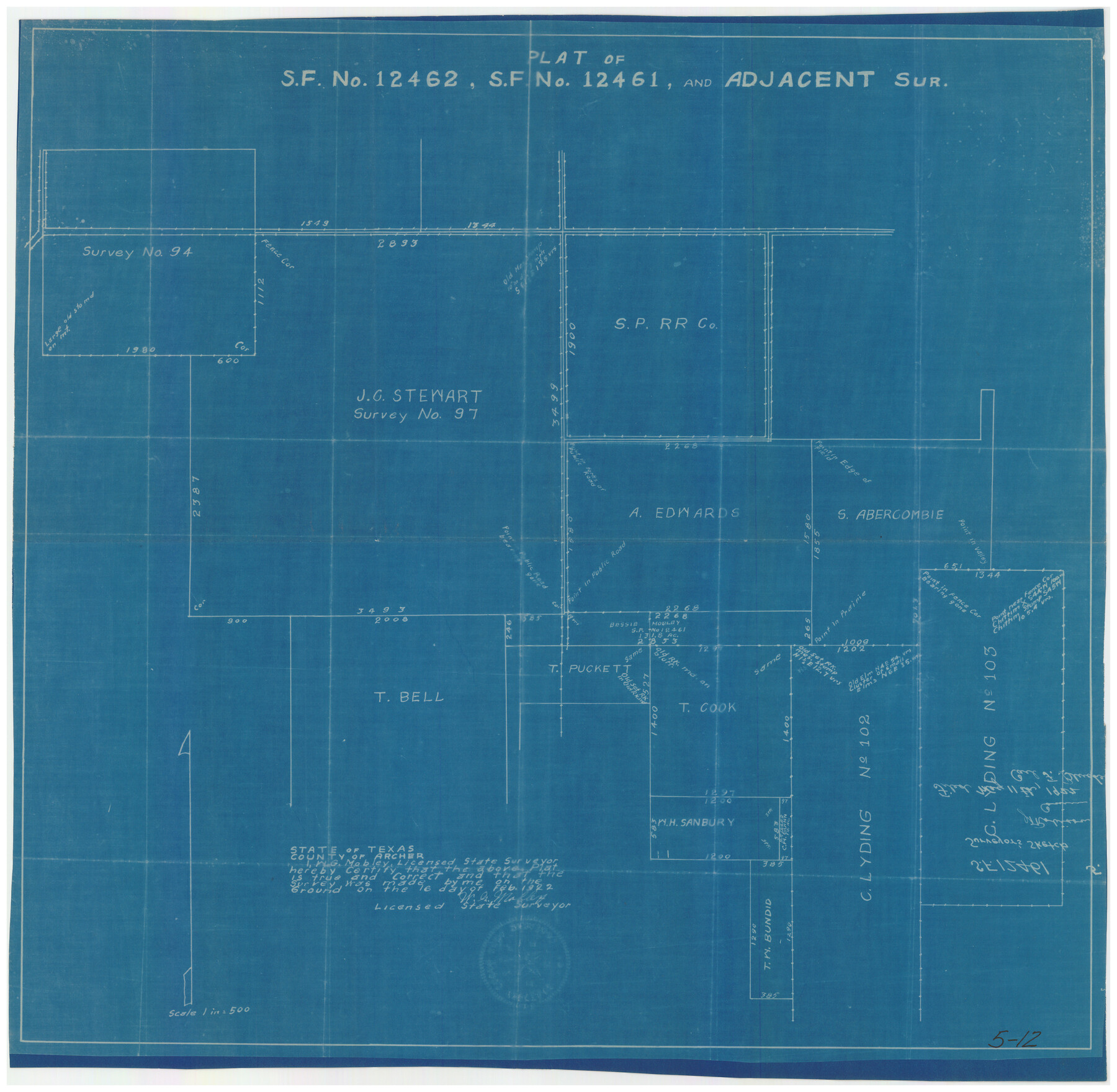
Plat of S. F. No. 12462, S. F. No. 12461, and Adjacent Sur.
5-12
-
Map/Doc
90172
-
Collection
Twichell Survey Records
-
Object Dates
2/16/1922 (Creation Date)
-
People and Organizations
W.G. Mobley (Surveyor/Engineer)
-
Counties
Archer
-
Height x Width
21.2 x 20.1 inches
53.9 x 51.1 cm
Part of: Twichell Survey Records
Secs. 58-69, I&GN Blk. 1

Print $20.00
- Digital $50.00
Secs. 58-69, I&GN Blk. 1
Size 27.5 x 25.3 inches
Map/Doc 91617
[Western part of Crockett County]
![90323, [Western part of Crockett County], Twichell Survey Records](https://historictexasmaps.com/wmedia_w700/maps/90323-1.tif.jpg)
Print $20.00
- Digital $50.00
[Western part of Crockett County]
Size 17.3 x 14.3 inches
Map/Doc 90323

[Plainview with Highland Addition]
![92662, [Plainview with Highland Addition], Twichell Survey Records](https://historictexasmaps.com/wmedia_w700/maps/92662-1.tif.jpg)
Print $40.00
- Digital $50.00
[Plainview with Highland Addition]
Size 54.0 x 27.4 inches
Map/Doc 92662
[Nathaniel H. Cochran Survey and Vicinity]
![91494, [Nathaniel H. Cochran Survey and Vicinity], Twichell Survey Records](https://historictexasmaps.com/wmedia_w700/maps/91494-1.tif.jpg)
Print $20.00
- Digital $50.00
[Nathaniel H. Cochran Survey and Vicinity]
Size 26.7 x 18.8 inches
Map/Doc 91494
[Capitol Leagues 217-228, 238, and vicinity]
![90672, [Capitol Leagues 217-228, 238, and vicinity], Twichell Survey Records](https://historictexasmaps.com/wmedia_w700/maps/90672-1.tif.jpg)
Print $20.00
- Digital $50.00
[Capitol Leagues 217-228, 238, and vicinity]
Size 23.0 x 9.9 inches
Map/Doc 90672
[Capitol Leagues 661-729]
![91187, [Capitol Leagues 661-729], Twichell Survey Records](https://historictexasmaps.com/wmedia_w700/maps/91187-1.tif.jpg)
Print $20.00
- Digital $50.00
[Capitol Leagues 661-729]
Size 20.6 x 28.6 inches
Map/Doc 91187
[Blocks 1 and H]
![90719, [Blocks 1 and H], Twichell Survey Records](https://historictexasmaps.com/wmedia_w700/maps/90719-1.tif.jpg)
Print $20.00
- Digital $50.00
[Blocks 1 and H]
Size 27.1 x 21.6 inches
Map/Doc 90719
Sketch Showing Original Corners Affecting Block I and Adjacent Surveys from Actual Connections by W. D. Twichell

Print $20.00
- Digital $50.00
Sketch Showing Original Corners Affecting Block I and Adjacent Surveys from Actual Connections by W. D. Twichell
Size 23.9 x 24.2 inches
Map/Doc 90285
[Sketch showing San Augustine, Morris, Stephens and Eastland School Land Leagues and adjacent Blocks]
![89918, [Sketch showing San Augustine, Morris, Stephens and Eastland School Land Leagues and adjacent Blocks], Twichell Survey Records](https://historictexasmaps.com/wmedia_w700/maps/89918-1.tif.jpg)
Print $40.00
- Digital $50.00
[Sketch showing San Augustine, Morris, Stephens and Eastland School Land Leagues and adjacent Blocks]
Size 54.7 x 43.5 inches
Map/Doc 89918
Sheet 5 copied from Champlin Book 5 [Strip Map showing T. & P. connecting lines]
![93180, Sheet 5 copied from Champlin Book 5 [Strip Map showing T. & P. connecting lines], Twichell Survey Records](https://historictexasmaps.com/wmedia_w700/maps/93180-1.tif.jpg)
Print $40.00
- Digital $50.00
Sheet 5 copied from Champlin Book 5 [Strip Map showing T. & P. connecting lines]
1909
Size 7.9 x 75.6 inches
Map/Doc 93180
[Block 3 Sections 322, 321, 319, Block 1 Section 1]
![92938, [Block 3 Sections 322, 321, 319, Block 1 Section 1], Twichell Survey Records](https://historictexasmaps.com/wmedia_w700/maps/92938-1.tif.jpg)
Print $20.00
- Digital $50.00
[Block 3 Sections 322, 321, 319, Block 1 Section 1]
Size 21.1 x 20.4 inches
Map/Doc 92938
You may also like
Little River, Faubion Bridge Sheet

Print $20.00
- Digital $50.00
Little River, Faubion Bridge Sheet
1914
Size 18.5 x 27.6 inches
Map/Doc 69682
Sketch in Martin County Showing Survey 13, Block X

Print $2.00
- Digital $50.00
Sketch in Martin County Showing Survey 13, Block X
1908
Size 12.6 x 8.4 inches
Map/Doc 91286
Edwards County Working Sketch 128

Print $20.00
- Digital $50.00
Edwards County Working Sketch 128
1981
Size 26.5 x 32.4 inches
Map/Doc 69004
Dallas County Rolled Sketch 3A

Print $40.00
- Digital $50.00
Dallas County Rolled Sketch 3A
1953
Size 29.9 x 78.8 inches
Map/Doc 8768
Map of Terry County

Print $20.00
- Digital $50.00
Map of Terry County
1901
Size 43.1 x 39.8 inches
Map/Doc 16892
La Salle County Sketch File 34

Print $6.00
- Digital $50.00
La Salle County Sketch File 34
Size 15.8 x 9.5 inches
Map/Doc 29585
Clay County Working Sketch 12

Print $20.00
- Digital $50.00
Clay County Working Sketch 12
1955
Size 30.6 x 39.4 inches
Map/Doc 68035

Pecos County Rolled Sketch 144

Print $20.00
- Digital $50.00
Pecos County Rolled Sketch 144
1956
Size 28.5 x 29.8 inches
Map/Doc 7277
Flight Mission No. DAG-21K, Frame 95, Matagorda County

Print $20.00
- Digital $50.00
Flight Mission No. DAG-21K, Frame 95, Matagorda County
1952
Size 18.6 x 22.2 inches
Map/Doc 86424
[Divisional Boundary and Brigade Boundary on October 22, 1918, Appendix P]
![94125, [Divisional Boundary and Brigade Boundary on October 22, 1918, Appendix P], Non-GLO Digital Images](https://historictexasmaps.com/wmedia_w700/maps/94125-1.tif.jpg)
Print $20.00
[Divisional Boundary and Brigade Boundary on October 22, 1918, Appendix P]
1918
Size 16.2 x 16.7 inches
Map/Doc 94125
Topographical Map of the Rio Grande, Sheet No. 30

Print $20.00
- Digital $50.00
Topographical Map of the Rio Grande, Sheet No. 30
1912
Map/Doc 89554