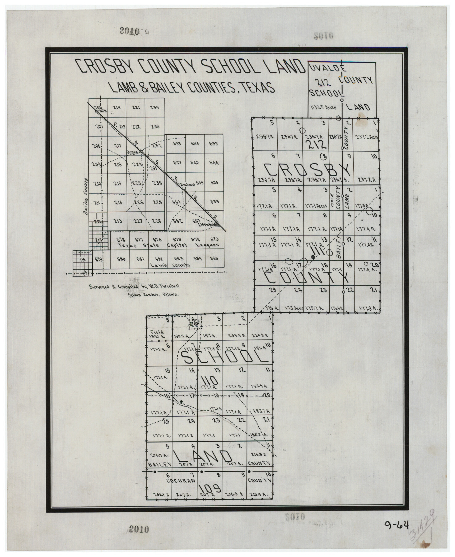
Crosby County School Land, Lamb and Bailey Counties
9-64
-
Map/Doc
90109
-
Collection
Twichell Survey Records
-
People and Organizations
Sylvan Sanders (Draftsman)
W.D. Twichell (Compiler)
W.D. Twichell (Surveyor/Engineer)
-
Counties
Bailey
-
Height x Width
12.4 x 14.9 inches
31.5 x 37.9 cm
Part of: Twichell Survey Records
[Leagues 575, 578, 609, and 616, Blocks T2, T3, and K13]
![91053, [Leagues 575, 578, 609, and 616, Blocks T2, T3, and K13], Twichell Survey Records](https://historictexasmaps.com/wmedia_w700/maps/91053-1.tif.jpg)
Print $20.00
- Digital $50.00
[Leagues 575, 578, 609, and 616, Blocks T2, T3, and K13]
Size 20.5 x 20.0 inches
Map/Doc 91053
Tahoka Heights Addition to Tahoka Located on the SE Quarter of Section 568

Print $20.00
- Digital $50.00
Tahoka Heights Addition to Tahoka Located on the SE Quarter of Section 568
Size 18.1 x 18.5 inches
Map/Doc 92939
Ownership Map Upton Co., Texas

Ownership Map Upton Co., Texas
1951
Size 45.6 x 56.9 inches
Map/Doc 89904
Portion of Scurry County

Print $20.00
- Digital $50.00
Portion of Scurry County
1882
Size 35.1 x 25.3 inches
Map/Doc 92923
Map of Claude - Claude, Armstrong Co.

Print $20.00
- Digital $50.00
Map of Claude - Claude, Armstrong Co.
Size 46.9 x 38.5 inches
Map/Doc 89743
[Randall County School Land League 152 and vicinity]
![92998, [Randall County School Land League 152 and vicinity], Twichell Survey Records](https://historictexasmaps.com/wmedia_w700/maps/92998.tif.jpg)
Print $3.00
- Digital $50.00
[Randall County School Land League 152 and vicinity]
1949
Size 15.0 x 10.9 inches
Map/Doc 92998
Sketch showing resurvey of Blk 34 Tsp. 4 North

Print $20.00
- Digital $50.00
Sketch showing resurvey of Blk 34 Tsp. 4 North
1917
Size 20.8 x 24.5 inches
Map/Doc 90571
[PSL Blocks C43 and C44 and Dawson and Gaines County School Lands]
![90813, [PSL Blocks C43 and C44 and Dawson and Gaines County School Lands], Twichell Survey Records](https://historictexasmaps.com/wmedia_w700/maps/90813-2.tif.jpg)
Print $3.00
- Digital $50.00
[PSL Blocks C43 and C44 and Dawson and Gaines County School Lands]
1950
Size 9.5 x 15.8 inches
Map/Doc 90813
[Blocks JD, B, D10, A2, A3]
![90777, [Blocks JD, B, D10, A2, A3], Twichell Survey Records](https://historictexasmaps.com/wmedia_w700/maps/90777-1.tif.jpg)
Print $2.00
- Digital $50.00
[Blocks JD, B, D10, A2, A3]
Size 7.3 x 13.4 inches
Map/Doc 90777
Map Showing Jacob Kuechler's Meander of West Bank of Pecos River in December 1876

Print $20.00
- Digital $50.00
Map Showing Jacob Kuechler's Meander of West Bank of Pecos River in December 1876
Size 18.6 x 17.4 inches
Map/Doc 91669
[Area Surrounding Charles Ragsdale, M. George, and H. Ward Surveys]
![91535, [Area Surrounding Charles Ragsdale, M. George, and H. Ward Surveys], Twichell Survey Records](https://historictexasmaps.com/wmedia_w700/maps/91535-1.tif.jpg)
Print $20.00
- Digital $50.00
[Area Surrounding Charles Ragsdale, M. George, and H. Ward Surveys]
Size 20.0 x 23.3 inches
Map/Doc 91535
John B. Slaughter Ranch Situated in Garza County, Texas

Print $20.00
- Digital $50.00
John B. Slaughter Ranch Situated in Garza County, Texas
Size 33.2 x 45.1 inches
Map/Doc 92658
You may also like
Presidio County Working Sketch 86

Print $20.00
- Digital $50.00
Presidio County Working Sketch 86
1971
Size 45.4 x 42.2 inches
Map/Doc 71763
Angelina County Sketch File 15c

Print $16.00
- Digital $50.00
Angelina County Sketch File 15c
1838
Size 12.2 x 8.0 inches
Map/Doc 12972
Limestone County Sketch File 10b

Print $22.00
- Digital $50.00
Limestone County Sketch File 10b
1875
Size 15.0 x 14.1 inches
Map/Doc 30175
Cass County Working Sketch 3

Print $20.00
- Digital $50.00
Cass County Working Sketch 3
1936
Size 34.3 x 38.5 inches
Map/Doc 67906
Crockett County Sketch File 23

Print $2.00
- Digital $50.00
Crockett County Sketch File 23
Size 8.6 x 8.5 inches
Map/Doc 19697
Arthur E. Miller Irrigated Farm West Half Section 19, Block D6

Print $20.00
- Digital $50.00
Arthur E. Miller Irrigated Farm West Half Section 19, Block D6
Size 11.9 x 21.8 inches
Map/Doc 92317
Jefferson County Rolled Sketch 12

Print $2.00
- Digital $50.00
Jefferson County Rolled Sketch 12
Size 12.2 x 7.1 inches
Map/Doc 9279
Kent County Boundary File 7

Print $6.00
- Digital $50.00
Kent County Boundary File 7
Size 10.8 x 8.7 inches
Map/Doc 55870
Aransas County Working Sketch 20

Print $20.00
- Digital $50.00
Aransas County Working Sketch 20
1980
Size 11.9 x 24.4 inches
Map/Doc 67187

Old Miscellaneous File 33

Print $4.00
- Digital $50.00
Old Miscellaneous File 33
1874
Size 9.8 x 8.1 inches
Map/Doc 75753
Map of Grimes County, Texas

Print $20.00
- Digital $50.00
Map of Grimes County, Texas
1880
Size 29.5 x 15.6 inches
Map/Doc 432