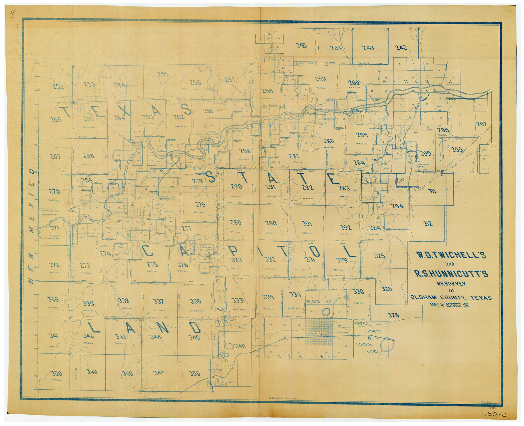
W. D. Twichell's and R. S. Hunnicutt's Resurvey in Oldham County, Texas May to October, 1916
180-6
-
Map/Doc
89975
-
Collection
Twichell Survey Records
-
Object Dates
10/1915 (Creation Date)
-
Counties
Oldham
-
Height x Width
48.0 x 39.0 inches
121.9 x 99.1 cm
Part of: Twichell Survey Records
[Sketch showing surveys located in Block 6]
![91751, [Sketch showing surveys located in Block 6], Twichell Survey Records](https://historictexasmaps.com/wmedia_w700/maps/91751-1.tif.jpg)
Print $20.00
- Digital $50.00
[Sketch showing surveys located in Block 6]
Size 19.7 x 15.8 inches
Map/Doc 91751

[Block B&, and Adjacent Leagues]
![91432, [Block B&, and Adjacent Leagues], Twichell Survey Records](https://historictexasmaps.com/wmedia_w700/maps/91432-1.tif.jpg)
Print $20.00
- Digital $50.00
[Block B&, and Adjacent Leagues]
Size 30.7 x 29.6 inches
Map/Doc 91432
[Sketch of Survey 152, Block 9]
![93095, [Sketch of Survey 152, Block 9], Twichell Survey Records](https://historictexasmaps.com/wmedia_w700/maps/93095-1.tif.jpg)
Print $2.00
- Digital $50.00
[Sketch of Survey 152, Block 9]
Size 5.1 x 6.3 inches
Map/Doc 93095
Map of Wolters Addition to Big Lake Reagan County, Texas Showing the Original Townsite of Big Lake and Japson's Addition

Print $40.00
- Digital $50.00
Map of Wolters Addition to Big Lake Reagan County, Texas Showing the Original Townsite of Big Lake and Japson's Addition
1948
Size 42.4 x 49.6 inches
Map/Doc 89712
[Floyd County School Land Lgs. 180-183, Fisher County School Land Lgs. 105-108, and part of Blk. V]
![90191, [Floyd County Schoo Land Lgs. 180-183, Fisher County School Land Lgs. 105-108, and part of Blk. V], Twichell Survey Records](https://historictexasmaps.com/wmedia_w700/maps/90191-1.tif.jpg)
Print $2.00
- Digital $50.00
[Floyd County School Land Lgs. 180-183, Fisher County School Land Lgs. 105-108, and part of Blk. V]
Size 8.8 x 10.3 inches
Map/Doc 90191
[Township 5-S, Blocks 36, 37 & 38]
![92292, [Township 5-S, Blocks 36, 37 & 38], Twichell Survey Records](https://historictexasmaps.com/wmedia_w700/maps/92292-1.tif.jpg)
Print $20.00
- Digital $50.00
[Township 5-S, Blocks 36, 37 & 38]
1952
Size 27.7 x 26.6 inches
Map/Doc 92292
[Block N and part of Block B]
![90363, [Block N and part of Block B], Twichell Survey Records](https://historictexasmaps.com/wmedia_w700/maps/90363-1.tif.jpg)
Print $3.00
- Digital $50.00
[Block N and part of Block B]
Size 9.6 x 12.8 inches
Map/Doc 90363
Sketch Showing Block 33, Township 5 North, T. & P. RR. Surveys

Print $20.00
- Digital $50.00
Sketch Showing Block 33, Township 5 North, T. & P. RR. Surveys
1921
Size 23.2 x 22.7 inches
Map/Doc 90635
[G. B. & C. N. G. Blocks K3-K8]
![90537, [G. B. & C. N. G. Blocks K3-K8], Twichell Survey Records](https://historictexasmaps.com/wmedia_w700/maps/90537-1.tif.jpg)
Print $3.00
- Digital $50.00
[G. B. & C. N. G. Blocks K3-K8]
Size 11.4 x 13.7 inches
Map/Doc 90537
Battlefields of the Civil War

Battlefields of the Civil War
1961
Size 25.8 x 19.7 inches
Map/Doc 92373
[Leagues 622, 621]
![92170, [Leagues 622, 621], Twichell Survey Records](https://historictexasmaps.com/wmedia_w700/maps/92170-1.tif.jpg)
Print $20.00
- Digital $50.00
[Leagues 622, 621]
Size 24.2 x 19.8 inches
Map/Doc 92170
You may also like
Sabine County Working Sketch 9

Print $20.00
- Digital $50.00
Sabine County Working Sketch 9
1923
Size 23.9 x 27.1 inches
Map/Doc 63680
Brewster County Sketch File N-24

Print $40.00
- Digital $50.00
Brewster County Sketch File N-24
Size 23.9 x 16.4 inches
Map/Doc 10970
Trinity River, Kaufman Sheet/Kings Creek

Print $6.00
- Digital $50.00
Trinity River, Kaufman Sheet/Kings Creek
1930
Size 32.6 x 27.0 inches
Map/Doc 65228
Borden County

Print $20.00
- Digital $50.00
Borden County
1892
Size 40.6 x 39.8 inches
Map/Doc 66716
Terrell County Sketch File 31

Print $20.00
- Digital $50.00
Terrell County Sketch File 31
1940
Size 27.0 x 25.1 inches
Map/Doc 12426
United States - Gulf Coast - From Latitude 26° 33' to the Rio Grande Texas

Print $20.00
- Digital $50.00
United States - Gulf Coast - From Latitude 26° 33' to the Rio Grande Texas
1913
Size 18.3 x 23.6 inches
Map/Doc 72844
Bailey County Sketch File 10

Print $4.00
- Digital $50.00
Bailey County Sketch File 10
Size 14.1 x 8.7 inches
Map/Doc 13965
Comanche County Working Sketch 32

Print $20.00
- Digital $50.00
Comanche County Working Sketch 32
1992
Size 23.5 x 38.8 inches
Map/Doc 68166
Harris County Sketch File 77

Print $26.00
- Digital $50.00
Harris County Sketch File 77
1953
Size 11.3 x 8.8 inches
Map/Doc 25546
The United States of Mexico

Print $20.00
- Digital $50.00
The United States of Mexico
1832
Size 15.4 x 12.8 inches
Map/Doc 93952
Real County Working Sketch 51

Print $20.00
- Digital $50.00
Real County Working Sketch 51
1957
Size 28.1 x 24.1 inches
Map/Doc 71943
Flight Mission No. DAG-24K, Frame 141, Matagorda County

Print $20.00
- Digital $50.00
Flight Mission No. DAG-24K, Frame 141, Matagorda County
1953
Size 18.5 x 22.4 inches
Map/Doc 86559