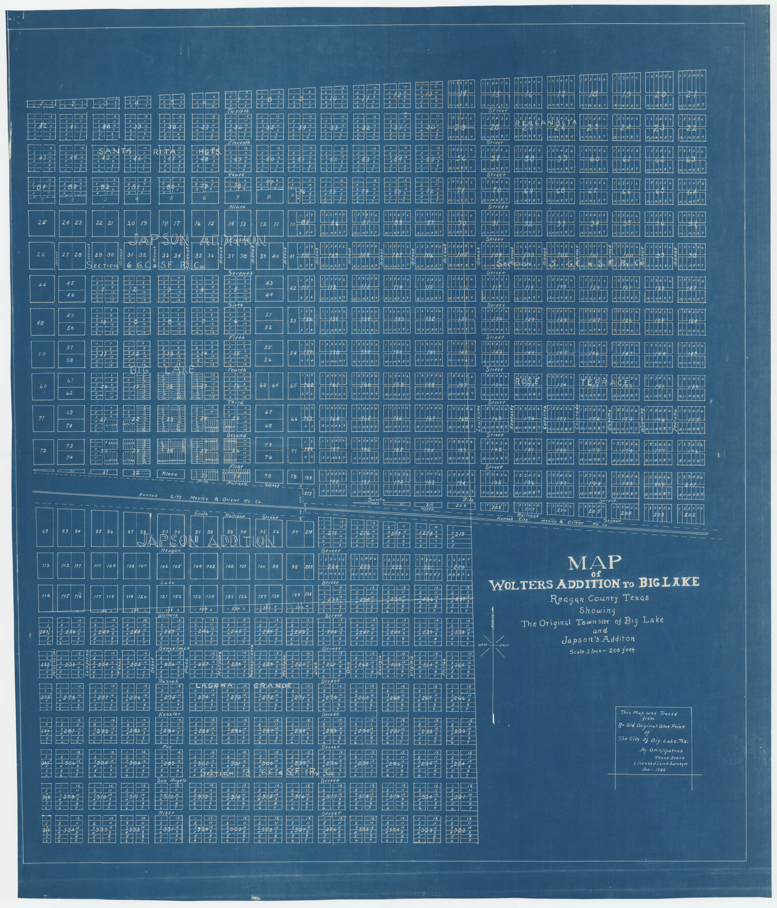
Map of Wolters Addition to Big Lake Reagan County, Texas Showing the Original Townsite of Big Lake and Japson's Addition
-
Map/Doc
89712
-
Collection
Twichell Survey Records
-
Object Dates
1/1948 (Creation Date)
-
People and Organizations
O.H. Kilpatrick (Surveyor/Engineer)
-
Counties
Reagan
-
Height x Width
42.4 x 49.6 inches
107.7 x 126.0 cm
-
Comments
Note on map: "This map was traced from an old original blue print of The City of Big Lake, Tex. by O. H. Kilpatrick, Texas State Licensed Land Surveyor"
Part of: Twichell Survey Records
[I. & G. N. Block 1 and surroundings]
![91596, [I. & G. N. Block 1 and surroundings], Twichell Survey Records](https://historictexasmaps.com/wmedia_w700/maps/91596-1.tif.jpg)
Print $20.00
- Digital $50.00
[I. & G. N. Block 1 and surroundings]
1892
Size 18.6 x 25.6 inches
Map/Doc 91596
[Surveys covering parts of Blocks 5T, R2, M24, M23]
![92122, [Surveys covering parts of Blocks 5T, R2, M24, M23], Twichell Survey Records](https://historictexasmaps.com/wmedia_w700/maps/92122-1.tif.jpg)
Print $20.00
- Digital $50.00
[Surveys covering parts of Blocks 5T, R2, M24, M23]
Size 15.0 x 19.0 inches
Map/Doc 92122
[Capitol Land Reservation, Brooks and Burleson Blocks 1 and 2, H. & T. C. RR. Company Block 48]
![90773, [Capitol Land Reservation, Brooks and Burleson Blocks 1 and 2, H. & T. C. RR. Company Block 48], Twichell Survey Records](https://historictexasmaps.com/wmedia_w700/maps/90773-1.tif.jpg)
Print $20.00
- Digital $50.00
[Capitol Land Reservation, Brooks and Burleson Blocks 1 and 2, H. & T. C. RR. Company Block 48]
1902
Size 22.0 x 17.1 inches
Map/Doc 90773
Lgs. 276 thru 280-289, 333, 336, 345, 355 thru 357, 367, Blk. K11

Print $20.00
- Digital $50.00
Lgs. 276 thru 280-289, 333, 336, 345, 355 thru 357, 367, Blk. K11
Size 28.0 x 12.3 inches
Map/Doc 91429
Working Sketch in Archer County

Print $20.00
- Digital $50.00
Working Sketch in Archer County
1924
Size 30.3 x 42.2 inches
Map/Doc 90171
Survey of Improvements on Meeks Gin Site Town of Ropes Hockley County, Texas

Print $20.00
- Digital $50.00
Survey of Improvements on Meeks Gin Site Town of Ropes Hockley County, Texas
1957
Size 13.0 x 17.6 inches
Map/Doc 92214
Sketch of Bull Pasture

Print $3.00
- Digital $50.00
Sketch of Bull Pasture
Size 9.3 x 12.1 inches
Map/Doc 91450
[Block 3 and part of Block 2]
![90760, [Block 3 and part of Block 2], Twichell Survey Records](https://historictexasmaps.com/wmedia_w700/maps/90760-1.tif.jpg)
Print $2.00
- Digital $50.00
[Block 3 and part of Block 2]
1882
Size 13.1 x 9.1 inches
Map/Doc 90760
George M. Slaughter Block Hockley and Cochran Counties, Texas

Print $20.00
- Digital $50.00
George M. Slaughter Block Hockley and Cochran Counties, Texas
1929
Size 14.1 x 25.2 inches
Map/Doc 92238
Revised Map of Pendleton-Baxter-Addition to Shamrock Located on N.E. 1/4 Section 37, Block 17 H. & G.N.RR.Co., Wheeler County, Texas

Print $20.00
- Digital $50.00
Revised Map of Pendleton-Baxter-Addition to Shamrock Located on N.E. 1/4 Section 37, Block 17 H. & G.N.RR.Co., Wheeler County, Texas
Size 16.7 x 18.8 inches
Map/Doc 92123
[Blocks C & C2]
![90747, [Blocks C & C2], Twichell Survey Records](https://historictexasmaps.com/wmedia_w700/maps/90747-1.tif.jpg)
Print $20.00
- Digital $50.00
[Blocks C & C2]
1906
Size 24.7 x 8.9 inches
Map/Doc 90747
[Blocks K3-K8, K11]
![90507, [Blocks K3-K8, K11], Twichell Survey Records](https://historictexasmaps.com/wmedia_w700/maps/90507-1.tif.jpg)
Print $20.00
- Digital $50.00
[Blocks K3-K8, K11]
1887
Size 13.2 x 14.6 inches
Map/Doc 90507
You may also like
Flight Mission No. BQY-4M, Frame 65, Harris County

Print $20.00
- Digital $50.00
Flight Mission No. BQY-4M, Frame 65, Harris County
1953
Size 18.7 x 22.4 inches
Map/Doc 85274
Hudspeth County Working Sketch 24

Print $40.00
- Digital $50.00
Hudspeth County Working Sketch 24
1967
Size 46.0 x 54.9 inches
Map/Doc 66306
[Sketch showing Blocks B-11, O-18, P and Mc in case of Laneer vs. Bivens]
![91726, [Sketch showing Blocks B-11, O-18, P and Mc in case of Laneer vs. Bivens], Twichell Survey Records](https://historictexasmaps.com/wmedia_w700/maps/91726-1.tif.jpg)
Print $20.00
- Digital $50.00
[Sketch showing Blocks B-11, O-18, P and Mc in case of Laneer vs. Bivens]
Size 21.2 x 18.6 inches
Map/Doc 91726


Andrews County

Print $40.00
- Digital $50.00
Andrews County
1925
Size 56.5 x 42.8 inches
Map/Doc 89866
Aransas County Sketch File 12

Print $8.00
- Digital $50.00
Aransas County Sketch File 12
Size 14.0 x 8.7 inches
Map/Doc 13118
Freestone County Sketch File 27

Print $2.00
- Digital $50.00
Freestone County Sketch File 27
1934
Size 11.3 x 8.6 inches
Map/Doc 23098
Witt Addition, Subdivision out of Section 6, Block E, City of Lubbock

Print $20.00
- Digital $50.00
Witt Addition, Subdivision out of Section 6, Block E, City of Lubbock
1950
Size 9.1 x 30.9 inches
Map/Doc 92739
Howard County Boundary File 2a

Print $9.00
- Digital $50.00
Howard County Boundary File 2a
Size 14.6 x 11.3 inches
Map/Doc 55118
Harris County Sketch File 102

Print $163.00
- Digital $50.00
Harris County Sketch File 102
1985
Size 11.4 x 8.9 inches
Map/Doc 25915
Webb County Working Sketch 95

Print $20.00
- Digital $50.00
Webb County Working Sketch 95
1991
Size 16.6 x 42.2 inches
Map/Doc 72462