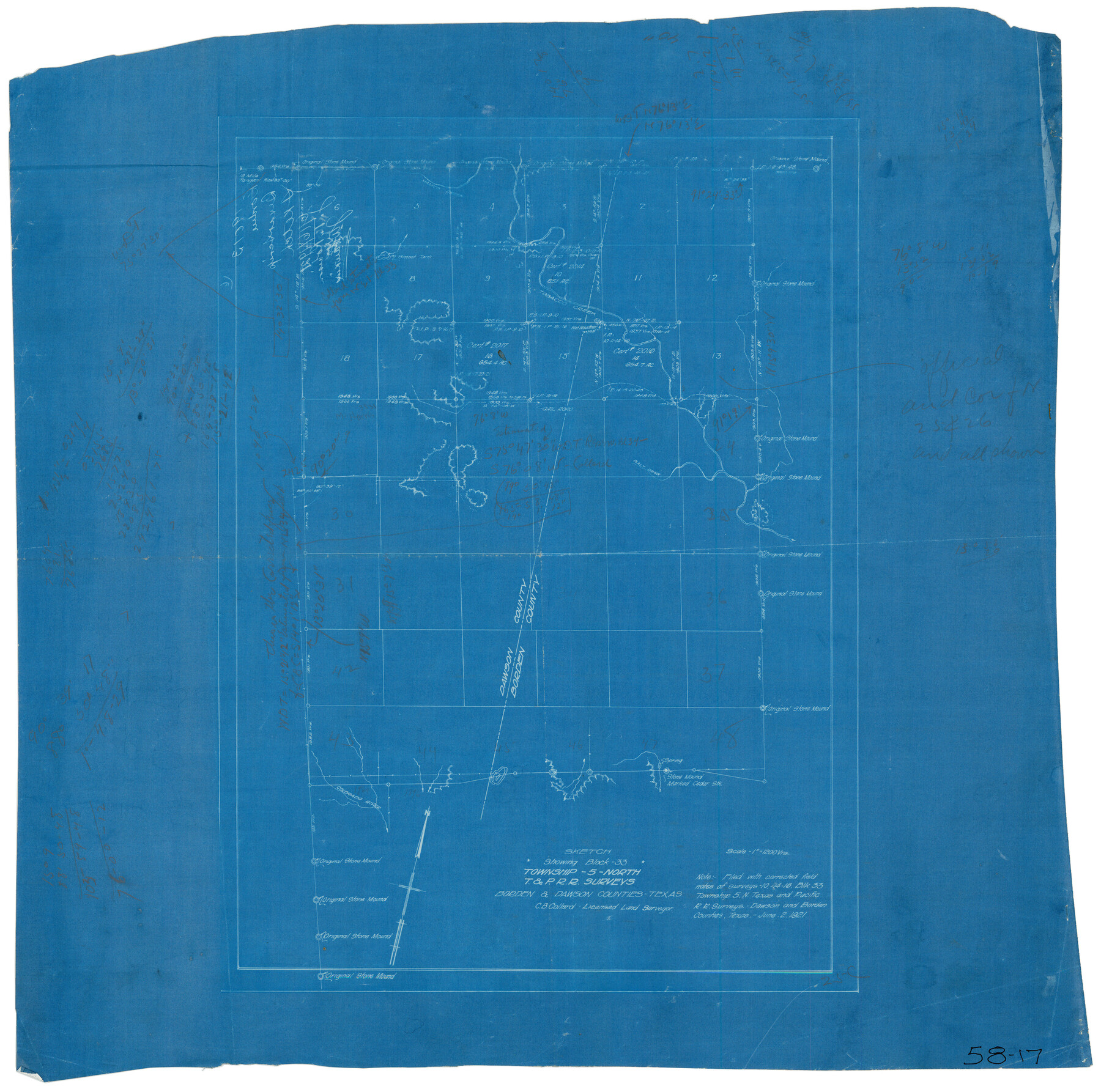
Sketch Showing Block 33, Township 5 North, T. & P. RR. Surveys
58-17
-
Map/Doc
90635
-
Collection
Twichell Survey Records
-
Object Dates
6/2/1921 (Creation Date)
-
People and Organizations
C.B. Collard (Surveyor/Engineer)
-
Counties
Dawson Borden
-
Height x Width
23.2 x 22.7 inches
58.9 x 57.7 cm
Part of: Twichell Survey Records
Nine Central Panhandle Counties, Texas

Print $20.00
- Digital $50.00
Nine Central Panhandle Counties, Texas
1899
Size 41.3 x 35.0 inches
Map/Doc 93045
[W. T. Brewer: M. McDonald, Ralph Gilpin, A. Vanhooser, John Baker, John R. Taylor Surveys]
![90965, [W. T. Brewer: M. McDonald, Ralph Gilpin, A. Vanhooser, John Baker, John R. Taylor Surveys], Twichell Survey Records](https://historictexasmaps.com/wmedia_w700/maps/90965-1.tif.jpg)
Print $2.00
- Digital $50.00
[W. T. Brewer: M. McDonald, Ralph Gilpin, A. Vanhooser, John Baker, John R. Taylor Surveys]
Size 8.9 x 11.3 inches
Map/Doc 90965
Englewood Cemetery Slaton, Texas

Print $20.00
- Digital $50.00
Englewood Cemetery Slaton, Texas
1947
Size 24.4 x 35.2 inches
Map/Doc 92838
[T. & P. RR. Co. Blocks 54, 55 and 76, Townships 1 and 2]
![89888, [T. & P. RR. Co. Blocks 54, 55 and 76, Townships 1 and 2], Twichell Survey Records](https://historictexasmaps.com/wmedia_w700/maps/89888-1.tif.jpg)
Print $20.00
- Digital $50.00
[T. & P. RR. Co. Blocks 54, 55 and 76, Townships 1 and 2]
Size 44.2 x 36.2 inches
Map/Doc 89888
[East line of Captiol Land in Deaf Smith, Castro and Lamb]
![90603, [East line of Captiol Land in Deaf Smith, Castro and Lamb], Twichell Survey Records](https://historictexasmaps.com/wmedia_w700/maps/90603-1.tif.jpg)
Print $20.00
- Digital $50.00
[East line of Captiol Land in Deaf Smith, Castro and Lamb]
Size 45.4 x 17.4 inches
Map/Doc 90603
[Block 1 PO, Surveys 15, 16, and 17]
![91433, [Block 1 PO, Surveys 15, 16, and 17], Twichell Survey Records](https://historictexasmaps.com/wmedia_w700/maps/91433-1.tif.jpg)
Print $20.00
- Digital $50.00
[Block 1 PO, Surveys 15, 16, and 17]
1906
Size 16.6 x 15.6 inches
Map/Doc 91433
[Sketch of Hicks Strip No. 2 between M. H. Hagaman and Z. C. Collier Surveys]
![91914, [Sketch of Hicks Strip No. 2 between M. H. Hagaman and Z. C. Collier Surveys], Twichell Survey Records](https://historictexasmaps.com/wmedia_w700/maps/91914-1.tif.jpg)
Print $20.00
- Digital $50.00
[Sketch of Hicks Strip No. 2 between M. H. Hagaman and Z. C. Collier Surveys]
Size 15.3 x 16.3 inches
Map/Doc 91914
Terry County School Land, Gaines County, Texas

Print $20.00
- Digital $50.00
Terry County School Land, Gaines County, Texas
Size 15.6 x 24.7 inches
Map/Doc 92678
[Additions Surrounding Fort Worth & Denver Railroad Fork]
![92840, [Additions Surrounding Fort Worth & Denver Railroad Fork], Twichell Survey Records](https://historictexasmaps.com/wmedia_w700/maps/92840-1.tif.jpg)
Print $20.00
- Digital $50.00
[Additions Surrounding Fort Worth & Denver Railroad Fork]
Size 32.2 x 32.1 inches
Map/Doc 92840
Highland Place an Addition to City of Lubbock - Plat of Lots and Street

Print $20.00
- Digital $50.00
Highland Place an Addition to City of Lubbock - Plat of Lots and Street
Size 26.0 x 18.1 inches
Map/Doc 92843
Plat Showing Land Owned by City of Lubbock out of Section 3, Block O

Print $20.00
- Digital $50.00
Plat Showing Land Owned by City of Lubbock out of Section 3, Block O
Size 40.4 x 31.1 inches
Map/Doc 92876
[Surveys South of Levi Pruitt and Jno. Welch]
![92091, [Surveys South of Levi Pruitt and Jno. Welch], Twichell Survey Records](https://historictexasmaps.com/wmedia_w700/maps/92091-1.tif.jpg)
Print $20.00
- Digital $50.00
[Surveys South of Levi Pruitt and Jno. Welch]
Size 18.2 x 6.3 inches
Map/Doc 92091
You may also like
[Map of Texas and Pacific Blocks from Brazos River westward through Palo Pinto, Stephens, Shackelford, Jones, Callahan, Taylor, Fisher, Nolan and Mitchell Counties]
![93460, [Map of Texas and Pacific Blocks from Brazos River westward through Palo Pinto, Stephens, Shackelford, Jones, Callahan, Taylor, Fisher, Nolan and Mitchell Counties], General Map Collection](https://historictexasmaps.com/wmedia_w700/maps/93460.tif.jpg)
Print $40.00
- Digital $50.00
[Map of Texas and Pacific Blocks from Brazos River westward through Palo Pinto, Stephens, Shackelford, Jones, Callahan, Taylor, Fisher, Nolan and Mitchell Counties]
Size 87.1 x 18.8 inches
Map/Doc 93460
Flight Mission No. CRK-8P, Frame 103, Refugio County

Print $20.00
- Digital $50.00
Flight Mission No. CRK-8P, Frame 103, Refugio County
1956
Size 18.4 x 22.1 inches
Map/Doc 86964
Travis County Sketch File 31

Print $4.00
- Digital $50.00
Travis County Sketch File 31
1889
Size 12.9 x 8.8 inches
Map/Doc 38345
Starr County Rolled Sketch 10

Print $20.00
- Digital $50.00
Starr County Rolled Sketch 10
1912
Size 15.2 x 24.0 inches
Map/Doc 7797
North Line Garza County/South Line Crosby County

Print $20.00
- Digital $50.00
North Line Garza County/South Line Crosby County
1887
Size 8.3 x 35.1 inches
Map/Doc 90904
Pecos County Rolled Sketch 140

Print $20.00
- Digital $50.00
Pecos County Rolled Sketch 140
1954
Size 28.4 x 38.6 inches
Map/Doc 7275
Mills County Boundary File 1

Print $28.00
- Digital $50.00
Mills County Boundary File 1
Size 8.3 x 8.0 inches
Map/Doc 57259
Amistad International Reservoir on Rio Grande 91

Print $20.00
- Digital $50.00
Amistad International Reservoir on Rio Grande 91
1950
Size 28.5 x 41.0 inches
Map/Doc 75521
Oldham County Boundary File 1c

Print $48.00
- Digital $50.00
Oldham County Boundary File 1c
Size 14.0 x 8.4 inches
Map/Doc 57753
Travis County Rolled Sketch 49

Print $20.00
- Digital $50.00
Travis County Rolled Sketch 49
Size 43.0 x 39.9 inches
Map/Doc 10017
Kendall County Sketch File 16a

Print $40.00
- Digital $50.00
Kendall County Sketch File 16a
1891
Size 15.3 x 13.7 inches
Map/Doc 28707
Honey Grove, Tex., Fannin County, 1886

Print $20.00
Honey Grove, Tex., Fannin County, 1886
1886
Size 18.4 x 23.9 inches
Map/Doc 93479