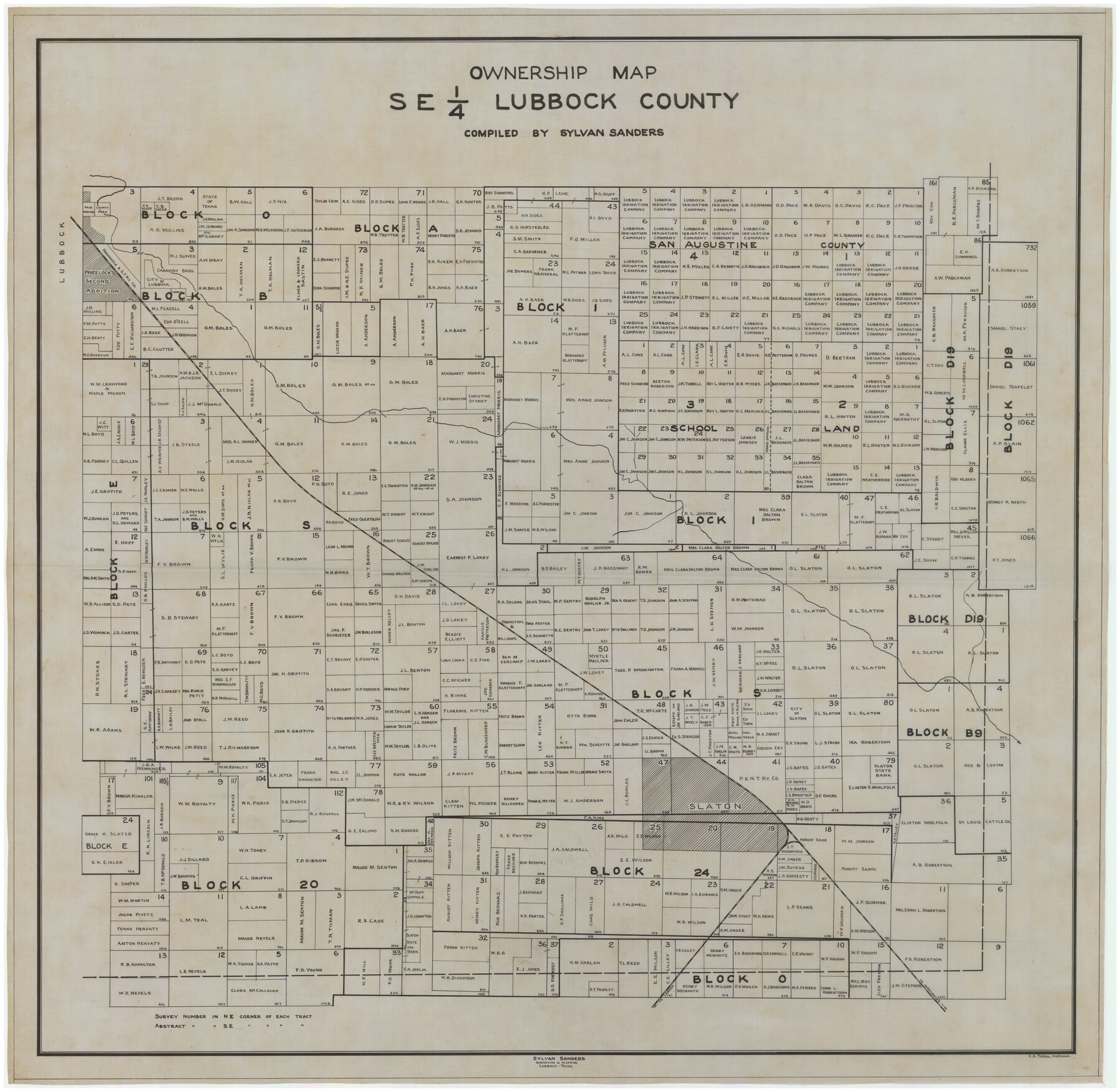
Ownership Map SE 1/4 Lubbock County
-
Map/Doc
89895
-
Collection
Twichell Survey Records
-
People and Organizations
Sylvan Sanders (Compiler)
Sylvan Sanders (Surveyor/Engineer)
C.A. Tubbs (Draftsman)
-
Counties
Lubbock
-
Height x Width
37.2 x 36.4 inches
94.5 x 92.5 cm
Part of: Twichell Survey Records
[Southern Part of County]
![91905, [Southern Part of County], Twichell Survey Records](https://historictexasmaps.com/wmedia_w700/maps/91905-1.tif.jpg)
Print $2.00
- Digital $50.00
[Southern Part of County]
Size 9.8 x 7.6 inches
Map/Doc 91905
[Surveys on the south side of the Canadian River]
![91788, [Surveys on the south side of the Canadian River], Twichell Survey Records](https://historictexasmaps.com/wmedia_w700/maps/91788-1.tif.jpg)
Print $3.00
- Digital $50.00
[Surveys on the south side of the Canadian River]
Size 11.2 x 15.9 inches
Map/Doc 91788
Flake Addition a Subdivision of SE Part of NE Quarter Section 4, Block O

Print $20.00
- Digital $50.00
Flake Addition a Subdivision of SE Part of NE Quarter Section 4, Block O
Size 27.4 x 19.5 inches
Map/Doc 92823
[Pencil sketch of C. B., H. L. and Jno. Robertson and surrounding surveys]
![89981, [Pencil sketch of C. B., H. L. and Jno. Robertson and surrounding surveys], Twichell Survey Records](https://historictexasmaps.com/wmedia_w700/maps/89981-1.tif.jpg)
Print $20.00
- Digital $50.00
[Pencil sketch of C. B., H. L. and Jno. Robertson and surrounding surveys]
Size 21.1 x 9.8 inches
Map/Doc 89981
John H. Wills' Official Map of Amarillo, Potter Counter, Texas

Print $40.00
- Digital $50.00
John H. Wills' Official Map of Amarillo, Potter Counter, Texas
1909
Size 48.9 x 45.4 inches
Map/Doc 93118
[North Part of T. A. Thomson, Block T]
![91075, [North Part of T. A. Thomson, Block T], Twichell Survey Records](https://historictexasmaps.com/wmedia_w700/maps/91075-1.tif.jpg)
Print $20.00
- Digital $50.00
[North Part of T. A. Thomson, Block T]
Size 17.6 x 14.3 inches
Map/Doc 91075
[Garza, Blanco, Uvalde and Crosby County School Land]
![90252, [Garza, Blanco, Uvalde and Crosby County School Land], Twichell Survey Records](https://historictexasmaps.com/wmedia_w700/maps/90252-1.tif.jpg)
Print $20.00
- Digital $50.00
[Garza, Blanco, Uvalde and Crosby County School Land]
1913
Size 12.4 x 12.2 inches
Map/Doc 90252
Crosby Co. Sketch

Print $20.00
- Digital $50.00
Crosby Co. Sketch
1904
Size 21.2 x 24.4 inches
Map/Doc 90349
Crockett County, Texas

Print $20.00
- Digital $50.00
Crockett County, Texas
Size 24.7 x 19.5 inches
Map/Doc 90316
Tech Memorial Park, Inc. Section Q

Print $20.00
- Digital $50.00
Tech Memorial Park, Inc. Section Q
Size 34.8 x 21.2 inches
Map/Doc 92357
[Sketch showing Blocks B-11, G and M-2 and 3, L, and 47, Sections 77-102]
![91733, [Sketch showing Blocks B-11, G and M-2 and 3, L, and 47, Sections 77-102], Twichell Survey Records](https://historictexasmaps.com/wmedia_w700/maps/91733-1.tif.jpg)
Print $20.00
- Digital $50.00
[Sketch showing Blocks B-11, G and M-2 and 3, L, and 47, Sections 77-102]
Size 25.4 x 18.8 inches
Map/Doc 91733
Artesian Company Subdivision

Print $20.00
- Digital $50.00
Artesian Company Subdivision
1955
Size 12.0 x 15.8 inches
Map/Doc 92698
You may also like
Lake Austin, Travis County, Texas

Print $20.00
- Digital $50.00
Lake Austin, Travis County, Texas
1937
Size 24.8 x 16.4 inches
Map/Doc 2056
Right of Way and Track Map International & Gt. Northern Ry. operated by the International & Gt. Northern Ry. Co., Columbia Branch Gulf Division

Print $40.00
- Digital $50.00
Right of Way and Track Map International & Gt. Northern Ry. operated by the International & Gt. Northern Ry. Co., Columbia Branch Gulf Division
1917
Size 24.8 x 56.3 inches
Map/Doc 64593
Brown County Working Sketch 11

Print $20.00
- Digital $50.00
Brown County Working Sketch 11
1983
Size 45.5 x 43.1 inches
Map/Doc 67776
Presidio County Rolled Sketch 1

Print $20.00
- Digital $50.00
Presidio County Rolled Sketch 1
Size 24.5 x 15.7 inches
Map/Doc 7325
Panola County Working Sketch 41

Print $20.00
- Digital $50.00
Panola County Working Sketch 41
1995
Map/Doc 71450
Flight Mission No. DCL-7C, Frame 120, Kenedy County

Print $20.00
- Digital $50.00
Flight Mission No. DCL-7C, Frame 120, Kenedy County
1943
Size 18.5 x 22.4 inches
Map/Doc 86085
Austin County Sketch File 18

Print $14.00
- Digital $50.00
Austin County Sketch File 18
Size 12.8 x 8.2 inches
Map/Doc 13927
[Sketch showing Capitol Lands]
![89725, [Sketch showing Capitol Lands], Twichell Survey Records](https://historictexasmaps.com/wmedia_w700/maps/89725-1.tif.jpg)
Print $40.00
- Digital $50.00
[Sketch showing Capitol Lands]
Size 38.3 x 72.0 inches
Map/Doc 89725
Refugio County Boundary File 3

Print $4.00
- Digital $50.00
Refugio County Boundary File 3
Size 14.0 x 8.7 inches
Map/Doc 58244
Andrews County Rolled Sketch 32

Print $20.00
- Digital $50.00
Andrews County Rolled Sketch 32
1950
Size 26.2 x 16.4 inches
Map/Doc 77176
Map of Chambers County

Print $20.00
- Digital $50.00
Map of Chambers County
1896
Size 22.2 x 23.3 inches
Map/Doc 3385
San Augustine County Working Sketch 16

Print $20.00
- Digital $50.00
San Augustine County Working Sketch 16
1962
Size 22.2 x 25.0 inches
Map/Doc 63704