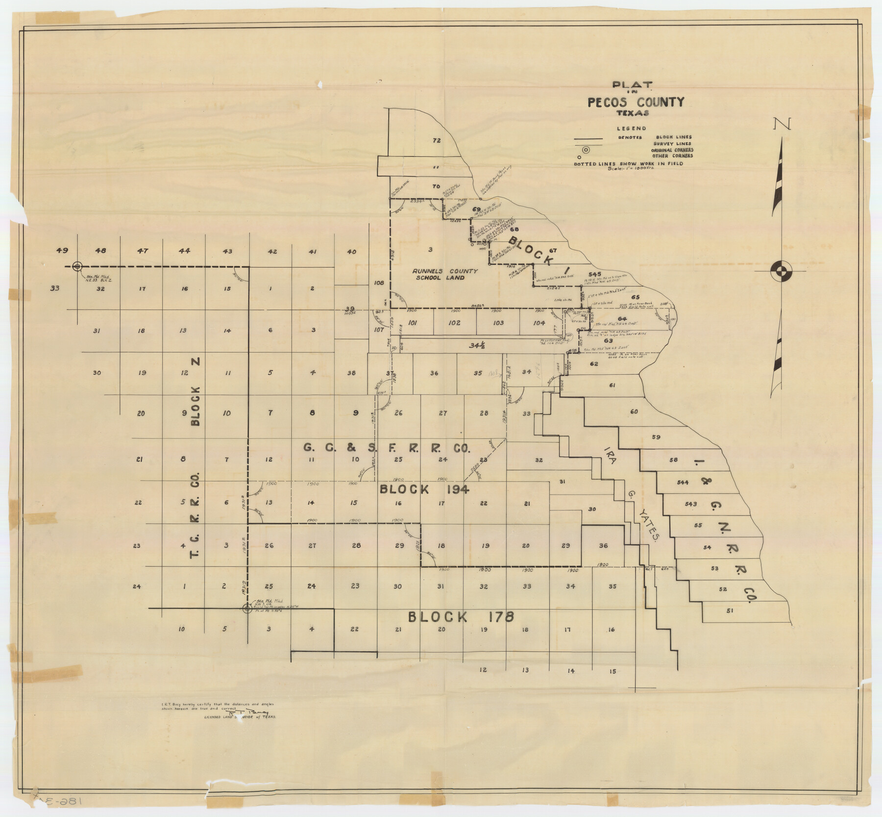
Plat in Pecos County, Texas
186-34
-
Map/Doc
89830
-
Collection
Twichell Survey Records
-
People and Organizations
R.T. Bucy (Surveyor/Engineer)
-
Counties
Pecos
-
Height x Width
39.1 x 36.2 inches
99.3 x 92.0 cm
Part of: Twichell Survey Records
[G. C. & S. F. Ry. Co. Block H, E. L. & R. R. Ry. Co. Block D7 and vicinity]
![91864, [G. C. & S. F. Ry. Co. Block H, E. L. & R. R. Ry. Co. Block D7 and vicinity], Twichell Survey Records](https://historictexasmaps.com/wmedia_w700/maps/91864-1.tif.jpg)
Print $20.00
- Digital $50.00
[G. C. & S. F. Ry. Co. Block H, E. L. & R. R. Ry. Co. Block D7 and vicinity]
Size 15.0 x 18.5 inches
Map/Doc 91864
[Plat showing well locations]
![91667, [Plat showing well locations], Twichell Survey Records](https://historictexasmaps.com/wmedia_w700/maps/91667-1.tif.jpg)
Print $3.00
- Digital $50.00
[Plat showing well locations]
Size 13.3 x 11.3 inches
Map/Doc 91667
[Public Domain Surrounded by Blocks Z, C4, C3, A2, 1]
![92427, [Public Domain Surrounded by Blocks Z, C4, C3, A2, 1], Twichell Survey Records](https://historictexasmaps.com/wmedia_w700/maps/92427-1.tif.jpg)
Print $20.00
- Digital $50.00
[Public Domain Surrounded by Blocks Z, C4, C3, A2, 1]
Size 22.5 x 26.3 inches
Map/Doc 92427
Gordon Addition to Idalou

Print $20.00
- Digital $50.00
Gordon Addition to Idalou
1954
Size 22.6 x 10.8 inches
Map/Doc 92827
George M. Slaughter Block Hockley and Cochran Counties, Texas

Print $20.00
- Digital $50.00
George M. Slaughter Block Hockley and Cochran Counties, Texas
1929
Size 14.1 x 25.2 inches
Map/Doc 92238
Map of Pecos County, Texas

Print $20.00
- Digital $50.00
Map of Pecos County, Texas
Size 18.9 x 22.8 inches
Map/Doc 91573
[Southwest part of County]
![90922, [Southwest part of County], Twichell Survey Records](https://historictexasmaps.com/wmedia_w700/maps/90922-1.tif.jpg)
Print $20.00
- Digital $50.00
[Southwest part of County]
Size 28.8 x 18.4 inches
Map/Doc 90922
Chapman and Farlin Producing Co. Cogdell Ranch Kent County, Texas

Print $20.00
- Digital $50.00
Chapman and Farlin Producing Co. Cogdell Ranch Kent County, Texas
1951
Size 12.6 x 16.6 inches
Map/Doc 92193
Map of W. D. Johnson's Pasture

Print $20.00
- Digital $50.00
Map of W. D. Johnson's Pasture
Size 25.1 x 15.0 inches
Map/Doc 90284
General Highway Map Lynn County

Print $20.00
- Digital $50.00
General Highway Map Lynn County
1949
Size 25.8 x 18.8 inches
Map/Doc 92901
John DePauw Lands

Print $20.00
- Digital $50.00
John DePauw Lands
1954
Size 22.0 x 18.8 inches
Map/Doc 92503
Map of Spearman Lands

Print $20.00
- Digital $50.00
Map of Spearman Lands
Size 20.0 x 15.4 inches
Map/Doc 90793
You may also like
Palo Pinto County Sketch File A

Print $6.00
- Digital $50.00
Palo Pinto County Sketch File A
Size 8.7 x 4.1 inches
Map/Doc 33389
Rusk County Sketch File 27a

Print $10.00
Rusk County Sketch File 27a
1936
Size 14.2 x 8.8 inches
Map/Doc 35532
Midland County Working Sketch 1

Print $20.00
- Digital $50.00
Midland County Working Sketch 1
Size 26.8 x 8.7 inches
Map/Doc 70981
Mills County Working Sketch 5

Print $3.00
- Digital $50.00
Mills County Working Sketch 5
1914
Size 13.1 x 10.8 inches
Map/Doc 71035
New Map of the State of Texas Compiled from J. De Cordova's large Map

Print $20.00
- Digital $50.00
New Map of the State of Texas Compiled from J. De Cordova's large Map
1856
Size 17.5 x 27.0 inches
Map/Doc 76172
Fort Bend County Working Sketch 30

Print $20.00
- Digital $50.00
Fort Bend County Working Sketch 30
1983
Size 13.6 x 13.6 inches
Map/Doc 69236
New Counties in the Panhandle

Print $20.00
- Digital $50.00
New Counties in the Panhandle
Size 24.4 x 21.3 inches
Map/Doc 69765
Calhoun County NRC Article 33.136 Sketch 15

Print $46.00
Calhoun County NRC Article 33.136 Sketch 15
2025
Map/Doc 97428
Brazos River, Brazos River Sheet 6

Print $20.00
- Digital $50.00
Brazos River, Brazos River Sheet 6
1926
Size 27.9 x 23.0 inches
Map/Doc 69670
San Patricio County Sketch File 44

Print $12.00
- Digital $50.00
San Patricio County Sketch File 44
1942
Size 11.4 x 8.9 inches
Map/Doc 36267
Palo Pinto County Sketch File 2

Print $4.00
- Digital $50.00
Palo Pinto County Sketch File 2
1857
Size 8.2 x 10.3 inches
Map/Doc 33392
Real County Working Sketch 18

Print $20.00
- Digital $50.00
Real County Working Sketch 18
1943
Size 26.5 x 33.3 inches
Map/Doc 71910