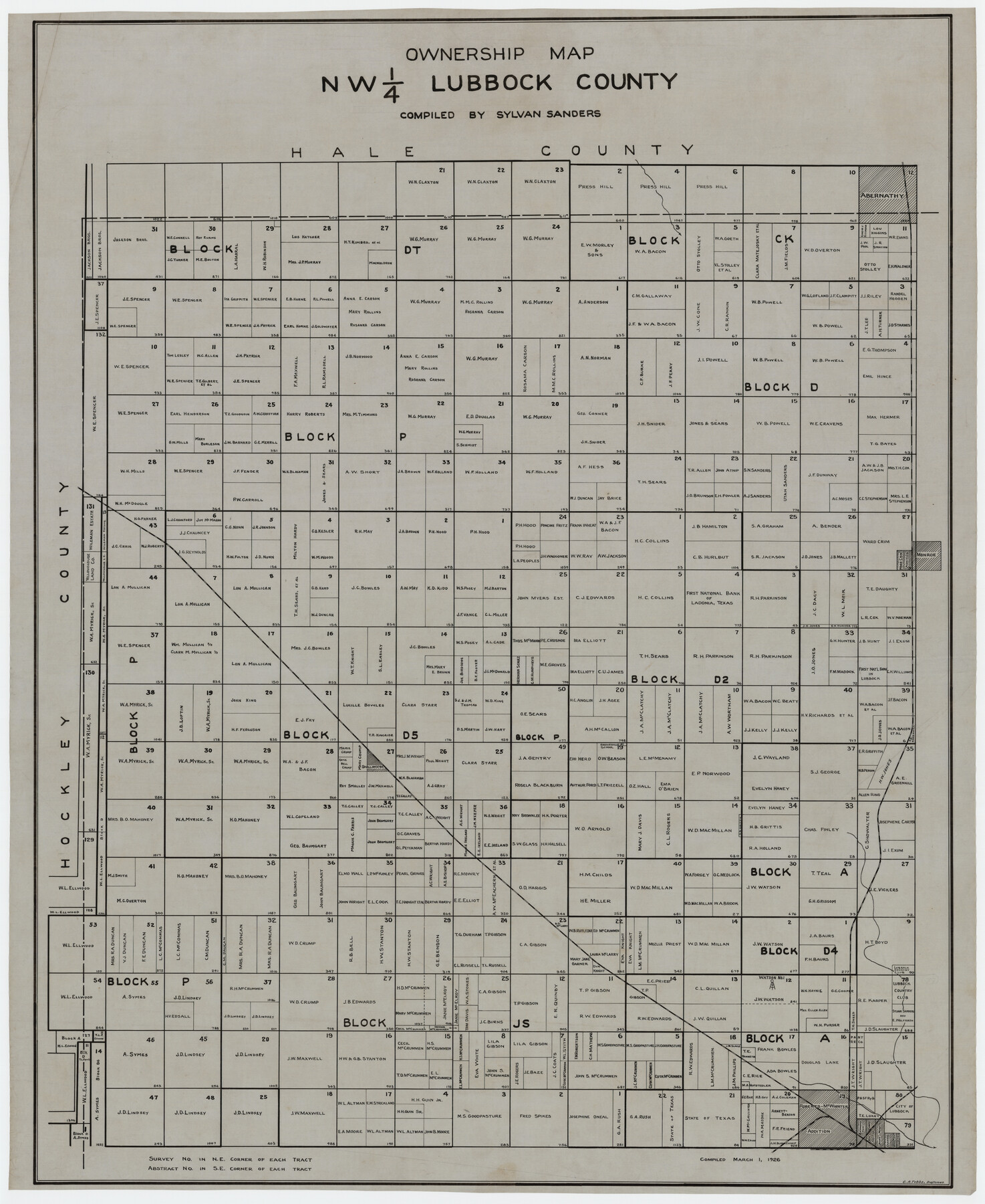
Ownership Map NW 1/4 Lubbock County
-
Map/Doc
89698
-
Collection
Twichell Survey Records
-
Object Dates
3/1/1926 (Creation Date)
-
People and Organizations
Sylvan Sanders (Compiler)
Sylvan Sanders (Surveyor/Engineer)
C.A. Tubbs (Draftsman)
-
Counties
Lubbock
-
Height x Width
32.5 x 39.6 inches
82.6 x 100.6 cm
Part of: Twichell Survey Records
John B. Slaughter Ranch Situated in Garza County, Texas

Print $20.00
- Digital $50.00
John B. Slaughter Ranch Situated in Garza County, Texas
Size 33.2 x 45.1 inches
Map/Doc 92658
Working Sketch Bastrop County

Print $20.00
- Digital $50.00
Working Sketch Bastrop County
1923
Size 23.2 x 13.0 inches
Map/Doc 90151

[G. H. & H. Block 2]
![91894, [G. H. & H. Block 2], Twichell Survey Records](https://historictexasmaps.com/wmedia_w700/maps/91894-1.tif.jpg)
Print $20.00
- Digital $50.00
[G. H. & H. Block 2]
Size 20.6 x 18.4 inches
Map/Doc 91894
[S.E. corner of Sec. 48, Blk. 35 T5N to N.E. corner of Sec. 1, Blk. 35 T5N]
![89826, [S.E. corner of Sec. 48, Blk. 35 T5N to N.E. corner of Sec. 1, Blk. 35 T5N], Twichell Survey Records](https://historictexasmaps.com/wmedia_w700/maps/89826-1.tif.jpg)
Print $40.00
- Digital $50.00
[S.E. corner of Sec. 48, Blk. 35 T5N to N.E. corner of Sec. 1, Blk. 35 T5N]
1907
Size 7.2 x 72.9 inches
Map/Doc 89826
[NE Quarter Section 11 Block CK Lubbock County, Texas]
![92871, [NE Quarter Section 11 Block CK Lubbock County, Texas], Twichell Survey Records](https://historictexasmaps.com/wmedia_w700/maps/92871-1.tif.jpg)
Print $20.00
- Digital $50.00
[NE Quarter Section 11 Block CK Lubbock County, Texas]
1949
Size 16.1 x 16.5 inches
Map/Doc 92871
[Sketch of area south of Runnels County School Land League No. 3]
![91544, [Sketch of area south of Runnels County School Land League No. 3], Twichell Survey Records](https://historictexasmaps.com/wmedia_w700/maps/91544-1.tif.jpg)
Print $2.00
- Digital $50.00
[Sketch of area south of Runnels County School Land League No. 3]
Size 11.9 x 9.2 inches
Map/Doc 91544
[Capitol Leagues 217-239]
![90668, [Capitol Leagues 217-239], Twichell Survey Records](https://historictexasmaps.com/wmedia_w700/maps/90668-1.tif.jpg)
Print $20.00
- Digital $50.00
[Capitol Leagues 217-239]
Size 26.9 x 26.6 inches
Map/Doc 90668
![90573, [Block 3], Twichell Survey Records](https://historictexasmaps.com/wmedia_w700/maps/90573-1.tif.jpg)
Jno. W. Pritchett Preliminary Official LO Map for Lubbock [County]
![89901, Jno. W. Pritchett Preliminary Official LO Map for Lubbock [County], Twichell Survey Records](https://historictexasmaps.com/wmedia_w700/maps/89901-1.tif.jpg)
Print $20.00
- Digital $50.00
Jno. W. Pritchett Preliminary Official LO Map for Lubbock [County]
Size 41.1 x 40.3 inches
Map/Doc 89901
![91965, [PSL Block B19], Twichell Survey Records](https://historictexasmaps.com/wmedia_w700/maps/91965-1.tif.jpg)
Shackelford County, Map of SE part of Block No. 1, Eastern Texas RR. Co. Survey

Print $20.00
- Digital $50.00
Shackelford County, Map of SE part of Block No. 1, Eastern Texas RR. Co. Survey
Size 19.1 x 19.5 inches
Map/Doc 91899
You may also like
Nueces County Sketch File 42

Print $24.00
- Digital $50.00
Nueces County Sketch File 42
1950
Size 11.0 x 8.6 inches
Map/Doc 32633
Presidio County Sketch File 115

Print $14.00
- Digital $50.00
Presidio County Sketch File 115
1993
Size 11.3 x 8.9 inches
Map/Doc 34835
Travels to the source of the Missouri River and across the American Continent to the Pacific Ocean - Vol. 3

Travels to the source of the Missouri River and across the American Continent to the Pacific Ocean - Vol. 3
1815
Map/Doc 97414
Leon County Sketch File 5

Print $4.00
- Digital $50.00
Leon County Sketch File 5
Size 8.0 x 7.8 inches
Map/Doc 29715
[Surveys in the Bexar District in the vicinity of Salado and Saltillo Creeks]
![234, [Surveys in the Bexar District in the vicinity of Salado and Saltillo Creeks], General Map Collection](https://historictexasmaps.com/wmedia_w700/maps/234.tif.jpg)
Print $2.00
- Digital $50.00
[Surveys in the Bexar District in the vicinity of Salado and Saltillo Creeks]
1847
Size 10.3 x 9.1 inches
Map/Doc 234
Potter County Working Sketch 4

Print $20.00
- Digital $50.00
Potter County Working Sketch 4
1920
Size 41.9 x 34.1 inches
Map/Doc 71664
Duval County Sketch File 39

Print $20.00
- Digital $50.00
Duval County Sketch File 39
Size 32.1 x 23.9 inches
Map/Doc 11395
General Highway Map, Deaf Smith County, Texas

Print $20.00
General Highway Map, Deaf Smith County, Texas
1961
Size 24.5 x 18.1 inches
Map/Doc 79437

[Map of resurvey of H. & G.N. RR. Co. Blk. B2]
![89941, [Map of resurvey of H. & G.N. RR. Co. Blk. B2], Twichell Survey Records](https://historictexasmaps.com/wmedia_w700/maps/89941-1.tif.jpg)
Print $20.00
- Digital $50.00
[Map of resurvey of H. & G.N. RR. Co. Blk. B2]
1888
Size 36.6 x 37.7 inches
Map/Doc 89941
Angelina County Working Sketch 50

Print $20.00
- Digital $50.00
Angelina County Working Sketch 50
1985
Size 34.2 x 43.2 inches
Map/Doc 67133
Karnes County Rolled Sketch 4

Print $20.00
- Digital $50.00
Karnes County Rolled Sketch 4
1961
Size 33.4 x 37.7 inches
Map/Doc 9667