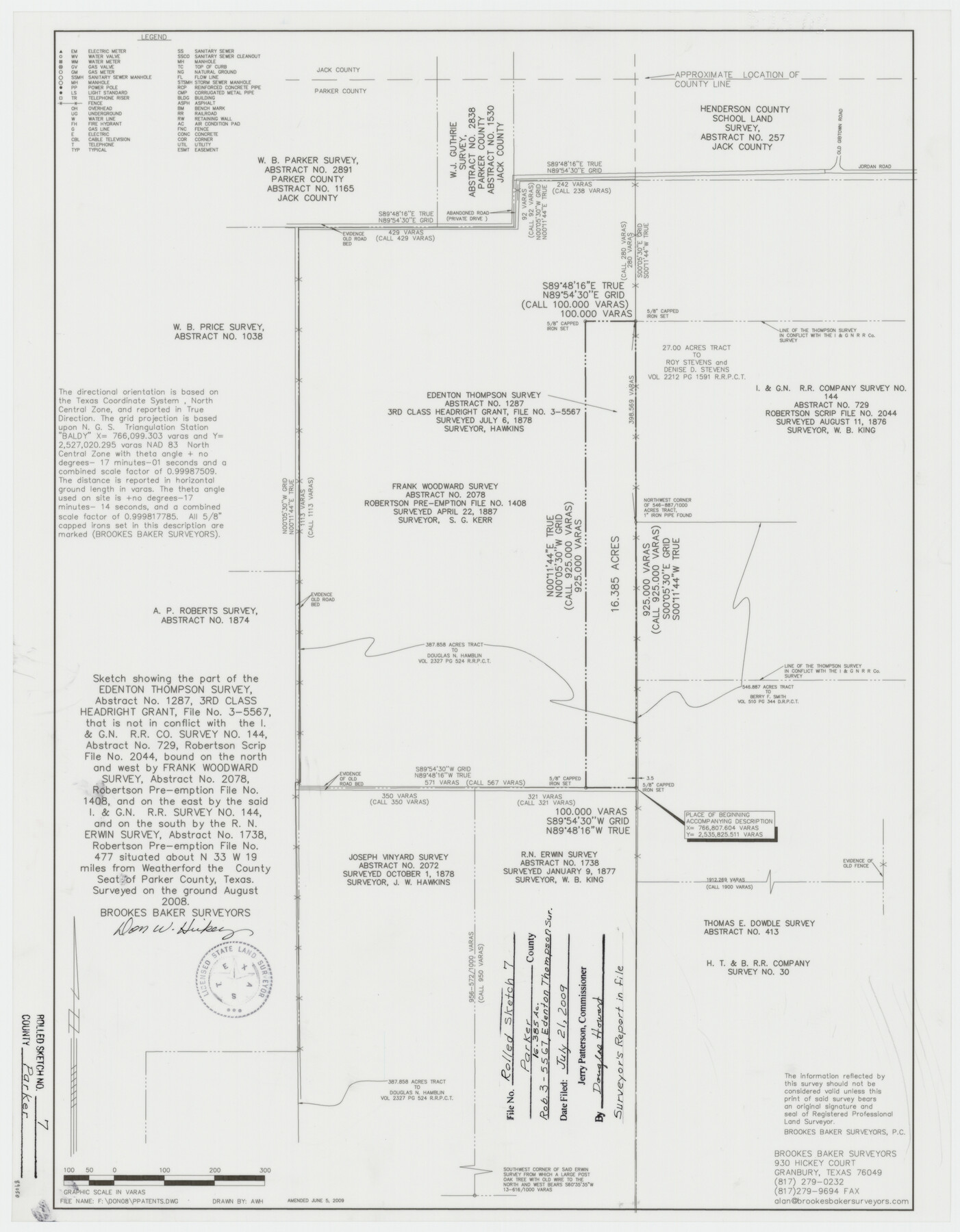
Parker County Rolled Sketch 7
Sketch showing the part of the Edenton Thompson survey, abstract no. 1287, 3rd class headright grant, file no. 3-5567, that is not in conflict with the I. & G. N. R.R. Co. survey no. 144, abstract no. 729, Robertson Scrip file no. 2044
-
Map/Doc
89050
-
Collection
General Map Collection
-
Object Dates
2009/6/5 (Revision Date)
2009/7/21 (File Date)
-
People and Organizations
Don W. Hickey (Surveyor/Engineer)
-
Counties
Parker
-
Subjects
Surveying Rolled Sketch
-
Height x Width
24.5 x 19.1 inches
62.2 x 48.5 cm
-
Medium
mylar, print
Part of: General Map Collection
Hidalgo County Rolled Sketch 3

Print $20.00
- Digital $50.00
Hidalgo County Rolled Sketch 3
1881
Size 27.0 x 20.3 inches
Map/Doc 6206
Parker County Working Sketch 16

Print $20.00
- Digital $50.00
Parker County Working Sketch 16
1990
Map/Doc 71466
New Counties in the Panhandle

Print $20.00
- Digital $50.00
New Counties in the Panhandle
Size 24.4 x 21.3 inches
Map/Doc 69765
Maverick County Sketch File 4

Print $4.00
- Digital $50.00
Maverick County Sketch File 4
1876
Size 9.1 x 8.2 inches
Map/Doc 31051
Little River, Buckholts Sheet

Print $4.00
- Digital $50.00
Little River, Buckholts Sheet
1936
Size 30.0 x 24.2 inches
Map/Doc 65065
Val Verde County Working Sketch 12

Print $20.00
- Digital $50.00
Val Verde County Working Sketch 12
1920
Size 29.0 x 24.3 inches
Map/Doc 72147
Cooke County Working Sketch 27

Print $20.00
- Digital $50.00
Cooke County Working Sketch 27
1975
Size 29.7 x 23.3 inches
Map/Doc 68264
Shackelford County Working Sketch 3

Print $20.00
- Digital $50.00
Shackelford County Working Sketch 3
1919
Size 23.2 x 17.5 inches
Map/Doc 63843
Map of Falls County

Print $20.00
- Digital $50.00
Map of Falls County
1874
Size 20.3 x 21.5 inches
Map/Doc 3528
McMullen County Sketch File 5

Print $4.00
- Digital $50.00
McMullen County Sketch File 5
1854
Size 8.7 x 8.3 inches
Map/Doc 31343
Garza County Rolled Sketch 11

Print $20.00
- Digital $50.00
Garza County Rolled Sketch 11
1915
Size 31.6 x 20.8 inches
Map/Doc 6000
Hale County Sketch File 27

Print $20.00
- Digital $50.00
Hale County Sketch File 27
Size 12.1 x 28.5 inches
Map/Doc 11598
You may also like
Nacogdoches County Rolled Sketch 3

Print $20.00
- Digital $50.00
Nacogdoches County Rolled Sketch 3
1985
Size 39.6 x 27.6 inches
Map/Doc 6837
Map of the Lands Surveyed by the Memphis, El Paso & Pacific R.R. Company

Print $20.00
- Digital $50.00
Map of the Lands Surveyed by the Memphis, El Paso & Pacific R.R. Company
1859
Size 15.0 x 30.0 inches
Map/Doc 2219
Briscoe County Sketch File 14

Print $20.00
- Digital $50.00
Briscoe County Sketch File 14
1910
Size 14.2 x 8.5 inches
Map/Doc 16509
Hardin County Working Sketch 3

Print $3.00
- Digital $50.00
Hardin County Working Sketch 3
1906
Size 9.1 x 11.0 inches
Map/Doc 63401
Angelina County Sketch File 15e

Print $8.00
- Digital $50.00
Angelina County Sketch File 15e
Size 14.1 x 8.7 inches
Map/Doc 12990
The Espuela Land and Cattle Co. L'd. West Pastures of the Spur Ranch

Print $20.00
- Digital $50.00
The Espuela Land and Cattle Co. L'd. West Pastures of the Spur Ranch
1904
Size 41.2 x 44.3 inches
Map/Doc 89947
Tyler County Sketch File 9

Print $4.00
- Digital $50.00
Tyler County Sketch File 9
Size 8.6 x 6.7 inches
Map/Doc 38644
El Nuevo Mexico y Tierras Adyacentes Mapa Levantado para la demarcacion de los Limites de los Dominios Españoles y de los Estados Unidos por el P.D. Jose Pichardo quien lo dedica al Exmo. Sor. D. Fracisco Xavier Venegas Virrey de esta N.E. &. Año de 1811

Print $40.00
El Nuevo Mexico y Tierras Adyacentes Mapa Levantado para la demarcacion de los Limites de los Dominios Españoles y de los Estados Unidos por el P.D. Jose Pichardo quien lo dedica al Exmo. Sor. D. Fracisco Xavier Venegas Virrey de esta N.E. &. Año de 1811
1811
Size 35.8 x 49.6 inches
Map/Doc 95360
Kimble County Working Sketch 35

Print $20.00
- Digital $50.00
Kimble County Working Sketch 35
1946
Size 24.7 x 32.0 inches
Map/Doc 70103

Denton County Working Sketch 6

Print $20.00
- Digital $50.00
Denton County Working Sketch 6
1958
Size 21.3 x 33.0 inches
Map/Doc 68611
Aransas County Sketch File 33

Print $34.00
- Digital $50.00
Aransas County Sketch File 33
1919
Size 14.4 x 8.8 inches
Map/Doc 13303