Uvalde County Rolled Sketch 23
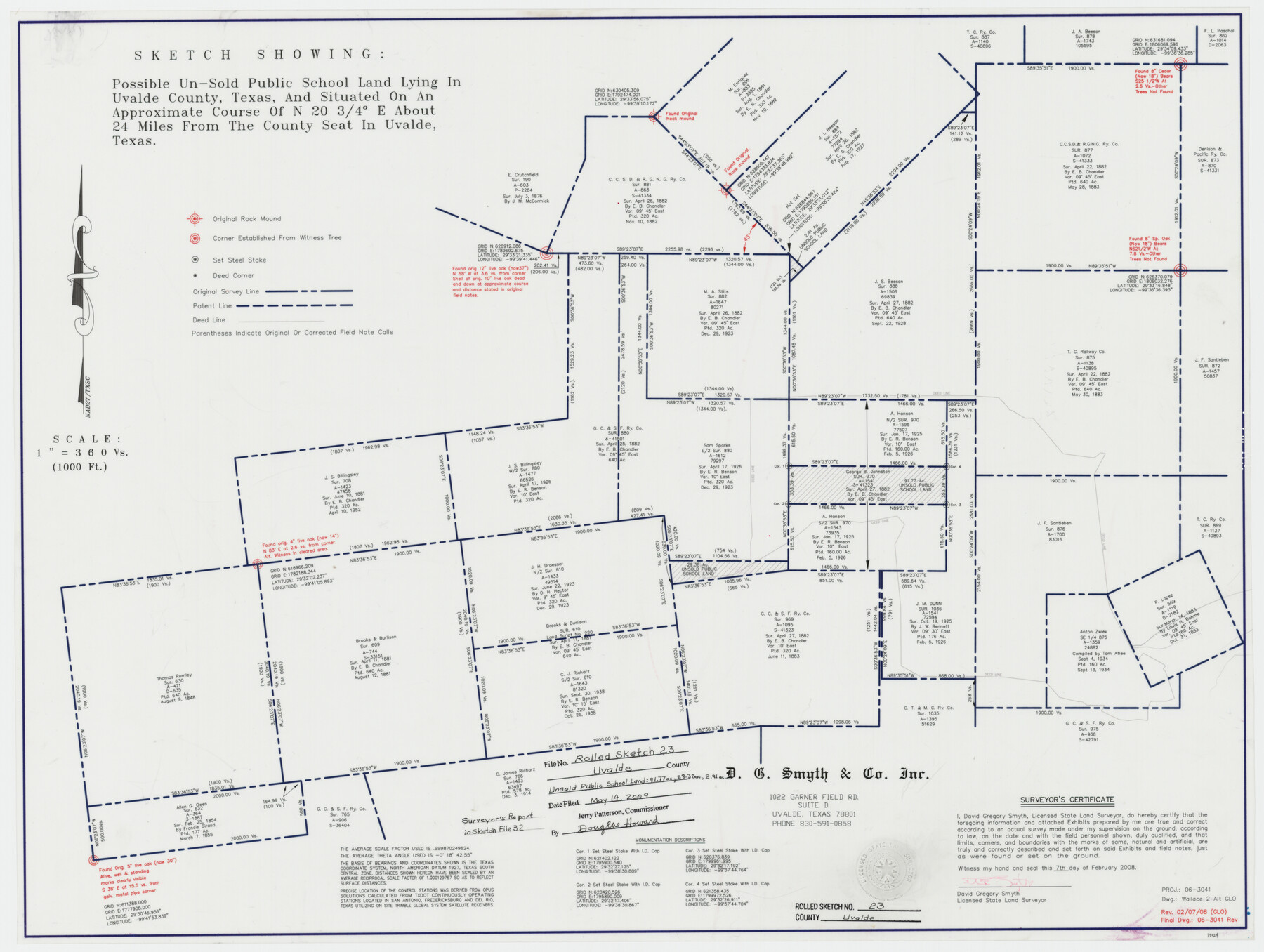
Sketch showing possible un-sold Public School Land lying in Uvalde County, Texas
-
Map/Doc
89024
-
Collection
General Map Collection
-
Object Dates
2008/2/7 (Creation Date)
2009/5/14 (File Date)
-
People and Organizations
D.G. Smyth (Surveyor/Engineer)
-
Counties
Uvalde
-
Subjects
Surveying Rolled Sketch
-
Height x Width
24.6 x 32.6 inches
62.5 x 82.8 cm
-
Medium
mylar, print
-
Scale
1" = 360 varas
-
Comments
See Uvalde County Sketch File 32 (89025) for report.
Related maps
Uvalde County Sketch File 32

Print $12.00
- Digital $50.00
Uvalde County Sketch File 32
2008
Size 8.5 x 11.0 inches
Map/Doc 89025
Part of: General Map Collection
Gonzales County Working Sketch 12

Print $20.00
- Digital $50.00
Gonzales County Working Sketch 12
1981
Size 13.1 x 11.9 inches
Map/Doc 63228
El Paso County Rolled Sketch EC

Print $20.00
- Digital $50.00
El Paso County Rolled Sketch EC
1912
Size 30.1 x 18.2 inches
Map/Doc 5857
Parker County Sketch File 48

Print $20.00
- Digital $50.00
Parker County Sketch File 48
1858
Size 17.6 x 22.3 inches
Map/Doc 12152
Flight Mission No. DQN-1K, Frame 155, Calhoun County

Print $20.00
- Digital $50.00
Flight Mission No. DQN-1K, Frame 155, Calhoun County
1953
Size 18.5 x 22.2 inches
Map/Doc 84214
Childress County Rolled Sketch 8C

Print $20.00
- Digital $50.00
Childress County Rolled Sketch 8C
Size 23.5 x 21.0 inches
Map/Doc 5445
Blanco County Sketch File 35

Print $6.00
- Digital $50.00
Blanco County Sketch File 35
1890
Size 6.3 x 7.0 inches
Map/Doc 14639
Map of Part of Espiritu Santo and San Antonio Bays and Vicinity, Texas

Print $40.00
- Digital $50.00
Map of Part of Espiritu Santo and San Antonio Bays and Vicinity, Texas
1859
Size 31.6 x 53.1 inches
Map/Doc 69983
Flight Mission No. DIX-5P, Frame 140, Aransas County

Print $20.00
- Digital $50.00
Flight Mission No. DIX-5P, Frame 140, Aransas County
1956
Size 17.8 x 18.5 inches
Map/Doc 83801
Brewster County Rolled Sketch 114

Print $20.00
- Digital $50.00
Brewster County Rolled Sketch 114
1964
Size 11.9 x 18.3 inches
Map/Doc 5280
[Map of Terrell County]
![4074, [Map of Terrell County], General Map Collection](https://historictexasmaps.com/wmedia_w700/maps/4074.tif.jpg)
Print $20.00
- Digital $50.00
[Map of Terrell County]
Size 38.0 x 24.0 inches
Map/Doc 4074
Culberson County Rolled Sketch 60

Print $46.00
- Digital $50.00
Culberson County Rolled Sketch 60
1968
Size 58.9 x 31.3 inches
Map/Doc 8761
Armstrong County Sketch File A-2

Print $40.00
- Digital $50.00
Armstrong County Sketch File A-2
1918
Size 27.0 x 36.6 inches
Map/Doc 10843
You may also like
Packery Channel

Print $20.00
- Digital $50.00
Packery Channel
1930
Size 26.6 x 37.1 inches
Map/Doc 2990
Rio Grande Rectification Project, El Paso and Juarez Valley

Print $2.00
- Digital $50.00
Rio Grande Rectification Project, El Paso and Juarez Valley
1935
Size 10.8 x 8.2 inches
Map/Doc 60873
Flight Mission No. BRA-8M, Frame 77, Jefferson County

Print $20.00
- Digital $50.00
Flight Mission No. BRA-8M, Frame 77, Jefferson County
1953
Size 15.9 x 15.7 inches
Map/Doc 85597
Lampasas County

Print $20.00
- Digital $50.00
Lampasas County
1972
Size 35.6 x 44.6 inches
Map/Doc 95565
Crockett County Rolled Sketch 24

Print $20.00
- Digital $50.00
Crockett County Rolled Sketch 24
1924
Size 19.5 x 13.0 inches
Map/Doc 5584
Fisher County Working Sketch 11

Print $20.00
- Digital $50.00
Fisher County Working Sketch 11
1952
Size 21.2 x 35.1 inches
Map/Doc 69145
Erath County Sketch File 21

Print $6.00
- Digital $50.00
Erath County Sketch File 21
Size 9.9 x 12.2 inches
Map/Doc 22302
Galveston Bay & Texas Land Company Scrip No. 6086

Print $20.00
- Digital $50.00
Galveston Bay & Texas Land Company Scrip No. 6086
1830
Size 12.7 x 8.2 inches
Map/Doc 96568
Crane County State of Texas

Print $20.00
- Digital $50.00
Crane County State of Texas
1889
Size 22.9 x 17.6 inches
Map/Doc 4524
Coast Chart No. 210 Aransas Pass and Corpus Christi Bay with the coast to latitude 27° 12' Texas

Print $20.00
- Digital $50.00
Coast Chart No. 210 Aransas Pass and Corpus Christi Bay with the coast to latitude 27° 12' Texas
1913
Size 27.9 x 18.3 inches
Map/Doc 72805
Wilbarger County Rolled Sketch 10

Print $20.00
- Digital $50.00
Wilbarger County Rolled Sketch 10
1983
Size 37.6 x 23.8 inches
Map/Doc 8259
Bowie County Sketch File 5

Print $4.00
- Digital $50.00
Bowie County Sketch File 5
Size 10.1 x 7.5 inches
Map/Doc 14837